Posts

Showing posts from May, 2016

Overnight/Early Morning Storms, Nothing Too Frightening

Image
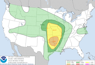
     Hey Good Evening Everybody, How's it going! Everybody is somewhat scared from our last Storm System that came through on Monday/Tuesday. I just want to say THANK YOU!!! Thank You to EVERY LAST Human Being that came here to my Weather Blog, and THANK YOU to every last one of you on Social Media that follow my updates and warnings!!! THANK YOU TO EVERYBODY that support, and encourage me, and lastly THANK YOU to EVERYBODY that depend on me for information! THANK YOU!! You all are the reason I do this, and You all are the reason I've come this far! THANK YOU!!!!  Now that I got that out the way! On to Tonight, an Tomorrow!      Okay, so Later tonight a Storm System will move out of the plains and into Arkansas, this is a Unique one because it's not moving directly Left to Right (West to East) across the state, this one is moving Diagonally From Left/Top to Right/Bottom (Northwest to Southeast). So Northwest Arkansas will have a chance for Strong Storms Overnight Tonight,

*Monday Severe Weather Update*

Image
     GoodMorning everybody, how's it going! Just figured I'd do another update to keep you guys informed, the only thing that has changed is the risk area by the Storm Prediction Center in Norman Oklahoma. The way this will play out according to the Model data, storms will start to fire in West Arkansas, then into South Central Arkansas. Should Storms start to fire and get organized in this risk area, there will be Tornado Warnings with some, if not a lot of these storms. Now we have some rain about to move through, Im looking at the possibility of what we call "Evaporative Cooling" which in this process, the rain cooled air stabilizes the atmosphere limiting the formation, and organization of thunderstorms. That's something I'm looking at. But right now it's precips around, I'm looking for this stuff to blow off, and this evening for that system to move closer to Arkansas, and storms still start to fire out west. In sequential order they'll start

*Severe Weather Update** #MondayMadness

Image
    Hey everybody, how you doing! I hope you're having a good night so far, I hate to be the bear of bad news, but we have some serious weather moving in tomorrow. Here's the deal, there's what we call a "Dry Line" setting up in Oklahoma tomorrow. A Dry Line, is a boundary along the frontal boundary where strong to severe storms start to develop, and get dangerous. That's in Oklahoma, it's tamed for tonight, but by morning, and tomorrow afternoon, it will reintensify over East Oklahoma and start to move closer to West Arkansas.. Well the problem is, tomorrow storms will start to fire up out ahead of that front in areas of instability in West, and into Central Arkansas. Now, let's stop here... I DO EXPECT a Tornado Watch to go out Tomorrow Afternoon for West Arkansas, and a portion of Central Arkansas. If these storms manage to stay Isolated, and off to themselves within this area of instability in West and Central Arkansas, Tornadoes will be a Possibil