Posts

Showing posts from January, 2020

SEVERE WEATHER UPDATE: *MODERATE RISK*

Image
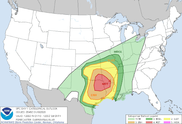
     Hey GoodMorning everybody! I hope You all are enjoying this peaceful Friday morning because Saturday morning will be LOUD, DANGEROUS, AND HECTIC for Meteorologist, and Viewers alike. This is a serious spring setup type system moving into the state today, and tomorrow morning. It's VERY fortunate in some ways that this storm system is moving in when it is, because if this was expected to move through in the evening hours instead of in the middle of the night, we would be talking Tornado Outbreak here. I mean it's bad that this will be an overnight event because this will be when everybody is asleep, and you wont't be able to see what's coming at you which is particular dangerous for motorist. Let Jump into it, in the order of WHAT? WHERE? AND WHEN?       WHAT? ALL MODES Of Severe Weather is Expected Today with these Storms. MAINLY Damaging Straight Lined Winds, Hail, and definitely a chance for Isolated Strong Tornadoes. This Is from the Storm Prediction Center

SEVERE WEATHER UPDATE: Friday Bag of Mixed Weather!

Image
     Hey GoodNight Everybody! I know everybody's been hearing about the developing severe weather situation approaching for Friday night into Saturday morning. Earlier in the week I did a weather update about it, this is just a refresh on the situation, and what I know about it so far from the models. There's a lot to this storm system, from heavy rain chances, to severe weather, to winter weather. This storm system will bring a mixed bag to the state Friday night, and Saturday morning.     First, the heavy rain chances! This Storm System is approaching from the West, but it's drawing in this warm Gulf moisture from the Gulf Of Mexico from a Southwesterly stream. So with this abundance of moisture, heavy rain will be in no short supply! So Flash Flooding will be a definite threat with this storm system over 2 days for the entire state of Arkansas. Marginally this is not a huge Flooding rain event, but that is a lot of rain at one time. So that will create lot's of Flas

Bipolar Arkansas Weather: Watching The GFS

Image
      Happy New Years Everybody!!! The Weather Blog had been on a very long hiatus, but we are   back in the full swing of things! So I've been watching the GFS over the past few days, and the GFS is adamant about wrap around moisture on the back side of this next front coming in changing over as this exists the state. I haven't been buying it too much because the GFS is one of the most inconsistent models outside of that 24 hour window on anything frozen. Now one thing both the GFS and EURO agree on is the possibility for SEVERE WEATHER! Now Severe Weather this early in the year is not unheard of, and it's not uncommon. So there's that.      As far as timing, the rain itself will show up as early as Thursday Morning. Scattered Showers will persist throughout the day Thursday and into Friday. More Scattered Showers Thursday Night. A Second Band of Moisture will setup late Friday Morning into Friday afternoon, the Severe Weather comes into play Friday Evening into Satur