Posts

Showing posts from 2018

Official 2018 Christmas Forecast

Image
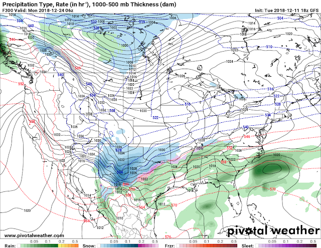
       Hey everybody how's it going!? I hope everybody is having a fantastic night so far, I hope everybody has had the opportunity to get all of their Christmas shopping in, the stores have been crazy, and the good thing is, the weather has been cooperating for the last few days, and that's has been very appreciative to say the least. Now the question is, will it stay like this? I have your answers below.!       Okay, so as far as rain, the GFS has it dry through Christmas, which is a change from days, to weeks ago. I don't totally buy it at the moment, I don't think the entire state will be dry, Little Rock? maybe! Or, maybe a scattered shower early in the day, but for areas in North, and West Arkansas, there is a chance for showers early in the day on Christmas, the latest NAM shows it. Now, weeks ago the GFS was showing snow for Christmas, I did an update about that showing that it was in the realm of possibilities, but you see how probable that is at this point. T

PRELIMINARY Christmas Winter Weather Forecast

Image
      Hey everybody, how's it going? I hope everybody is having a fantastic day so far! I've been watching the GFS very closely over the last 6-7 model runs, and I've been watching something fairly interesting over the last few runs. The GFS has been fairly consistent with the possibilities, but inconsistent with the exact time, and locations as to be expected from 300+ hours out into the future. But from this far in advance the GFS is fairly consistent with the possibilities. So let's take a quick look shall we!? This is the Tuesday noon run of the GFS (Global Forecasting System) weather model, and as you can see here, the GFS has a system moving in from the Southwest, and a arctic front moving in from the Northwest , combine those two, and this is the obvious possibility. But this image has changed in location, and time over the last 4-5 runs, so it will change much more over the next. But this particular model has been consistent with this particular outcome, or

WINTER WEATHER UPDATE: 12/8/18 Saturday Snow

Image
       Hey Everybody, how's it going!? I hope everybody is having a fantastic night so far, and I hope all has been well. Of course we have a developing Winter Weather situation coming together here in the state, and everybody except Santa Claus has made an update about it, everybody has thrown their spin, and two cents in about whats going to happen tomorrow. Now for mine!       As fas as the What? Im expecting an initial changeover to Freezing Rain/Sleet from a cold rain, then changing over to Snow.  For some areas I'm expecting sleet/freezing rain changing over to snow LATE Saturday. For certain areas I'm expecting mostly a cold rain, POSSIBLY changing over to Sleet LATE SATURDAY. As Far as how Much, well the Models are projecting 4-6" up north of Searcy, and 2-4" around Searcy - Clinton. A dusting to a trace for Central Arkansas if that. This is the Latest run of the NAM it shows the Initial changeover to sleet by 6am tomorrow morning in north central Ark

WINTER WEATHER UPDATE: Late Week White Stuff??

Image
      Hey everybody, how's it going? I hope everybody is having a fantastic day so far! Following Friday's severe weather event, I want to thank EVERYBODY for taking heed to watches, and warnings, and my continuous severe weather coverage on social media. Now getting past that, I've been noticing some chances for Winter Weather next weekend on the GFS (Global Forecasting System), one of the Weather Models I monitor, and study. The GFS is a 384 Hour forecast model, that I tend to look at for long range events, especially during the winter. About 132 hours out by next Friday the GFS has been consistent on a frontal boundary moving in along with a cold dip in the jet stream from the north, with it brings rain of course, but the GFS has been hinting on a chance for a changeover in North Arkansas mainly, but I cannot rule out a BREIF changeover further south possibly into North Central/Central Arkansas. See Pics Below. This is the latest run, the 18z Noon run of the GFS. The

November 30th 2018** SEVERE WEATHER UPDATE **

Image
      Hey everybody, how's it going!? I hope everybody is having a fantastic day so far, I just wanted to bring everybody up to date on this developing Severe Weather Situation here in Arkansas this evening. I've been meaning to post this update, but I'm just now finding the time to, so let's get to it, because this is serious business.       Now, as far as what is expected today? Well as it sits, ALL MODES Of Severe Weather is Possible this evening, and tonight! There is Definitely a Chance for Damaging Thunderstorms, Hail, and there is a threat for Tornadoes. Obviously the main concerns are wind, and hail, and lightning. BUT, Tornadoes are a Legit possibility tonight! Night time storms are particularly deadly because you cannot physically see the weather coming. So HAVE YOUR NOAA WEATHER RADIOS ON! And, Keep the News on Standby, as well as Pay attention to all Social Media News sources for weather information. This is an Outlook Map Courtesy of the National Wea

2018 Turkey Day Forecast!!

Image
       Hey everybody, how's it going! I've been pouring over the model guidance over the past few days surrounding, our weather for Thanksgiving day, and Black Friday. The models have been fairly consistent with temperatures, as well as any rain chances. So Let's get right to it.       Now as far as temperatures on Thanksgiving Day, the temperatures look to be in the Low to Mid 40s around the state on Wednesday night heading into thanksgiving morning. So for everybody that will be camping out for the Thanksgiving Black Friday Sales, it will be chilly the morning of thanksgiving. On thanksgiving day the temperatures should warm up into the Low to Mid 50s in most areas of the state. 50s isn't unbearably cold, but it's chilly, so dress accordingly. The night of thanksgiving the temperatures will dip back down into the Mid 40s heading into Friday. Then by Friday evening I'm seeing mid 50s again. On Saturday the GFS (Global Forecasting System) has a high of 62 degre

WINTER WEATHER UPDATE: NOVFREEZE 2018!

Image
      Hey everybody, I hope you guys are having a fantastic night so far. Yes, you read the title right! It is the Official "Novfreeze" of 2018. Calm before the freeze! We have a chance at our first freeze of the year, and when I say "FREEZE" that's what I mean. I'm about to go over how cold? What time? And Will there be anything extra? Check me out!       Okay, so as far as the first question, how cold...... The models have been consistent over the past few days for subfreezing air, I was supposed to do this update yesterday, but I started seeing changes, so I decided to wait a little while longer. Good thing that I did, because just 6 runs ago, the GFS (Global Forecasting System) Weather Model was very aggressive with an opportunity for some frozen precips, but we'll get into that in a second. But as far as how cold? Well the models have been very consistent with high 20s in Central Arkansas on Saturday Morning. Mid-Low 20s up North. Check it out.

SEVERE WEATHER UPDATE: For Monday November 5th

Image
       Hey everybody, I hope you guys are having a fantastic evening so far. In my last Update I discussed the severe weather chances for tomorrow, November 5th. Now, a few Model runs later I have some updated impressions I need you guys to be aware of.         Okay, as far as Timing, I stated that it wasn't really clear yesterday what time this stuff is expected to kick off. Now that I have a more clear picture, I'm expecting development to start in North Central Arkansas from the wave of moisture passing to the north sometime late tomorrow morning, into the Afternoon hours. By Afternoon tomorrow I'm expecting showers, and possibly some storms to develop around Central, and South Central Arkansas. I don't expect much of that to be Severe. Now as we get deeper into the Afternoon, and Evening hours tomorrow, from 12-6pm, I expect a Squall Line to develop as it moves into East Arkansas. I expect everything to be gone by 8 or 9pm (Severe Weather anyways).         Now as

Severe Weather Update : MONDAY MADNESS

Image
       Hey everybody, how's it going!? I hope everybody's having a fantastic evening so far. If you can't tell by the title, there is a chance for Severe Weather on Monday November 5th. Timing is still up in the air, some models suggest Noon - 12am for West - East Arkansas. Some models suggest Monday Night for just East Arkansas. I will be watching these models like a Hawk over the next couple of runs. Now, lets get into what to expect.       As far as what to expect, for awhile now the Tornado threat has not been impressive to me at all, the measure of instability is relatively low, but the amount of twist in the atmosphere, it's what we like to call "Wind Shear", there will be lots of it in the atmosphere on Monday, and Monday Night. So the chance for spin ups with the squall line itself is very prominent! Now, granted spin up Tornadoes are not the biggest in size, but they are fast, and they are capable of taking lives, and damaging property! So with that

Arkansas 2K18 Halloween Weather Forcast

Image
       Hey everybody, I hope you're having a fantastic Sunday Evening! I've been pouring over the model guidance over the past several days, and I've been studying the chances for rain on Halloween day, and night.! I don't think the trick or treaters will like this one! I'm about to talk about rain chances, and temperatures on Halloween day/night, as well as the weather heading into our annual Susan G. Coleman Race For The Cure here in Central Arkansas on Saturday November 3rd.        As far as Halloween goes, there are definite rain chances in the forecast for Wednesday October 31rst 2K18. There will be a front that will move in late Tuesday night and into Wednesday. This front will be strong, so with it will come the chance for ISOLATED Strong to possibly Severe Storms. Now, I'm not expecting a widespread outbreak of Severe Weather, but there is a chance for some storms to be strong to severe. Now, the latest run of the NAM (North American Model) shows the sy

Official Fall 2018 Arkansas Weather Forecast

Image
        Hey everybody, how's it going!? I hope everybody is having a fantastic evening. The time is finally here for me to give my official educated pitch at what this weather pattern will be like as we move through the fall months. I can make this Forecast today, and the complete opposite can happen  It should be noted that with Long range Forecasting (any forecast extending further than 7 days), everything is always in the air as it relates to accuracy. But when it comes down to it, I base my forecast off of education, instinct, and weather analysis. So, that being said, let's get to this Fall!       Now TEMPERATURE WISE; Today October 10th, 2018 is probably the warmest day we will have for at least the next 7 days. Now the front that brought brief spinups, high winds, and power outages to the state also delivered us the cooler temperatures that everybody has been BEGGING for! Today we got to the 80s here in West Little Rock. But at this time it is 65° here in West Little Ro

October 9th 2K18: SEVERE WEATHER UPDATE

Image
       Hey Everybody, I hope everybody is having a fantastic day so far! I'm just wanting to bring everybody up to date regarding a developing Severe Weather situation that we have out in West Arkansas. At the moment we have two Tornado Watches in effect for the West side of the State. I do not anticipate a widespread Tornado outbreak, but I do however expect widespread Severe storms. The Tornado parameters are not really conducive for the development of Tornadoes here in Arkansas. But however, there is a line of Strong to Severe storms moving into the state, and due to the motion of the winds, and how sporadic in nature they tend to be, there is somewhat of a Tornado threat associated with the squall line itself. Because of that reason, the Storm Prediction Center in Norman, Oklahoma has issued a Tornado Watch for the North and West 1/2 of Arkansas. I do expect that watch to be extended to the South to include areas of Southwest, and West Central Arkansas. This is the CAPE (Co

PRELIMINARY Arkansas Fall Outlook 2K18

Image
       Hey everybody! Welcome back to the Arkansas Weather Hawk's Blog!!! Today I'm releasing my Preliminary Fall Weather Outlook for Arkansas! This is only a PRELIMINARY Forecast, meaning this is a premature, early look at just my early thoughts about this coming fall! This is not an Official Forecast, that will come later. But first, I will cover the Short Term.      Lot's of questions I've been getting is when will we have more rain? Another question, is what will the temperatures be like heading into October? Here I will answer those questions. Now, as far as rain, I've checked all 4 weather models that I study, and from what I've seen, our next substantial chance for rain will be this weekend, either Saturday, or Sunday. That chance for rain will come in the form of showers and storms associated with a disturbance that will be moving this way out of the Rockies. The NAM ( North American Model) shows a "Squall Line" (Line of Severe Thunderstorms,

Business As Usual: First Half of August Forecast

       Hey Everybody, how's it going this Afternoon! Well I hope everybody has enjoyed the seasonally nice temperatures! This morning was in the Mid 60s, so I hope everybody enjoyed the nice temperatures!       As I said last week in my Polar Vortex Update, this nice weather wouldn't last very long, and it hasn't.! Thursday is back to business as usual with temperatures in the low to mid 90s in some spots.... We will move into, and through the weekend, as well as through the first half of next week with temperatures in the Mid 90s for highs, and Lows in the Low 80s and high 70s in spots. We will move into the Middle Part of August with highs mostly in the Mid 90s. Next Thursday is expected to be the hottest day of the next 14 day period (at this time, with this run of the models), with a projected high of 97° in Central Arkansas.  That number could change, but this is what's projected at the moment. Now moving into the Middle of August, highs are projected to stay gene

Severe Weather SUNDAY: Severe Weather Update

Image
      Hey everybody, how's it going! This weekend there is definitely a chance for rain, there is somewhat a chance of Thunderstorms. With the cooler air forecasted this coming up work week, their will be a front associated with that air (it always set's up that way). But with the cold front coming, there will be storms along and ahead of it. That front will stall out across the state, this is what will allow the cooler temperatures to set in. But a line of storms, and a chance for severe weather comes with the front.       Okay, what am I expecting? With our weather for tomorrow, with the latest run of the models, I see a chance for Severe Weather to develop, and a chance for a Tornado or two ( THAT CHANCE IS LOW), but the chance for Tornadoes can never be ruled out! Tomorrow will be a mostly quiet day weather wise, with a chance for scattered rain up in the day. But tomorrow evening and night, I will be looking for Thunderstorm development. Tomorrow afternoon, I'm lookin

Polar Vortex Split!! Temperature CHANGE COMING!!!!

Image
       Hey everybody, welcome back to the good ole Arkansas Weather Hawk's blog, where you get the inside scope on what's going on with the bipolar weather in Arkansas! I don't know if some of you have heard of it or not, but we had what's called a Polar Vortex Split. What a Polar Vortex Split is; Is when the Low Pressure Cold air in the North Pole split into two sections of Cold air, when this happens the Jet Stream, which keeps the air trapped up in the Arctic North Pole, starts to wave, and dip down into the southern regions of North America which in turn brings us colder temperatures! Usually this has a tendency to happen during the Winter, but when this happens during the summer, it seems a bit weird, and it will bring us unseasonal temperatures. THIS SUMMER, WE NEED THAT! This is what a "Polar Split" looks like. Notice how the blue eventually floats over the United States? That happens when the Jet Stream weakens, and allow high pressure to develop,

Severe Weather Stat's, Tips, and FAQs

Image
      Hey everybody, How's it going?! I hope everybody is safe of this Saturday evening following Saturday morning's powerful storms that rocked parts of the Natural State. I wanted to do this update, because I've gotten tons of questions from people that have confused last night's wind damage to tornado damage. This is why people die, or get hurt during dangerous weather, due to misconceptions and myths, I want to clear some of that up in this post. Let me start by saying, straight lined winds can be just as bad as tornadoes. Straight Lined Winds can meet and exceed tornado, and possibly even hurricane force winds. ANYTIME you have winds moving that fast there will be damage, we all know that. But just because there is a Severe Thunderstorm Warnings in effect, that doesn't mean yo u should take it any less serious. Sometimes when I broadcast a warning on Social Media, I will go ahead and say " Get to a Safe Place", because I know that the winds this pa