Official 2018 Christmas Forecast
Hey everybody how's it going!? I hope everybody is having a fantastic night so far, I hope everybody has had the opportunity to get all of their Christmas shopping in, the stores have been crazy, and the good thing is, the weather has been cooperating for the last few days, and that's has been very appreciative to say the least. Now the question is, will it stay like this? I have your answers below.!
Okay, so as far as rain, the GFS has it dry through Christmas, which is a change from days, to weeks ago. I don't totally buy it at the moment, I don't think the entire state will be dry, Little Rock? maybe! Or, maybe a scattered shower early in the day, but for areas in North, and West Arkansas, there is a chance for showers early in the day on Christmas, the latest NAM shows it. Now, weeks ago the GFS was showing snow for Christmas, I did an update about that showing that it was in the realm of possibilities, but you see how probable that is at this point. That just goes to show you how models change from day to day, and week to week. Check Pics below!
Okay, so as far as rain, the GFS has it dry through Christmas, which is a change from days, to weeks ago. I don't totally buy it at the moment, I don't think the entire state will be dry, Little Rock? maybe! Or, maybe a scattered shower early in the day, but for areas in North, and West Arkansas, there is a chance for showers early in the day on Christmas, the latest NAM shows it. Now, weeks ago the GFS was showing snow for Christmas, I did an update about that showing that it was in the realm of possibilities, but you see how probable that is at this point. That just goes to show you how models change from day to day, and week to week. Check Pics below!
This is the latest run of the NAM (North American Model), as you can see the showers aren't widespread, but the NAM, and the HRRR (High Resolution Rapid Refresh Model) picks up on this little wave passing by to the north, and possibly triggering some scattered showers but this is early in the daybreak hours on Christmas day. These showers get out of here before Noon Christmas, and dry the rest of the day.
This is the Noon run of the GFS (Global Forecasting System) and, as you can see it shows nothing for the same time during the morning on Christmas day. I tend to side more with the NAM then anything else.
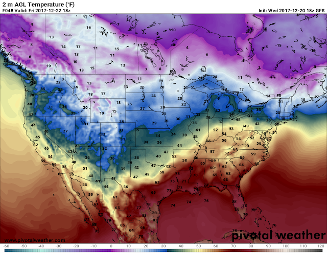
Now as far as temperatures go, the models don't even agree on that at this point, the GFS is warm with temperatures widespread around the state in the 50s. But, on the other hand, the NAM is cold on Christmas with temperatures not getting out of the mid 40s, and with a front passing to the north, I'm sure it will be a little breezy outside. See pics below.
This is the newest NAM, it's colder then the last run for sure, the last run on the NAM had us in the 50s on Christmas day so this run might change, or it might run steady. We'll see how it does over the next 24 hours, the GFS might or might not line up.
This is the noon run of the GFS, the newest 6pm run hasn't come in yet so maybe it will line up with the NAM, and the CFS, we'll see. But as of now, the GFS has us in the low 50s by noon Christmas Day. The Low 50s technically isn't that much warmer, but it's warmer. Either way, the 50s is around average for this time of year. So I won't trip if it's in the 50s, that's cold enough.
Now, looking past Christmas, it's going to rain Wednesday going into Thursday. No severe weather expected at the moment, but there will be a widespread swath of rain to move through Wednesday night, and into Thursday morning, should be gone by Thursday night. If anything changes regarding Christmas, or the Mid Week Monsoon, I'll be sure to let you guys know.! Thanks for coming here to The Arkansas Weather Hawk's Blog, have a VERY MERRY CHRISTMAS EVERYBODY!!!!!
Follow Me On Social Media:
@Omarrian Wilson - Facebook
@OmarrWilson - Twitter
@The Arkansas Weather Hawk - Google Plus
@thearkansas_weatherhawk - Instagram


Comments
Post a Comment