Posts

Showing posts from 2017

Deadly New Year Weather: WINTER WEATHER UPDATE

Image
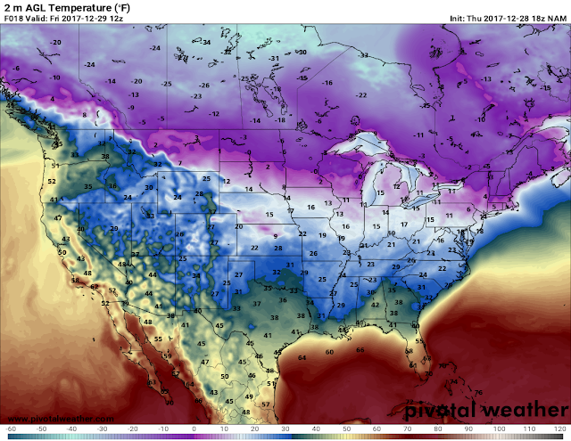
       Hey everybody, how's it going. Well I hope y'all are SAFE AND WARM tonight while reading this. Y'all are probably here for answers as to what the weather will be like, and I know that my title to this doesn't really grant much confidence. But the title is accurate to what we can expect, I'll explain.   Temperatures - Okay, well it's COLD....... Plain and simple, tonight wind chills will be in the teens, actual air temperatures will be in the teens as well in certain areas. Tomorrow (Friday) the temperatures will be a little warmer than it was today, tomorrow the temperatures can possibly get to the 40s (Still Cold), but it's warmer than 32. Now Friday night into Saturday Morning a cold front will move through, once that front moves through that will open the flood gates into the cold air, and this is expected to take place come Sunday (New Years Eve). From Saturday all the way through Tuesday the temperatures will be BELOW freezing (32 Degrees). That

Christmas and Beyond: *WINTER WEATHER UPDATE*

Image
       Hey Everybody, Merry Christmas Eve!!!!! And, Merry Christmas to all.! I PRAY for all that's on the road or in the air traveling on this Christmas holiday! I pray that you guys have safe travels, and make it to your destinations with no issues. Now the purpose of me doing this update is to kind of cover some new model guidance that has come in, especially in regards to tomorrow (Christmas). So I don't want this to be a huge 15 paragraph update, let's cut straight to it!      The NAM (North American Model) is picking up on a disturbance moving through the state on Christmas Night into Tuesday morning. Now I've been getting questions about the likelihood of this verifying, and to be honest I don't think it will. BUT, with that being said since we're so close in time, you never know, maybe the NAM VERIFY, if it does then we appear to have a chance for some flurries or even some light snow showers for North Central Arkansas, it would be rain showers all elsew

Official Christmas Weather Forecast 2017

Image
       Hey everybody how's it going today! I hope all has been well. Yesterday, and Monday we got phenomenal shots at much needed rain across the state. As predicted the bulk of the rain remained in South Central Arkansas, they got some of the highest totals, which is GREAT the farmers out there needed that. Here in Central Arkansas we got decent amounts of rain. I enjoyed the rain, got great rest, I even heard a few rumbles of thunder here in Little Rock.! Now moving past that, we have other shots of rain coming in this weekend, and chance for some flurries at some point after everything is done. Let's dive into this!      Okay, so on my "Preliminary Christmas Weather Forecast" I made last week I was somewhat excited about at least just the possibility for winter weather on Christmas. The models where being somewhat consistent on some type of frozen stuff around Christmas, well within that weekend. BUT, in that very same weather update I stated it was 8+ days out, a

PRELIMINARY Christmas Weather Forecast 2017

Image
       Hey everybody how's it going tonight! I hope all has been well for the past few weeks. For everybody that follow me on social media, I know that you guys have been looking forward to this forecast because there has been talk floating around of a pretty active weather pattern ahead. So, with that said let's dive into it shall we.? Now, just before I get into this, I want to say THANK YOU to everybody on my social media for all of your support for what I do with this weather forecasting, I love you guys, and you all are freaking awesome!       Now, before I get to Christmas we have business to discuss for this weekend. As you all know we have not had substantial rain in WEEKS. Right now we are in an extreme drought conditions due to rain and the lack thereof. There is no doubt that right now we need rain, but if you remember correctly on my "Official Winter Forecast" that I made last month, I mentioned that the beginning of Winter would be a "Late El Nino&q

Winter Makes It's Return 12/4/2017

Image
Hey everybody, How are you all this evening?! Hopefully for those of you near or around Russelville and areas to the West in the state, you guys are safe. I understand that we have a pretty wicked squall line on the move through the state it has a history of at least one Tornado Warning on it as of 8:00PM CDT. So if you live in points to the East including Central Arkansas and East Arkansas, you should beware of that Line. Once it's gone it's gone. Now this Line that's advancing through is associated with a Cold front, this frontal boundary will open the flood gates for a flash flood of cold Arctic air to come surging down through the great plains of the Central USA like a river. Now, with that said, I'm not expecting a sharp sudden pipe bursting cool down, but a fair cool down throughout the Morning and day tomorrow.         Okay, Now as far as how cold, and when? Well based on the latest runs of both the NAM (North American Model), and GFS (Global Forecasting System)

The Arkansas Weather Hawk: Offical Thanksgiving Forecast/Foodcast!!!

Image
      Hey Everybody, how's it going today?!! I said on social media two weeks ago that I would do an "Official Thanksgiving Forecast" on the 15th... But the 15th came, and I wasn't confident with the model guidance at that time, so I decided to wait a little while longer! I know I had some people messaging me, and even calling me "Hey Omarr, You said you was doing the forecast, what's going on!?" I didn't forget or anything, I've actually been faithfully studying the weather models, and data very closely as of late. I just, like I say, wasn't too confident in the model guidance at the moment. I wanted to give it more runs to see exactly what in all the models would "Mesh" on if you will. So at this point in the game, I believe I have a fairly clear picture of how thanksgiving will turn out. But, before I get to thanksgiving, I should mention, today (Friday, November 17th 2017) we have a fairly strong frontal boundary about to Segway

A Temperature "SEE SAW" Forecast? 🤔👀

Image
     Heyy Everybody, how are you all this morning! I know it's pretty early, I'm typing this up @04:10am, I will most likely share it @0600. But yess, the title is VERY INDICATIVE of what we have to come!  I've gotten SOO many questions from different people regarding what November Looks like!  Well, it's going to be warm, and cold, wet, and dry 😂😂 Lol let's break it down.      Okay so as far as rain, you guys pretty much know that as a forecaster, I study 3 main wather models for my forecast, and forcast thoughts. The NAM (North American Model), the GFS (Global Forecasting System), and the CFS (Canadian Forecasting System), sometimes a forth being the EURO (European Weather Model), those are the general 3-4 models I look at, and just study for new adventures. Now I do check others like the RAP (Rapid Refresh Model), and the HRRR (High Resolution Rapid Refresh). But the main 3 have the bigger hidden sins. So the NAM is picking up on scattered showers Friday up No

Severe Weather Update 10/20/17: Sunday Storms

Image
     Hey everybody, how are y'all!?  As you can clearly tell by the title, there is a chance for strong to severe weather in the state. That chance is for Sunday Morning/Saturday Night. First of all before all that, I'd like to add, my Official Winter forecast was a huge hit! I really appreciate you guys for coming here to the blog! It means a lot to me!!      Now as far as Saturday goes, for the most part, it's dry!  There's always your chance for an occasional popup shower of course. But it's dry! Now Saturday Night is pretty much the same..... But, there's a chance for storms and showers to fire up ahead of the cold front that will be advancing into the state from the Northwest. The cold front will bring a Squall Line (Line of Strong to Severe Thunderstorms) with it. This setup will be reminiscent of a spring storm system. Where the Front advance from Left to Right across the state bringing Severe Weather and straight lined winds with it. This is the Sev

The Arkansas Weather Hawk - Official 2017 - 2018 Winter Weather Forecast

Image
      Hey everybody, how's it going! The time has finally come for the Official Winter 2017 Weather Forecast! I know a lot of people has been expecting this, so lets get into things shall we! There is A LOT to cover so lets get into it!     First thing's first, when it comes to predicting winter weather the START of all of it, being warm, cold, wet, dry, snowy, icy, etc. It all starts with the climate setup. There's something called the Arctic Oscillation (AO for short). The AO is basically the state of the rotation of air around the North Pole. There are two phases of AO, when the AO is in it's Positive Phase,  that means there's a state of Low Pressure around the north pole that keeps the cold arctic air confined to the north pole, and it leaves the rest of the lower 48 dry, and warm for the winter season. Now to the opposing side, when the AO is in it's Negative Phase, this means that there is a state of high pressure around the north pole, which pushes the

A Little Rain, and Comfortable Temperatures

Image
      Hey everybody, how are you all doing!?  Been getting a lot of request to do a weather update on our weather for the rest of the week, there is a chance for rain tomorrow and some people have been curious to any severe weather, so let's take a Look at it, and see what's up! This is the latest run of the NAM (North American Model). That his is Valid around 6pm tomorrow evening, it shows a frontal boundary of showers and thundershowers sweeping southwards through the state. Now I did view the CAPE (Convective Available Potential Energy), it's basically the number amount of Instability in the Atmosphere. It seems like the instability kicks up in North Louisiana as the front moves that way. So I don't see much of a chance for any Severe Weather here in Arkansas, MAYBE some strong storms in far south Arkansas but nothing widespread for sure. This is the NAM CAPE Map that I was talking about, this is around 6pm tomorrow (Today) evening as well, and there's a lit

Hurricane Weather Update/ Weekly Forecast 8/25/17

Image
     Hey Everybody! How's It going! I'm doing this update briefly because we have to discuss a few things. We have to discuss this hurricane, and how it will effect our weather, that's the major story here. So let's jump straight to it.      I been watching the Tropical System since last week, since it became a Tropical Depression. I personally didn't expect it to be what it is due mainly to the fact that I expected it to speed up, and not have a chance to develop properly because it would move over the warm ocean water too fast to grow. BOY WAS I WRONG! The Exact opposite of what I thought was going to happen is what happened. This thing slowed down, took in that good ole warm ocean water, and has turned into a MONSTER. It grew to a Category 4 Storm in very little time, the thing has simply exploded. I'm serious, a few more hours (6-12) over open ocean and we'd be dealing with a Category 5 Storm (The first one in the South US in way over 10 years). So, tha

Weekly Weather Forecast 8/7/17 - 8/12/17

Image
     Hey everybody! How's it going!? Hope everybody's work week, and weekend has gone well, and safe. It has been a nice feeling week, not too hot this week. It did get warm, like 90 at it's warmest this week. But the humidity has been down, so the temperatures was manageable. This week won't be much different, let's talk about it.      Rain Chances - We had a bit of rain this morning, and this afternoon here in Arkansas. The rain we had today was basically Blow off from a Dangerous Storm System that moved through Northeast Oklahoma last night, and dropped a dangerous, damaging Tornado in Tulsa Oklahoma overnight. I was watching that. That particular Tornado was part of a overnight Squall Line that was moving through the area, it was TOTALLY rain wrapped (Covered, or wrapped up in rain, obscured from view), I'm not sure if anybody was injured or killed, but that sure was a very deadly situation for anybody in that area at the time for obvious reasons. But as fo

Weekly Weather Forecast 7/31/2017 - 8/5/2017

     Hey everybody How's it going! This weekly update is just a tadd late, but it's here! Last week was a hot one! But we ended on a good note because the night time Low's from about Thursday - Friday on out was AWESOME!!!! It has felt phenomenal the past few nights, including last night. That trend is basically going to continue throughout this week with a general overall temperature improvement.      Rain Chances - Tuesday night there is a good chance for showers, at least in West Arkansas. Wednesday looks good. But another disturbance will move through late in the evening Thursday, and into Friday morning. I see more of a chance for widespread rain then thunder showers, but there may be some embedded thundershowers in there. The chance for severe weather is minimal due to the general lack of energy with this. Closing out the week, I see clearing Friday, and Saturday.      Temperatures - I honestly really see comfortable temperatures throughout this week, I'm talkin

Weekly Weather Forecast 7/24/2017 - 7/29/2017

      Hey Everybody! I Hope you've had a blessed, safe, and productive week. This forecast for this week is a bit more active, and interesting then the last one! This week will be more eventful weather-wise this week, with the possibility for some scattered Strong-Severe storms in the forecast by Late-Week. So, without any further adue, let's get into it. Before I dive into this week, last update I did mention the Hot temperatures here in Arkansas. That has continued to be the big story throughout the weekend, and from what I've seen so far will continue to be a Hot topic throughout this coming up work week. So Please, stay Hydrated, avoid outside during the hottest hours if possible, and check pets/animals/old people.       Rain Chances - There is a good chance for scattered showers and thunder showers Monday Morning for Northern parts of Arkansas, Monday Afternoon for parts of Central Arkansas, and Monday Evening for parts of South Arkansas (Storms in the Morning could b

Weekly Weather Forecast 7/17/17 - 7/22/17

     GoodMorning Everybody, I hope everybody is having a good and Safe Moday Morning. This week is on schedule to be fairly boring weather - wise with the biggest news being the Temperates.      Rain Chances - At this Point in time I see no chance for rain all the way up until Friday, and EVEN FRIDAY that chance is very Minimal, and Isolated so don't hold your breath.... We're quiet all across the board. *Disclaimer* can't Never rule out a stray afternoon shower. They do happen from time to time.      Temperatures - It's looking like this week will be a Hot one! Low 90° highs for half the week, then come Wednesday - Thursday  we could get pretty warm into the high 90s...  Yea now we're cookin!    Heat Indecies are one of my Concerns Throughout TODAY, and this the rest of this Week, Heat Indecies are scheduled to be as high as 100°. Heat Indecies are the temperature of what it FEELS like outside due to the Mixture of the Humidity, and Temperature. When they a

How Do I Make My Forecast Predictions?

     Hey Everybody! How you all doing!? I've gotten messages over the past few weeks regarding exactly how I make my decisions, and predictions on the weather? More over, I've gotten specified questions regarding exactly how accurate I believe my forecast to be over others, and how confident I am in my predictions being Right... I mean I guess since I'm considered an "Amateur Weather Forecaster" because I don't work directly for the news, or the National Weather Service at this specific time, I'm somewhat of an "Unknown" in the Weather community. I tend to only come along when there's a Major Weather Event that warrant's my attention... I mainly do that because I'm into weather for the SERIOUS aspect of it, mean don't get me wrong, all of it is serious. But by "Serious" I mean the "A Tornado Is Coming, You Need to Take Cover Now!" aspect of it. I get a THRILL out of Tracking storms that based off of what I SEE,