Winter Makes It's Return 12/4/2017
Hey everybody, How are you all this evening?! Hopefully for those of you near or around Russelville and areas to the West in the state, you guys are safe. I understand that we have a pretty wicked squall line on the move through the state it has a history of at least one Tornado Warning on it as of 8:00PM CDT. So if you live in points to the East including Central Arkansas and East Arkansas, you should beware of that Line. Once it's gone it's gone. Now this Line that's advancing through is associated with a Cold front, this frontal boundary will open the flood gates for a flash flood of cold Arctic air to come surging down through the great plains of the Central USA like a river. Now, with that said, I'm not expecting a sharp sudden pipe bursting cool down, but a fair cool down throughout the Morning and day tomorrow.
Okay, Now as far as how cold, and when? Well based on the latest runs of both the NAM (North American Model), and GFS (Global Forecasting System) once tonight's front move through with those strong to severe storms the gradual cool-down will start almost immediately after the front pass through. Now, Tuesday and Wednesday the temperatures are projected to be in the Low 50s - High 40s at least up until Thursday. Now come Thursday Morning temperatures are expected to dip into the high 30s, then warm back up into the mid 40s up until Friday Morning. Come Friday Morning, the temperatures are projected to dip even LOWER into the 30s to possibly near freezing here in Central Arkansas, and BELOW Freezing in Some spots of the state. Now, temperatures will warm up during the day Friday, but come Saturday morning they will tank into the deep 30s again, same story for Saturday night, and into Sunday Morning. So as you can clearly see Winter has made an Official Return after a long 3-4 week Haidas.


Okay, Now as far as how cold, and when? Well based on the latest runs of both the NAM (North American Model), and GFS (Global Forecasting System) once tonight's front move through with those strong to severe storms the gradual cool-down will start almost immediately after the front pass through. Now, Tuesday and Wednesday the temperatures are projected to be in the Low 50s - High 40s at least up until Thursday. Now come Thursday Morning temperatures are expected to dip into the high 30s, then warm back up into the mid 40s up until Friday Morning. Come Friday Morning, the temperatures are projected to dip even LOWER into the 30s to possibly near freezing here in Central Arkansas, and BELOW Freezing in Some spots of the state. Now, temperatures will warm up during the day Friday, but come Saturday morning they will tank into the deep 30s again, same story for Saturday night, and into Sunday Morning. So as you can clearly see Winter has made an Official Return after a long 3-4 week Haidas.

Here's the 6PM run of the GFS (Global Forecasting System) this is the temperature map, this map is valid Thursday Morning from 6am-12noon, and as you can see this will be our first trip to the 30s in a while here in Central Arkansas, but some spots in North, and West Arkansas might get near freezing.

This is the GFS, this is valid Friday Morning from 6am-12noon, and as you can see, we takes the plunge into the deep 30s near freezing. Some spots in North/West Arkansas will go below freezing!
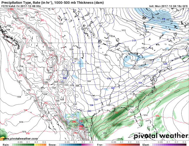
NOW, with the Temperatures out of the way. I've been seeing TWO interesting things about the projections for this weekend. The two things that caught my attention were one disturbance that will be passing by Thursday Night into Friday Morning..... As You know from the above paragraphs the temperatures will be within that Rain/Snow/Mix Threshold. SO, the disturbance moving through Thursday night into Friday is MOISTURE STARVED, but the models have been fairly consistent with some Light precipitation overnight Thursday and into Friday morning......... NOW, by "Light" I mean SNOW FLURRIES! The first chance on Thursday night into Friday will be mainly for North Central Arkansas, and PARTS of Central Arkansas. See Below.

This is the GFS for Thursday Night into Friday Morning. Now this doesn't show a chance for a band of snow or anything, but it does show a chance for LIGHT FLURRIES!
There's not one, but TWO Chances of Flurries here in the State. The next chance is for Saturday Morning. Now this chance is mainly for Northeast Arkansas near the Arkansas/Tennessee Border. Once again, this map doesn't show a prediction of a band of heavy snow or nothing, but it does show a chance for FLURRIES!!!!

GFS valid Saturday Morning from 6am-12Noon. Show's chance for Light Flurries in Northeast Arkansas.
NOW, Let me remind you guys of something, WEATHER MODELS DO NOT PERFORM WELL WITH COLD AIR. So even though we are not that far away in time from the timeline of this forecast, that doesn't mean that something won't change. I can check the Midnight (00Z) Run of the Weather Models, and all of this could be a different story. But, at this time, this is what I expect for the rest of the week, and weekend. If You have ANY QUESTIONS, please don't be afraid to hit me up. Thank You for coming here to the Arkansas Weather Hawk's Blog!!!
Follow Me On Social Media
@Omarrian Wilson - Facebook
@OmarrWilson - Twitter
+The Arkansas Weather Hawk - Google Plus
@thearkansas_weatherhawk - Instagram


Comments
Post a Comment