Posts

Showing posts from 2015

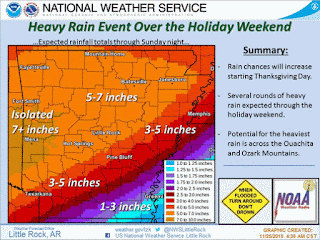
Late Holiday Weekend Flooding

Image
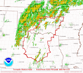
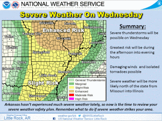
     Hey Good Day everybody, how's it going!! I hope everybody had a nice, and SAFE Christmas. I enjoyed mine, I'm sure I gained about 10 pounds from all that eating I'm STILL doing. Now getting past that, bc there's a lot we need to cover about the weather.     There was some pretty loud storms that moved through south and parts of central Arkansas this morning. I basically expect more of that in areas of the state for the rest of today, and tomorrow, on through Monday. In fact, the instability measures are quite marginal in West Arkansas, so there is a threat for an isolated tornado or two. There is also a Slight risk for Severe Weather in west Arkansas due to the probability of dangerous severe weather. A **TORNADO WATCH** has been issued by the Storm Prediction Center in Norman Oklahoma due to the possibility of Severe Weather.     As far as today go, I do NOT THINK there is a huge chance for an Outbreak of Severe Weather, however the instability Measures for area

Severe Weather, Christmas, More Severe Weather!!!!!

Image
     Good Afternoon everybody, how's it going!! I planned to do this weather update last night while I was at work but we got busy! But there is a Lot to cover so I'll jump right into things. I'll go in sequence of the Title. -Severe Weather. Okay so by now it's no secret that Tuesday, and into Wednesday there is a significant chance of rain associated with a front right? Kay so this front will be pulling moisture, and warm air up from the Golf Of Mexico. That means the AUTOMATIC chance for strong thunderstorms. The instability measures will be marginal to fairly present. So what this means is that there is a chance for elevated thunderstorms.... Now this system is due in the MORNING on Wednesday, the time of the day when the heating of the ground is the highest is the EVENING time, that's a rule. So with that said, Instability won't be as much as it COULD be. If these storms can get organized in an UNORGANIZED environment then they stand the chance of POSSIBLY

Preliminary Christmas Outlook

     Hey Good Evening Everybody, How's it Going! The big story weatherwise has been the unseasonably mild temperatures that we've been experiencing. Now in my last update I explained how I mainly think this is due to an extension of our Fall Season Overlapping into our Winter Season because it's come LATE this year just like everything else. Now although I know that kind of sounds a little bit "Off" compared to what other Forecasters are saying, and it doesn't necessarily fall in line with everybody else, but ARKANSAS WEATHER is out there! LOL! However, no matter how far fetched things may sound, all I can do is interpret the weather data, and the weather itself, and give you guys my interpretation of what I see. Nothing more or less. A lot of times I tend to be right, not all the time, but a lot of times. I just credit that to my natural ability to understand mother nature! But anyways, I digress, on to this Christmas!      Now it sees to me that there are T

Why A Warm Winter???

     Hey GoodMorning Everybody! I've gotten lots of questions about why it's been so warm and pleasant in winter time. It's Unusual to be this warm, but it's very simple as to why the weather is like this.      Okay so do y'all remember January-March of this year? It got COLD and we start to get hit and miss shots of Ice. Come March of this year we started having Snow Storms. The Strongest Snow Storm was Mid March, dropped about 4" here in the Little Rock Area, brought TOTAL WHITE OUT conditions, it was daytime, remember that? Winter was LATE right? Okay now remember it was cold all the way into LATE April, Early May right? Spring didn't kick in until Late May Early June Right?! Now Remember back in June when our "Spring" Kicked in during our "Summer" Season? We got HISTORIC FLOODING!!! Arkansas River Flooded out, overflowed. North Little Rock Flooded, Big Damn Bridge Flooded, Riverfront Flooded, and nearly a MILLION other places around

Wet And Soggy Sunday

Image
    GoodMorning everybody! How's it going.! I know it's been awhile since I've posted any weather updates, but that's mainly because there hasn't been anything to talk about. We are off into the Meteorological Winter, and it's Warm and MILD. 68° in DECEMBER! I told you guys in LATE JULY in a Weather Update that it was going to be a LATE SEASON. Everybody got excited by the Early Freeze we had in November but that didn't fool me, I stuck to my guns, and LOOK at what's going on!! WARM AND MILD! Doesn't feel like Winter at all, record high temperatures, I know my stuff. I just might be one of the best Amateurs out there. But ANYWAYS, I digress.      This next Weather Maker scheduled for Late Tonight and overnight, into, and throughout the day Sunday is similar to the system a few weeks ago where we got SEVERAL inches of rain, an bad flooding. Same type system, same type setup, only difference is; this setup doesn't have that deep of a trough feedin

Holiday Rain, Cold, and Flooding Weather Update 11/25/15

Image
       Hey everybody, how's it going! I hope you're better off than I am. Jumping right into things the major story with this holiday weather maker will be rainfall. There's a good chance for steady rainfall, so flooding will be a good chance. This WILL be a washout. Unfortunately, this weather maker will be a real downer on things. Just grab an umbrella, wear a jacket, and some pants, and you'll be fine. Now this rain will be associated with a frontal boundary, behind that boundary will be some colder air. Colder than it will be on Thanksgiving for sure. The models have the cold air moving through on Saturday, but weather models do a bad job predicting air, I think the air will tank south overnight Friday with some areas getting cold before daybreak on Saturday. *SAVE A PLATE FOR ME PLZ!!!! Here's a map courtesy of the National Weather Service in here in Little Rock of a corridor through the state of very heavy rainfall. Really good amounts of rain expected. Fl

Preliminary Thanksgiving Forecast 11/21/15

Image
     Hey Good Afternoon everybody, how's it going!! I was reviewing the weather models this morning and saw a few interesting things that will get us into the Christmas Holiday spirit. The temperatures will go ahead and make that winterly swing. I'm starting to see that transition from fall to winter in the weather patterns. Today is cold and windy right? Typical Winter day.  For the first time this year we've got a Freeze Warning In effect. I'll include a picture of it below. Freeze warning means it will be COLD, that means if you have sensitive Plants, any animals; cats, dogs, get them inside in some heat. If your pets freeze to death, it's a crime and you can go to jail. If you work outside, dress accordingly, the wind will be high, and it will be COLD. These are the expected Low temperatures for tonight!!! This is courtesy of the National Weather Service in North Little Rock. Low 20s to even TEENS in North Arkansas, upper 20s here in Central Arkansas. Low 30

SEVERE WEATHER UPDATE: Our Next Big Weather Maker

Image
     Hey Good Afternoon Everybody, how's it going. I'm going to TRY to condense this weather update as much as possible while not missing out on any information that you really need to know. It's just a LOT of Stuff.      Timing, at the moment, we are looking at chances for rain on Monday, a chance for Severe Weather throughout the afternoon-nighttime hours on Tuesday, and this stuff clearing east Arkansas by Wednesday.      Threats, right now the MAIN threats will be Strong damaging thunderstorm winds, Esp associated with the front itself. Heavy rainfall is my greatest concern. This System will have A LOT of precipitation. When I say a lot, I do mean LOTS of rain. Flooding is a given. The possibly does exist for isolated Tornadoes, Wind Shear, and Instability values will be high in certain areas which means that should storms organize out ahead of the front, tornadoes can be a real possibility. Tornadoes can also spinup within the kinks of the line itself. I STRONGLY adv

Wednesday Weather Worries

Image
                 HAPPY VETERAN'S DAY!!!!!       GoodMorning Everybody, how's it going! Well it sees to me, that our chances for severe weather has passed us by for today. NOT COMPLETELY, because any storms that do develop in South or Northeast Arkansas will have the potential to organize and cause a wind threat, a hail threat, and possibly a low tornado threat. People I need you guys to understand something, weather forecasters are not Gods. God did NOT give us a higher power allowing us to see into the future and foresee what will happen (With the Weather), unfortunately we don't have that ability. Now based on a varied amount of interior and exterior factors our forecast models are somewhat able to give us clues as to what the future holds, weather wise, but they are not always right!!! Weather Models "Fine Tune" themselves as we get closer in time to a weather event giving us a more accurate picture of what to prepare for. Nothing more, or less. So I might see

Veteran's Day Rain, Storms, and Possible Tornadoes

Image
     GoodMorning Everybody, How's it going! Severe Weather Update here, this morning I took a look at the new model data. The Storm Prediction Center in Norman Oklahoma has lifted the "Enhanced" Risk into Missouri, as time go by I'm thinking this is turning into more of an Isolated Threat than a Widespread threat. However, the threat still remains for the organization of Supercell Thunderstorms, they will have the ability to quickly organize and state to rotate, then become tornadic. So Certain areas of the State will have a substantial threat for Dangerous storms and possible tornadoes. Mainly this is a Strong Wind threat type of system, but due to speed, and rapid intensifying, they can present a tornadic threat. Here's a Forecast and a map developed by the National Weather Service in North Little Rock. As you can see, this is a more generalized wind threat than tornadic, but due to speed and possible rapid intensification, Tornadoes can't be ruled out,

Wicked Weather Wednesday !!

Image
     Hey Everybody, how's it going!  This is a Severe Weather Update for Veteran's Day, Wednesday November 11th, 2015. This is a particularly Important Weather Update due to the sense of seriousness associated with this front. See the Instability variables in the atmosphere itself in Arkansas won't be that great. But the issue is, this system will move through with force and something called Momentum. This system will be fast moving, the storms that are able to organize will quickly whip up and start to spin, all due to Speed and Direction, "Momentum." The Storm Prediction Center in Norman Oklahoma has already issued a Slight-Enhanced Risk for Severe Weather. "Enhanced" risk for severe weather means there is a raised level of concern within a certain area. See, there's a slight risk for Severe Weather for a large area within the state, but there is an Area within that area where there is a Elevated level of concern for severe weather. That's what

Weather Update: Severe Weather Update 11/5/2015

Image
      Hey GoodMorning Everybody, how's it going! I've just looked at the Newest runs of the weather models, and I'm pretty much still in line with everything I said on the last update. Nothing has necessarily changed. Before I go any further, I gotta say, I'm VERY appreciative of all the support from you guys, and I'm very honored that everybody comes here to the Hawk's blog for weather information. Now, getting past that, on to today/ tomorrow.      When it comes to what we are looking at in terms of threats, I'm thinking Damaging thunderstorm winds (Straight Line Winds), and the possibility of large hail. Isolated tornadoes are a possibility, I would NOT rule out a brief spinup tornado somewhere along the squall line as it moves through. NOW, with that said, this WILL NOT be a widespread severe weather event. The last update I released kind of scared a few people. That was not my intention, I just want to make you guys aware that the possibility exist, no

Weather Update: Severe Weather Update 11/4/2015

Image
     Hey Everybody, how's it going. This is a very important weather update, I need you guys to read over this very carefully.. There is a chance for Severe weather on Thursday November 5th. Now the risk are possible large hail, high damaging thunderstorm winds, and isolated tornadoes are all  possibilities. I'll cover what this means and where.       As far as where, the area with the best chance for severe weather is going to be Southwest, West, and into Central Arkansas. In a Corridor from Fort Smith to Texarkana to Hot Springs Village, and up the I30 corridor from Texarkana to Little Rock, up 67/167 to Cabot, down I40 to Carlisle to Brinkley. I'm VERY sure tomorrow some point during the day, the Storm Prediction Center in Norman Oklahoma will issue a watch of Some type for that outlined area. In terms of what to expect, we are looking at an Isolated chance for tornadoes. The way this will come in is in the form of a Squall Line, the problem with Squall Lines is when th

Weather Update: The Rain Chances Remain

         Hey Everybody, how's it going! Well the rain chances appear to remain steady. As I watch the Weather models day by day, I see a every other day trend going on here. What I mean by that, it rain a day or two, dry out for about 3 days, then we have another chance for rain. That's good news when it comes to improving our drought conditions. Breaking ground in that is always  good thing as long as it remain steady and we don't get too much at once.      Now The latest run of the GFS (Global Forecasting System) is doing a great job picking up the moisture of this tropical system that we have delt with since yesterday morning. It should start to lift off to the north, and be gone by later today entirely. According to the GFS Wednesday, North Arkansas has a chance for Stray showers and rain, more than one model picks that up. Now the GFS is fairly consistent with a great chance of rain from Friday Night - Sunday. With everything starting later Friday Night, and raining t

When it FINALLY Rain's it POURS!

Image
       Hey Everybody, How's it Going!! We finally for the first time in months have managed to get some good, SOLID rain that means anything to our drought conditions that has been going on. Our drought has made history for this particular time of year. Now we have relief. But here lies the problem, you see there's an old saying "When it Rain's, it pours." That old saying is what came to mind when I took a look at the weather pattern over the next week. See this feed of moisture that we've had over the last few days will be moving eastward. But we still have unfinished business.       The remains of what was once Hurricane Patricia, have moved through most of Mexico, and will soon be entering the Golf of Mexico. Thankfully for us, it won't be a Hurricane, it will be a tropical system. Once this tropical system of moisture moves inland, it's trajectory will take it roughly along the Mississippi/Alabama border, which will put the " Blow Off" o

Drought RELIEF &MORE

Image
        Hey guys, how it going!? Remember last month I told everybody that our fall would be SLOW and DRY. I said it would be uneventful, at least the START of fall anyways. I told you guys that I didn't expect our fall to kick in until LATE in the season! What seems to be happening!? Where did I get ny predictions from you ask? Well, that just a happy sailor's secret. But however, I KNOW MY STUFF! This is why I chose to pursue a Weather Career, because I be on the money, but I digress. This has been one of the DRIEST Falls so far, HIGH Wildfire danger, serious burn bans. I'm talking DANGEROUSLY Dry conditions. You know it's dry when Farm machinery catch on fire just because it's dry, WHO'S EVER HEARD OF THAT??? Stuff like that happening that means it's serious.         Well Not to worry, we have relief coming within the next 24-48 hours. Our relief comes from a different source rather than a system. This source is more of a setup than a system. Basically i

And FALL BEGINS!!!!

Image
Say Hello to Fall 2015!!! Good Evening everybody! Even though today September 23rd, 2015 didn't feel like a normal Fall day in Arkansas, it's the meteorological start of Fall. We brought in Fall, and closed out summer with temperatures in the low 90s. Lol. I said in a blog post a few weeks ago that fall would start warm. We will be warm-mild for much of the first half of Fall. Honestly I don't expect it to rain much in the state for the next week. We do have a SLIGHT chance for SPRINKLES this weekend, but it won't mean nothing what so ever. Next week we will have a better chance for rain, but even that won't be enough to cause a major difference in the drought conditions throughout the state. So just enjoy the mild and dry conditgions. Get out and have fun family activities. Thank You guys for coming to the Arkansas Weather Hawk's Blog for weather information.! Follow Me on Social Media  TheArkansas WeatherHawk - Facebook  @OmarrWilson - Twitter   Th

The Drought Continues

       GoodAfternoon Everybody, how's it going! Just got done looking at the model data. Looks like the drought we have going on here in the state will continue with little relief. All of the Weather Models have an agreement on some rain chances this coming weekend, most agree on Saturday. But don't hold your breath, from what I'm seeing it's only a weak, and somewhat limited system, and it's only going to bring PARTIAL relief to North Arkansas. As it advances southward into the state, it breaks apart. At least that's the picture that the models are painting for the most part. We just need a great day long downpour of rain to wash all the dust off, and take our lawns off life support. Unfortunately there's a lot of dense dry air sitting in this area of the country, so the odds of that happening is kinda slim a this point. Things will for the mos part remain dry, and quiet. It will be mild-hot. I'm a winter baby that was born in a cold state, and cold cit

I Know My Stuff!!! I LOVE WEATHER!!

    GoodMorning Everybody, so about a week ago, I made a Blog post "Out of Hibernation". In that post I kinda broad stroked my preliminary opinions about this coming winter, it's Impact, it's timing, and how active. Now I said in that preliminary opinion that I thought it would be late and mild. Now as we are getting closer in time, and I'm starting to look more in dept into the dynamics of the climate heading into the 2015-16 Winter Season it's looking more and more like I'm RIGHT. I didn't get my opinion from any particular climate variable, I just stated how I felt about this coming winter based off of the Vibe that I've gotten this year Weatherwise.           Winter's Expected Timing, I expect this to be a LATE winter. For two reasons. 1. Being that every season we've had this year has been Late. The Winter was Long last year meaning it ran LATE into EARLY spring. Spring didn't kick in until LATE Spring. Spring Spilled over into s

OUT OF HIBERNATION!!!!!!

  Hey Everybody HOW IS IT GOING!!! It is I Omarrian Wilson (The Arkansas Weather Hawk). It's been a while since I've posted here on the Blog aye!! I didn't forget about the blog, I've actually been coming up with more imformal ways to broaden it's use. I'm going to do random articles on different things (Weather Related of course.) So I'll be getting back heavy on the Blog, I promise, and hopefully everybody will enjoy reading and coming here to the Weather Hawk's Blog. I enjoy spreading knowledge and the extensive research I've done on different subjects. I enjoy hearing everybody's opinions, views, and questions. I Love Questions.    Getting on past that, here in Arkansas we are FINALLY starting to come out of that DEAD summer Weather Pattern and get into the transition of fall. Slowly but surely the Seasonal transition is starting to commence, it's almost September. The Time has FINALLY Come. Now as far as this fall goes,  I do believe th

Welcome To The Arkansunna!!!!!

Image
     Welcome to the Arkansas Desert!!!! The place where temperatures rise with no relief or clouds to stop them. LOL. But all Jokes aside, guys it's DANGEROUSLY Hot outside. The Heat index is 100°+ in most areas. A Heat Advisory is in effect for a major part of the state for the better part of the week. Your forecast is a chance of Heavy Sun shine, with a 100% chance of extreme HEAT!!!   Here's a forecast Courtesy of the National Weather Service in North Little Rock. This is the Expected Heat indexes around the state. This is REALLY Hot weather Folks. It's DANGEROUSLY Hot outside. This is the reason why there are Heat Advisories everywhere.  Here's some Heat Safety Tips. DRINK LOTS OF WATER!!! Esp if you are messing around out doors. Drink as Much Water as you feel you need to. Carry Lots of Liquid with you. Gatorade, Powerade are also GREAT Drinks that can put those Electrolytes back into your body!! DO NOT DRESS IN LAYERS!!! Jeans are fine but do NOT wear m