Severe Weather, Christmas, More Severe Weather!!!!!
Good Afternoon everybody, how's it going!! I planned to do this weather update last night while I was at work but we got busy! But there is a Lot to cover so I'll jump right into things. I'll go in sequence of the Title.
-Severe Weather. Okay so by now it's no secret that Tuesday, and into Wednesday there is a significant chance of rain associated with a front right? Kay so this front will be pulling moisture, and warm air up from the Golf Of Mexico. That means the AUTOMATIC chance for strong thunderstorms. The instability measures will be marginal to fairly present. So what this means is that there is a chance for elevated thunderstorms.... Now this system is due in the MORNING on Wednesday, the time of the day when the heating of the ground is the highest is the EVENING time, that's a rule. So with that said, Instability won't be as much as it COULD be. If these storms can get organized in an UNORGANIZED environment then they stand the chance of POSSIBLY producing very strong winds or EVEN a Tornado or two... That prediction is based off the wind profiles and instability, and windshear measures. This does NOT mean there will be widespread Severe Weather, It just means there will be some strong storms, the possibility of them going Severe!
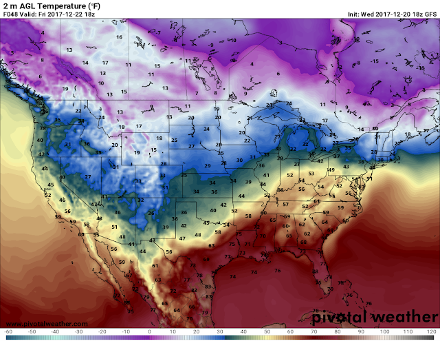
-CHRISTMAS! Christmas will probably start off like any other morning we've had recently, fairly chilly. But it will get warmer and warmer throughout the day climbing through the 50s and most of the 60s. Christmas will actually be quite pleasant. There is a chance for scattered showers later that day however. But Christmas will be warm enough for Santa to have on Gym shorts and flip flops!
-This Weekend! Following our pleasant Christmas holiday, Saturday and Sunday there is yet ANOTHER chance of rain and Severe thunderstorms. The Instability measures for that system will be stronger than the measures for this system coming in tomorrow night! So AT THIS TIME there is looking like more of a chance for Severe Weather this weekend. NOW, once the weekend system moves through, by Monday of next week roughly. There is ONE weather model that is picking up on some frozen precipitation on the BACK SIDE of that system. That would be wrap around moisture within the cold air that will be trailing the system itself.... I won't digress on that, we'll freeze that bridge when we get to it.
This is the Windshear map, it measures the amount of twist in the atmosphere. This is the GFS (Global Forecasting System) Weather Model. This is Valid at 6 and 9am Wednesday morning. Highest instability measures move in from the southwest up the I-30 Corridor Northeastward through the state. Any chances for severe weather and concern, you're looking at it! This could be much worse if it was moving in during the evening hours.
Okay, here's the precipitation map of the GFS weather model, this is valid at 6pm Christmas Day evening. It show's scattered showers starting to filter into southern Arkansas.
Here's the GFS by 12am Saturday Morning. As you can see there's a chance for rain overnight Christmas night/Saturday morning. Looking at rain until Monday honestly.
I know this was a LOT! I tried to srink it as much as possible, but it was a lot of information. I APPRECIATE everybody that made it to the bottom of this update, and read everything! Thank You for coming here to the Weather Hawk's Blog!
Follow Me On Social Media
TheArkansas WeatherHawk - Facebook
@OmarrWilson - Twitter
The Arkansas Weather Hawk - Google Plus


Comments
Post a Comment