Late Holiday Weekend Flooding
Hey Good Day everybody, how's it going!! I hope everybody had a nice, and SAFE Christmas. I enjoyed mine, I'm sure I gained about 10 pounds from all that eating I'm STILL doing. Now getting past that, bc there's a lot we need to cover about the weather.
There was some pretty loud storms that moved through south and parts of central Arkansas this morning. I basically expect more of that in areas of the state for the rest of today, and tomorrow, on through Monday. In fact, the instability measures are quite marginal in West Arkansas, so there is a threat for an isolated tornado or two. There is also a Slight risk for Severe Weather in west Arkansas due to the probability of dangerous severe weather. A **TORNADO WATCH** has been issued by the Storm Prediction Center in Norman Oklahoma due to the possibility of Severe Weather.
As far as today go, I do NOT THINK there is a huge chance for an Outbreak of Severe Weather, however the instability Measures for areas of west Arkansas is supportive for a Tornado or two. That is IF Storms are able to get organized.
Now getting pass that, on to Tomorrow! There is a substantial threat for Severe Weather in Central and South Arkansas tomorrow as these disturbances move through. There will be two waves of moisture. According to the weather models there will be on disturbance that will move through during the day, there is a severe threat with that, which is mostly a WIND and FLOODING threat. Then there will also be a threat with the front itself as it move through LATE in the day/night on Sunday. Again, I think the main threat will be WIND and HEAVY RAINFALL. There is a Tornado Threat Present with the front itself, anytime a front with a lot of wind energy, moisture, and lift comes through, there's always a chance for isolated tornadoes. That threat is Low-Marginal at best. The main concern here is WIND, AND FLOODING.

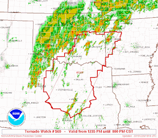
Here's a Picture of the Tornado Watch that has been issued by the Storm Prediction Center for far West Arkansas, mainly the Fort Smith and Surrounding Areas. Tornado Watch means conditions are supportive for the development of deadly weather. That Tornado Watch is valid until 8pm today.

Now this particular weather model is the GFS ( Global Forecasting System) weather model. It's a screenshot, so you'll have to click the picture and zoom in to see Arkansas. But this particular model show's scattered showers and storms in West Arkansas around 3pm during the day tomorrow.

See the GFS is Slow to move this system through, the GFS don't show it moving through until overnight Sunday and into the wee hours of the morning on Monday. The NAM weather model slows it down even more. The GEM model is overnight Sunday, in between Midnight Monday Morning, and 3am getting everything through. So the models disagree on timing whether it's cleared through by morning rush hour on Moday or not, so we'll see about timing. But however all the models agree on heavy rainfall.
Remember if you see standing water on the road, TURN AROUND, DON'T DROWN. SLOW DOWN YOUR SPEED, when you are driving in rain. KEEP 1 CAR LENGTH in between you and the cars around you!
I appreciate EVERYBODY for coming here to the blog and reading my weather updates. If you have any questions, plz don't hesitate to ask. Like, and Share!!
Follow Me On Social Media
TheArkansas WeatherHawk - Facebook
@ Omarr Wilson - Twitter
The Arkansas Weather Hawk - Google Plus


Comments
Post a Comment