Posts

Showing posts from November, 2015

Holiday Rain, Cold, and Flooding Weather Update 11/25/15

Image
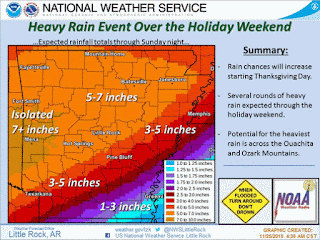
       Hey everybody, how's it going! I hope you're better off than I am. Jumping right into things the major story with this holiday weather maker will be rainfall. There's a good chance for steady rainfall, so flooding will be a good chance. This WILL be a washout. Unfortunately, this weather maker will be a real downer on things. Just grab an umbrella, wear a jacket, and some pants, and you'll be fine. Now this rain will be associated with a frontal boundary, behind that boundary will be some colder air. Colder than it will be on Thanksgiving for sure. The models have the cold air moving through on Saturday, but weather models do a bad job predicting air, I think the air will tank south overnight Friday with some areas getting cold before daybreak on Saturday. *SAVE A PLATE FOR ME PLZ!!!! Here's a map courtesy of the National Weather Service in here in Little Rock of a corridor through the state of very heavy rainfall. Really good amounts of rain expected. Fl

Preliminary Thanksgiving Forecast 11/21/15

Image
     Hey Good Afternoon everybody, how's it going!! I was reviewing the weather models this morning and saw a few interesting things that will get us into the Christmas Holiday spirit. The temperatures will go ahead and make that winterly swing. I'm starting to see that transition from fall to winter in the weather patterns. Today is cold and windy right? Typical Winter day.  For the first time this year we've got a Freeze Warning In effect. I'll include a picture of it below. Freeze warning means it will be COLD, that means if you have sensitive Plants, any animals; cats, dogs, get them inside in some heat. If your pets freeze to death, it's a crime and you can go to jail. If you work outside, dress accordingly, the wind will be high, and it will be COLD. These are the expected Low temperatures for tonight!!! This is courtesy of the National Weather Service in North Little Rock. Low 20s to even TEENS in North Arkansas, upper 20s here in Central Arkansas. Low 30

SEVERE WEATHER UPDATE: Our Next Big Weather Maker

Image
     Hey Good Afternoon Everybody, how's it going. I'm going to TRY to condense this weather update as much as possible while not missing out on any information that you really need to know. It's just a LOT of Stuff.      Timing, at the moment, we are looking at chances for rain on Monday, a chance for Severe Weather throughout the afternoon-nighttime hours on Tuesday, and this stuff clearing east Arkansas by Wednesday.      Threats, right now the MAIN threats will be Strong damaging thunderstorm winds, Esp associated with the front itself. Heavy rainfall is my greatest concern. This System will have A LOT of precipitation. When I say a lot, I do mean LOTS of rain. Flooding is a given. The possibly does exist for isolated Tornadoes, Wind Shear, and Instability values will be high in certain areas which means that should storms organize out ahead of the front, tornadoes can be a real possibility. Tornadoes can also spinup within the kinks of the line itself. I STRONGLY adv

Wednesday Weather Worries

Image
                 HAPPY VETERAN'S DAY!!!!!       GoodMorning Everybody, how's it going! Well it sees to me, that our chances for severe weather has passed us by for today. NOT COMPLETELY, because any storms that do develop in South or Northeast Arkansas will have the potential to organize and cause a wind threat, a hail threat, and possibly a low tornado threat. People I need you guys to understand something, weather forecasters are not Gods. God did NOT give us a higher power allowing us to see into the future and foresee what will happen (With the Weather), unfortunately we don't have that ability. Now based on a varied amount of interior and exterior factors our forecast models are somewhat able to give us clues as to what the future holds, weather wise, but they are not always right!!! Weather Models "Fine Tune" themselves as we get closer in time to a weather event giving us a more accurate picture of what to prepare for. Nothing more, or less. So I might see

Veteran's Day Rain, Storms, and Possible Tornadoes

Image
     GoodMorning Everybody, How's it going! Severe Weather Update here, this morning I took a look at the new model data. The Storm Prediction Center in Norman Oklahoma has lifted the "Enhanced" Risk into Missouri, as time go by I'm thinking this is turning into more of an Isolated Threat than a Widespread threat. However, the threat still remains for the organization of Supercell Thunderstorms, they will have the ability to quickly organize and state to rotate, then become tornadic. So Certain areas of the State will have a substantial threat for Dangerous storms and possible tornadoes. Mainly this is a Strong Wind threat type of system, but due to speed, and rapid intensifying, they can present a tornadic threat. Here's a Forecast and a map developed by the National Weather Service in North Little Rock. As you can see, this is a more generalized wind threat than tornadic, but due to speed and possible rapid intensification, Tornadoes can't be ruled out,

Wicked Weather Wednesday !!

Image
     Hey Everybody, how's it going!  This is a Severe Weather Update for Veteran's Day, Wednesday November 11th, 2015. This is a particularly Important Weather Update due to the sense of seriousness associated with this front. See the Instability variables in the atmosphere itself in Arkansas won't be that great. But the issue is, this system will move through with force and something called Momentum. This system will be fast moving, the storms that are able to organize will quickly whip up and start to spin, all due to Speed and Direction, "Momentum." The Storm Prediction Center in Norman Oklahoma has already issued a Slight-Enhanced Risk for Severe Weather. "Enhanced" risk for severe weather means there is a raised level of concern within a certain area. See, there's a slight risk for Severe Weather for a large area within the state, but there is an Area within that area where there is a Elevated level of concern for severe weather. That's what

Weather Update: Severe Weather Update 11/5/2015

Image
      Hey GoodMorning Everybody, how's it going! I've just looked at the Newest runs of the weather models, and I'm pretty much still in line with everything I said on the last update. Nothing has necessarily changed. Before I go any further, I gotta say, I'm VERY appreciative of all the support from you guys, and I'm very honored that everybody comes here to the Hawk's blog for weather information. Now, getting past that, on to today/ tomorrow.      When it comes to what we are looking at in terms of threats, I'm thinking Damaging thunderstorm winds (Straight Line Winds), and the possibility of large hail. Isolated tornadoes are a possibility, I would NOT rule out a brief spinup tornado somewhere along the squall line as it moves through. NOW, with that said, this WILL NOT be a widespread severe weather event. The last update I released kind of scared a few people. That was not my intention, I just want to make you guys aware that the possibility exist, no

Weather Update: Severe Weather Update 11/4/2015

Image
     Hey Everybody, how's it going. This is a very important weather update, I need you guys to read over this very carefully.. There is a chance for Severe weather on Thursday November 5th. Now the risk are possible large hail, high damaging thunderstorm winds, and isolated tornadoes are all  possibilities. I'll cover what this means and where.       As far as where, the area with the best chance for severe weather is going to be Southwest, West, and into Central Arkansas. In a Corridor from Fort Smith to Texarkana to Hot Springs Village, and up the I30 corridor from Texarkana to Little Rock, up 67/167 to Cabot, down I40 to Carlisle to Brinkley. I'm VERY sure tomorrow some point during the day, the Storm Prediction Center in Norman Oklahoma will issue a watch of Some type for that outlined area. In terms of what to expect, we are looking at an Isolated chance for tornadoes. The way this will come in is in the form of a Squall Line, the problem with Squall Lines is when th