Weather Update: Severe Weather Update 11/5/2015
Hey GoodMorning Everybody, how's it going! I've just looked at the Newest runs of the weather models, and I'm pretty much still in line with everything I said on the last update. Nothing has necessarily changed. Before I go any further, I gotta say, I'm VERY appreciative of all the support from you guys, and I'm very honored that everybody comes here to the Hawk's blog for weather information. Now, getting past that, on to today/ tomorrow.
When it comes to what we are looking at in terms of threats, I'm thinking Damaging thunderstorm winds (Straight Line Winds), and the possibility of large hail. Isolated tornadoes are a possibility, I would NOT rule out a brief spinup tornado somewhere along the squall line as it moves through. NOW, with that said, this WILL NOT be a widespread severe weather event. The last update I released kind of scared a few people. That was not my intention, I just want to make you guys aware that the possibility exist, nothing more.
As far as timing is concerned, It's still looking like overnight hours into tomorrow morning. The reason why I was so animated in my last update is because, Severe Weather tends to kill the most people in the evening rush hour, and overnight hours. Those are the two times within the day that people are the most unaware of what the weather is doing. This system will move through overnight, High Winds tend to blow over trees and kill people in their houses, tornadoes presents obvious dangers to people that are sleeping, or unaware. Its my job to provide awareness. Below are some weather maps depicting the expected timing of this system, and the threats it posses.

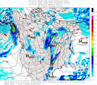
Okay now here's a shot of the GFS (Global Forecasting System) weather model, what you're looking at here is the 6am 11/5/2015 run of this model, it shows a squall line (Line of thunderstorms) moving across the state overnight Thursday, and into Friday morning. Now the main threats with this will be DAMAGING WIND, and Large Hail, with Heavy Rainfall. I wouldn't rule out a BRIEF Spinup in South Arkansas as the Line initially moves in. That's my main concern in terms of Tornadoes.

Here's that same model, the GFS this shot shows the timeframe in between midnight, and 6am. It shows the main line moving through central Arkansas within that timeframe. Again the main threats I expect with this WILL BE WIND, HAIL, AND RAIN. I will be in my office, tracking the system looking for anything that looks tornadic, but I'm not expecting much Tornado weather, however it still can't be rule out.

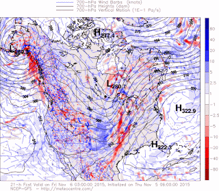
Now here's the GFS weather model, but a different map. This is the Vertical Motion Index, it measures the amount of lift in the Atmosphere, this is overnight on tonight around 3am, it shows the most instability associated with the line itself. That's where our wind threat comes from. With the speed of the system itself, spinups could originate within the kinks of the line itself, but again, that's not a very high probability.

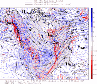
This is in between 3-6am it shows abunch of Wind associated with the line itself moving through. Now Honestly I expect the system to speed up and move through alil quicker, and earlier, but never the less that wouldn't change the circumstances of the entire thing. As weathe moves in I will have CONSTANT updates on Social media of how things are going and the progression of this system. If anything happens or touches down, I'll have updates about it on social media. If any watches or any warnings what so ever go out, I'll update about that as well. So I strongly advise everybody to follow me on social media. I really appreciate everybody for coming here to the weather hawk's blog.
Follow Me on Social Media
TheArkansas Weather Hawk - Facebook
@OmarrWilson - Twitter
The Arkansas Weather Hawk - Google Plus


Comments
Post a Comment