Posts

Showing posts from February, 2018

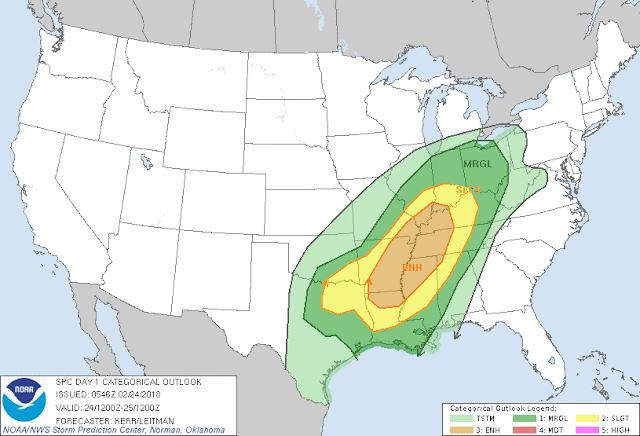
More Severe Weather? Or Nah? My Thoughts?

Image
     Hey Good Evening everybody! How's it going?  I hope everybody is safe and well after Saturday's storms! I know there was 1 death in far North Arkansas in Clay county along the Missouri border. That death was during 1 of 2 Tornadoes reported on Saturday during that Severe weather event. Arkansas is in the top 5 of the states in the south with the most Tornado related fatalities! Now this statistic doesn't come as much of a surprise to me because I know that people here in Arkansas don't take weather seriously. Severe Weather and Tornadoes are a big joke to a lot of stubborn people here in Arkansas, and that's mainly due to the lack of education on how dangerous these storms can be, and/or the lack of preparation. When Severe Thunderstorm Warnings or Tornado Warnings go out for your area, IT IS REAL...This stuff is not a game, it's not a joke, I don't do these updates to stay in shape, I do it because it's SERIOUS, and these updates contain informatio

**SEVERE WEATHER UPDATE** Severe Weather Saturday

Image
     Hey GoodMorning Everybody! I hope everybody had a safe day yesterday, there was well over two dozen accident reports across Central Arkansas. I hope everybody that follows my weather, and visits the blog took my advice and drove safely. Yesterday did exactly what I said it would do by just adding on to our rain totals making them way worse in areas that do NOT need anymore rain. Today (Saturday, February 24th) will be no different, only exception with today is the fact that we will have Severe Weather, and Tornadoes to deal with!      Now how bad is it going to get? And where?..... Well just like I stated yesterday, we will have a front that will move through today and put an end to the deluge of rain we've been getting. But with that front will come the chance for Severe Weather due to the increase in warm moist air that will meet with this front over Arkansas. The warm air will be most abundant and unstable on the EAST side of the I30 Corridor, so from Little Rock to points

FIRST ***SEVERE WEATHER UPDATE*** OF 2018 !!!

Image
     Hey everybody, how's it Going! This has been a very rainy week here for the entire state! We've REALLY needed the rain coming out of a fairly dry Fall, and mostly dry Winter to be honest. BUT, what we didn't need was all that rain at ONCE. So now, we have a serious Flash Flooding issue, this is SO serious to the point to where a School District here in Central Arkansas has cancelled classes for the remainder of the week just due to county roads along the bus routes being completely flooded out! This comes after a school bus and it's occupants had to be rescued because the school bus lost the road while traveling through flood waters. So since then the entire district has cancelled classes. You know the problem is LEGIT when the School District takes a Weather Day when it's not even Winter Weather Related! This nuisance rain comes from a front that moved in earlier in the week, stalled out to the south, and has allowed disturbance after disturbance to ride up al

Arkansas Winter Severe Weather Update 2/6/2018

Image
     Hey Everybody, How's it going!? Been a while since I posted huh!? I just like to keep the material weather. When there's nothing going on weather wise, I try to stay away from posting. But this evening, tonight, and into tomorrow morning there will be a storm system moving through and with it will bring a chance for both Storms and Winter weather. Generally south of I-40 I'm looking at chances for strong storms tonight. But, simultaneously North of I-40 there will be a chance for frozen precipitation, that being sleet. For some areas in FAR North Arkansas there may possibly be a change over to snow, or a mix. Now for Little Rock, and surrounding areas, I'm looking at above freezing temperatures throughout the evening and night, so I'm thinking just a chance for a cold rain here and points south. See Pictures Below: Now this is the NAM (North American Model) it is valid between the hours of 10pm and Midnight, and as you can see there's at least according