Arkansas Winter Severe Weather Update 2/6/2018
Hey Everybody, How's it going!? Been a while since I posted huh!? I just like to keep the material weather. When there's nothing going on weather wise, I try to stay away from posting. But this evening, tonight, and into tomorrow morning there will be a storm system moving through and with it will bring a chance for both Storms and Winter weather. Generally south of I-40 I'm looking at chances for strong storms tonight. But, simultaneously North of I-40 there will be a chance for frozen precipitation, that being sleet. For some areas in FAR North Arkansas there may possibly be a change over to snow, or a mix. Now for Little Rock, and surrounding areas, I'm looking at above freezing temperatures throughout the evening and night, so I'm thinking just a chance for a cold rain here and points south. See Pictures Below:
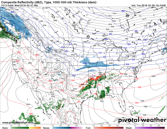


Now this is the NAM (North American Model) it is valid between the hours of 10pm and Midnight, and as you can see there's at least according to this one model the chance for sleet in North Arkansas, Looks like that area is generally North of I-40. Everywhere else to the South is a cold rain.

This is the NAM valid Wednesday morning, it shoves everything on out of here to the East. I don't really expect heavy Ice accumulations up North, generally under a 10th of an inch to be honest.

This is the NAM Temperature map shows mid 30s at the very onset of this, here in central Arkansas, but everybody to the North of Little Rock is at or below freezing which gives them the chance for good stuff. 40s to the south. 40-50 degree temperatures is not really a conducive element for Severe Weather or Tornadoes, so I'm not worried too much about that to be honest. But some strong storms are possible however.

Now this map here is the HRRR (High Resolution Rapid Refresh) Model, it's really good in the short range (12 hour period). This is the latest 12Z run of the HRRR, this picture is valid as late as 8pm tonight and it show scattered showers starting to pop up across Central Arkansas.

This is the HRRR though the overnight hours on Wednesday morning, and it shows a huge area of rain across the state ahead of the cold front, but unlike the EURO, NAM, and GFS Models, the HRRR doesn't show much of a chance for frozen stuff up North. But the HRRR is notorious for undercutting cold air as well, so it will happen, this model just isn't picking up on it much. But it does show Some frozen stuff in Northeast Arkansas, I'll give it that.

HRRR has this stuff in Central Arkansas but starting to shift on out to the East by early tomorrow morning. Still not much frozen stuff up north, ACCORDING TO THIS ONE MODEL.

This is a map and mini forecast courtesy of The National Weather Service in North Little Rock.
So obviously a few model differences, vast majority of them show frozen stuff fairly light, moderate in spots in North Arkansas, generally north of Interstate 40 with chances for moderate to heavy rain, and maybe a rumble of thunder for areas to the south of I-40. For the most part, that is what I expect to happen, a Winter Weather Advisory has gone out for the North half of Arkansas where the frozen stuff is expected. No Severe Weather watches or Alerts are in effect at this time. THANKS for coming here to the Arkansas Weather Hawk's Blog Everybody! Stay Safe!
Follow Me On Social Media:
@Omarrian Wilson - Facebook
@OmarrWilson - Twitter
+The Arkansas Weather Hawk - Google Plus
@thearkansas_weatherhawk - Instagram


Comments
Post a Comment