Posts

Showing posts from April, 2019

SEVERE WEATHER UPDATE: A SEVERE WEATHER SITUATION HERE!!

Image
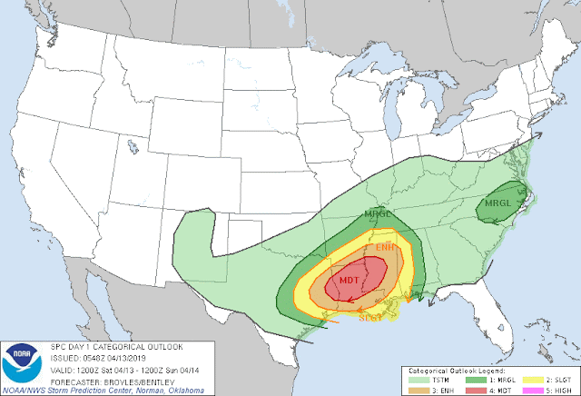
       Hey everybody, how's it going.!? I hope everybody is having a fantastic morning so far, and I hope everybody is safe in the rain this morning. You know, some people's driving is worse than others.... But anyways, speaking of rain, as you guys know we have us a little Severe Weather Situation going on up in here. There is a Chance for Widespread Severe Weather across SOUTHERN parts of the state, let's dive into it!       Okay so there's a Moderate Risk for Severe Weather in South Arkansas. There's a Low frontal system moving in from the South followed by cold air from the west/northwest, this sets the stage for a fairly strong level of windshear. Now there are Showers and Storms around at this hour (6:43am), in the morning, this will greatly diminish the level of Instability, thereby greatly diminishing the threat for widespread Severe Weather. BUT areas less touched like South Arkansas will still see a threat for Severe Weather. This is the Moderate Risk

SEVERE WEATHER UPDATE: Severe Weather Saturday!!

Image
       Hey everybody, how's it going!? I hope everybody is having a Fantastic day so far. From one storm system to another, this 2019 Storm Season has kicked in, and is in full effect!! This Weather maker coming in today is pretty legit, all Modes of Severe Weather will be possible. So make sure you guys have a way to receive information. This is the Morning Run of the HRRR (High Resolution Rapid Refresh) Weather Model. This particular model shows rain and storms moving in from the South. Scattered Storms in Central Arkansas, more concentrated storms in Southern Arkansas. This Image is Valid around 5pm this evening, with initial development around 3pm this evening. This should be gone and out of the State by midnight. No doubt about it, the highest threat for Hail, Wind, and Tornadoes will be in Southern Arkansas.  This map is Courtesy of the National Weather Service in North Little Rock. As you can see the Storm Prediction Center is thinking the same thing as they has issue

SEVERE WEATHER UPDATE: 4/03/19 Thursday Thunder

Image
     Hey everybody, I hope everybody is having a Fantastic night so far, and I hope everybody is safe. Over the last week, I've been watching a Storm System moving through tomorrow afternoon. The Main threats will be Limited Due to the timing of day, and the level of severity will be limited due to the lack of Instability. See Below.      This is a map courtesy of the National Weather Service in North Little Rock, as you can see here the Primary Threats will be Large Hail, and Damaging Thunderstorm Winds. Tornadoes cannot be ruled out, but are not likely.  This will not be a widespread severe weather outbreak. Mainly because this will come as two waves of moisture. The first wave of showers and storms will move through early in the morning on Thursday, SOME MAY BE STRONG. So for those getting up for work, and school, be aware of this. That first Initial wave will move through and leave lingering rain behind. This will cause cooling, and stabilize the atmosphere to keep Severe