SEVERE WEATHER UPDATE: A SEVERE WEATHER SITUATION HERE!!
Hey everybody, how's it going.!? I hope everybody is having a fantastic morning so far, and I hope everybody is safe in the rain this morning. You know, some people's driving is worse than others.... But anyways, speaking of rain, as you guys know we have us a little Severe Weather Situation going on up in here. There is a Chance for Widespread Severe Weather across SOUTHERN parts of the state, let's dive into it!
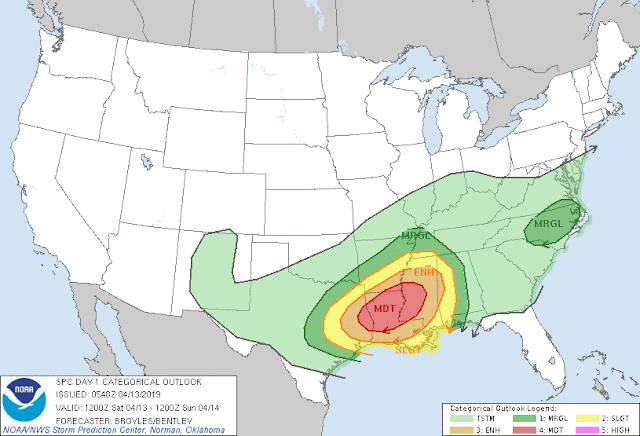
Okay so there's a Moderate Risk for Severe Weather in South Arkansas. There's a Low frontal system moving in from the South followed by cold air from the west/northwest, this sets the stage for a fairly strong level of windshear. Now there are Showers and Storms around at this hour (6:43am), in the morning, this will greatly diminish the level of Instability, thereby greatly diminishing the threat for widespread Severe Weather. BUT areas less touched like South Arkansas will still see a threat for Severe Weather.
Okay so there's a Moderate Risk for Severe Weather in South Arkansas. There's a Low frontal system moving in from the South followed by cold air from the west/northwest, this sets the stage for a fairly strong level of windshear. Now there are Showers and Storms around at this hour (6:43am), in the morning, this will greatly diminish the level of Instability, thereby greatly diminishing the threat for widespread Severe Weather. BUT areas less touched like South Arkansas will still see a threat for Severe Weather.
This is the Moderate Risk for Severe Weather, issued by the Storm Prediction Center in Norman, Oklahoma. They have shrunken the Moderate risk down to the south a bit taking a lot of South Arkansas out of it. But there is still a good chance south of Little Rock of Severe weather.
All Modes of Severe Weather are possible, and probable as we advance into Saturday evening. This system will move through as a Squall Line. Straight Line Wind Damage will be IMMINENT as the Line Moves through, Hail is Likely. Tornadoes can form within kinks in the Squall Line, so that's something we will have to watch out for very closely.
If any Storms develop out ahead of the main line, and showers are off to themselves, if they try to organize they will pose a imminent Tornado Threat to that area due to the wind energy in this system. As that Squall Line moves through, in areas of the state that get breaks in the clouds or rain during the day, will need to watch that line for possible "Spin Up" Tornadoes. PLEASE FOLLOW ME ON SOCIAL MEDIA FOR Updates on the Moment, as things happen!
Follow Me On Social Media
@Omarrian Wilson - Facebook
@OmarrWilson - Twitter
@thearkansas_weatherhawk - Instagram


Comments
Post a Comment