Posts

Showing posts from 2016

New Years Eve/New Years Forecast 2016/2017

Image
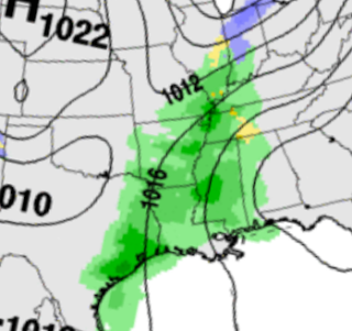
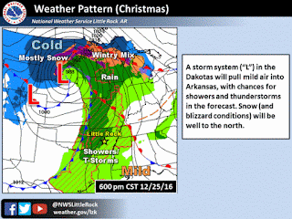
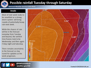
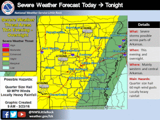
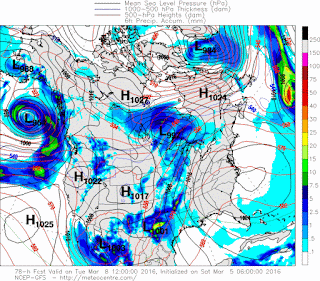
     Hey Everybody! How's it goin! I'm coming with an official Forecast for New Years Eve 2016/ New Years 2017. Everybody has been counting Winter out just because we had a Mild and HUMID Christmas, Last Christmas was Even More Warm than this one and not long after New Years Winter REALLY KICKED OFF! Now back in February of this year we had two Blizzards, the First one was NASTY! I was Caught in it... The Second was bad, but not as bad as the first one. I think the second was in March. Now, with that said, IN NO WAY do I think this will happen this winter, I'm just saying this to say that a Warm Christmas means Nothing! Now on to the Forecast below!      Okay, Starting with Wednesday (Tomorrow), There is a disturbance moving past the state so Showers (Scattered) are possible from Little Rock on South and East. NO SEVERE WEATHER EXPECTED, Just the possibility of Scattered Rain. Now heading into New Years Eve, there is a Storm System that will be gathering out of Texas and t

Christmas 2016 Weather Forecast

Image
     Hey everybody MERRY CHRISTMAS EVE!!!!  Im soo sorry I'm late with my update, I been busy Christmas Shopping, then food Shopping, and NOW COOKING! I'm doing this Update While waiting on my Pecan Pie to get done. So I have to make this Quick!      My official thoughts on Christmas Day, and Night. I don't think Christmas will be a COMPLETE Washout, I think in advance of the Front we have moving through showers will be spotted at best, and Isolated. But when the front move through Showers and storms will pick up. Y'all know the theme of this, Squall Line moving from Left to Right Across the State. I DO NOT, I REPEAT, I DO NOT expect much in the way of Widespread Severe Weather. I expect exactly what we've been getting. Moderate rainfall, Lightning and Thunder. I don't expect much bad weather with this. The parameters just aren't there.      Timing, as far as timing goes, I do expect the front to move through around Midnight or a tadd earlier. Scattered Sh

Severe AND Winter Weather Update 12/13/2016

Image
Hey Everybody, How's it Going!!  We have A lot to cover so I'm warning you now, this will be a lengthy Update.! So lets get right into it. This Past Weekend after all of our nice rain, we didn't get much in the way of flurries or snow at all, which was to be expected. But Saturday the Models started hinting on Possible Snow Next Weekend. Some Forecasters got all in a tissy on Social Media then people started talking about "Snow" for NEXT weekend which was THEN 7-8Days away! Let me tell y'all something people, NEVER, and I do mean NEVER BELIEVE a Person be it a Forecaster or any Weather Source when they say "There's a chance for Snow", But that Chance is 8 DAYS AWAY! Long Range Forecasting (Beyond 3-5 Days) is NEVER set in stone. Weather Models go as far out as 12 Days but Only the first 4 days of them are Credible You Understand me? So If it's beyond that 4 day period it's ONLY SPECULATION!!!!!!!! REMEMBER THAT!     Now that I got that o

Fairly Active, And Cold Weather Pattern To Come

    Hey everybody, How's it going!  I just want to say I hit a huge spike in viewers here on the Weather Hawk's Blog on my Weather Update from Yesterday. I SERIOUSLY Appreciate everybody for coming here to the Weather Hawk's blog for Weather Information. Now Let's get into our active Weather Pattern Shall we!?     First thing's first, I've been Looking at the GFS (Global Forecasting System)  weather model, and it's very cold on Wednesday Night, and into Thursday of This week. Possibly Freezing-Subfreezing Temperatures in West, and even into parts of Central Arkansas. The NAM (North American Model)  is ALSO showing the EXACT same thing! Now the Timing on the air according to the Models is Late Evening on Wednesday.... Here's my deal with that, WEATHER MODELS ARE NOT GOOD WITH COLD AIR! Cold Air is Heavier and more dense, so it falls towards the equator quicker than our Computer Models can calculate! I'd bet my Bottom Dollar that IF THIS VERIFY, it wo

Late November Severe Weather Update?!

Image
    Hey everybody, how's it going!? Y'all remember on Thanksgiving when I made a Weather Update to social media, I mentioned a chance for showers and thunderstorms this coming week. Well that chance has held true, In fact, there is Too much of a chance for rain then we NEED! More on that in a sec, but not to mention, this storm system is associated with a front, so needless to say that brings along a certain risk for severe weather! Strong Winds, Flooding, and ISOLATED Hail will be the main concerns BUT, the chance for Tornadoes IS PRESENT!  Not a Particularly Big/Great chance for Tornadoes, but it's NOT IMPOSSIBLE, even for this time of the year, IT IS ARKANSAS, ANYTHING is Possible!!! So, without further babbling on CHECK FORECAST BELOW! This Map is courtesy of   the National Weather Service here in Little Rock. The first Story here is WIND! Wind Gust up to 35mph in areas around the State as of Sunday Night. This is in part due to the strength of this storm system m

More Active Weather?? Dehydrated Fall? What's going on?

      Hey everybody, how's it going !!! Man this has been One DRY Season aye!! We haven't had very much rain since Early September! High pressure set's up and it's resilient, it hates budging! But now that the climate is now starting to switch into a cooler more Fall/Winter feel/vibe the rules to the game are changing. We have a Low pressure system that's making it's presence known in more ways than one! First, this system is bringing the FIRST BLIZZARD of 2016 to the Central United States Plains. Montana, Kansas, Nebraska, and South Dakota are in the cross hairs! Now we will be on the Other side of the stick when it makes it out this way!  We won't get no snow, but what we will get is a broken Line of Showers and Thunderstorms Late in the morning on Friday (Tomorrow), SOME OF THOSE STORMS COULD BE STRONG!      I Do Not Foresee a threat for Tornadoes or anything like that at this point. I do however, expect there to be some type of Strong Wind Threat presen

Tropical Arkansas!?!?!?!

Image
     GoodMorning Everybody! I know you're probably wondering what's up with my Title Lol. Well, I have something to share with you guys. Okay, so you remember last Post, I touched on the subject of the Atlantic Basin Hurricane Season activity picking up right.? Well turns out that I was actually right! It was more of a "Hunch" Comment if you will, that I made. I didn't want to say it because I was unsure about that feeling regarding the Hurricane Season because it's been soo long since we've had to discuss Hurricanes here in Arkansas. But there is a System developing in the Atlantics that is catching my attention......            ⇩↓▼      The last memorable Hurricane that even had a memorable impact on Arkansas was Hurricane Gustav in August of 2008. That was the last Major Tropical System that had a significant impact on Life here in Arkansas. NOW, WITH THAT SAID! I DO NOT THINK, this System will even be remotely close to that dramatic, especially for th

PRELIMINARY Fall&Winter Outlook&Thoughts

     Heyy Everybody! Long Time No Talk!! I just haven't found the need to post much because not much has happened other than our usual weather pattern.... We'll talk about that here in a minute. I was going to do this update Yesterday Night, but by the time I got my thoughts right, and organized it was too late. I then fell asleep, in which I have been for majority of this off day of mine. So now I'm just getting to the point @9:30pm to where I can type this thing out. Now that I cleared my chest. ▼↓↙       This Weather Pattern we've been in has been unusual for this time of year. You can attribute that to weaker high pressure than before. But because of that substantial lack of high pressure, the humidity levels have been AWFUL this year. Humidity is nothing but moisture...... That's it. Whether it's hot moisture, or cooler moisture. It's Moisture! Humidity is what makes it feel hotter than it is, humidity is what makes you sweat bullets! Humidity is when

Wet Independence Day Forecast !

      GoodMorning Everybody, How've you all been! I HOPE everybody has had a fair summer thus far! The weather has been very uneventful throughout the end of spring with just a few Scattered Severe Storms, nothing too out of the ordinary. The month of June was very dull, HOT, HUMID, and Uneventful. After going a Whole Month without substantial widespread rain, We are set to get Widespread Statewide Rain when we need it to be dry the most! 4th of July Holiday! I would've taken it raining Friday, Saturday, or even Sunday of our 4th of July Weekend, but NO! It wants to rain on the MAIN DAY! I'll explain the chances, as well as my full prediction below.         Okay so here's the deal, a front conveniently wants to make it's way out of the plains of USA and into Arkansas This morning, I'm typing this at 3:33am Local time, and the front is currently in Northwest Arkansas at this time. Now as this front move through it will somewhat slow down as it cross over the mou

Overnight/Early Morning Storms, Nothing Too Frightening

Image
     Hey Good Evening Everybody, How's it going! Everybody is somewhat scared from our last Storm System that came through on Monday/Tuesday. I just want to say THANK YOU!!! Thank You to EVERY LAST Human Being that came here to my Weather Blog, and THANK YOU to every last one of you on Social Media that follow my updates and warnings!!! THANK YOU TO EVERYBODY that support, and encourage me, and lastly THANK YOU to EVERYBODY that depend on me for information! THANK YOU!! You all are the reason I do this, and You all are the reason I've come this far! THANK YOU!!!!  Now that I got that out the way! On to Tonight, an Tomorrow!      Okay, so Later tonight a Storm System will move out of the plains and into Arkansas, this is a Unique one because it's not moving directly Left to Right (West to East) across the state, this one is moving Diagonally From Left/Top to Right/Bottom (Northwest to Southeast). So Northwest Arkansas will have a chance for Strong Storms Overnight Tonight,

*Monday Severe Weather Update*

Image
     GoodMorning everybody, how's it going! Just figured I'd do another update to keep you guys informed, the only thing that has changed is the risk area by the Storm Prediction Center in Norman Oklahoma. The way this will play out according to the Model data, storms will start to fire in West Arkansas, then into South Central Arkansas. Should Storms start to fire and get organized in this risk area, there will be Tornado Warnings with some, if not a lot of these storms. Now we have some rain about to move through, Im looking at the possibility of what we call "Evaporative Cooling" which in this process, the rain cooled air stabilizes the atmosphere limiting the formation, and organization of thunderstorms. That's something I'm looking at. But right now it's precips around, I'm looking for this stuff to blow off, and this evening for that system to move closer to Arkansas, and storms still start to fire out west. In sequential order they'll start

*Severe Weather Update** #MondayMadness

Image
    Hey everybody, how you doing! I hope you're having a good night so far, I hate to be the bear of bad news, but we have some serious weather moving in tomorrow. Here's the deal, there's what we call a "Dry Line" setting up in Oklahoma tomorrow. A Dry Line, is a boundary along the frontal boundary where strong to severe storms start to develop, and get dangerous. That's in Oklahoma, it's tamed for tonight, but by morning, and tomorrow afternoon, it will reintensify over East Oklahoma and start to move closer to West Arkansas.. Well the problem is, tomorrow storms will start to fire up out ahead of that front in areas of instability in West, and into Central Arkansas. Now, let's stop here... I DO EXPECT a Tornado Watch to go out Tomorrow Afternoon for West Arkansas, and a portion of Central Arkansas. If these storms manage to stay Isolated, and off to themselves within this area of instability in West and Central Arkansas, Tornadoes will be a Possibil

*Severe Weather Update** #WednesdayTroubles

Image
      Hey GoodEvening Everybody! I hope you're having a great day so far, Look I don't want to waste anytime digressing, very serious weather moving in, let's go All In! Okay so Oklahoma will get serious weather this evening, and tonight. They are under a PDS (Particularly Dangerous Situation) Tornado Watch... PDS Watches account for less than 2% of all Tornado Watches issued by the Storm Prediction Center. So when you see a PDS watch, that means it's BAD! BUT, that's Oklahoma, I have No reason to believe we will get one here in Arkansas.      Those Storms in Oklahoma will get close to and move over here towards Arkansas Later tonight, and overnight. Now by the time it gets HERE it will be a lot Weaker in nature so it won't be as bad. BUT, here's the Catch 22 to this, when the sun rises tomorrow, as it moves out of West Arkansas, and into Central Arkansas the Storms WILL REINTENSIFY. Okay, so let's play this Out....... Around 2am the Storms Start to cre

Mid Week Trouble!!!

Image
     GoodEvening everybody I hope everybody's having a well night so far. I just got done checking the evening run of the Weather Models, and it seems that we have some Typical Spring Weather coming by the Middle of the incoming work week. The Threats will be High Damaging Thunderstorm Winds, Large Hail, and Tornadoes are definitely possible! It's starting to become a bit clearer what's likely going to happen when this stuff comes in, let's break it down.      It looks like this will be a TYPICAL spring setup. For the public, that's not a good thing. Here's the deal, Tuesday night there will be a chance for Severe Weather in Far West Arkansas (Just some strong storms). The real threat is Wednesday. For West Arkansas, Wednesday Afternoon.... For Central Arkansas, Wednesday Evening. For East Arkansas, Wednesday Night! That's the expected timeline. Now when it comes to Severe Weather the chance really comes in later in the day as the Heating of the ground reac

Wet, Dry, Wet, Clear, Wet again!

Image
     Hey GoodMorning Everybody How's it going!! Just doing a weather update, I haven't done one in a while, and I miss my weather blog, I miss my weather page. I was feeling lonely. ! Seriously! I was feeling lonely without my true love (WEATHER). So I had to do a weather update, even if there's nothing to talk about, I still had to say something! But there actually is something to talk about, RAIN! We are once again getting bad flooding down in Texas right now. This time it's Houston. It's bad man, its real bad. At least from the flooding pictures, and video that I'VE SEEN! That is a CLASSIC EXAMPLE of what happens when you don't take care of LITTER, STORM DRAINS, AND LOCAL RIVERS AND CREEKS. You have to CLEAN UP what you MESS UP, otherwise the water fall out the sky and backup. This is how it goes. ! But we won't get nothing like that, we'll just get decent rainfall, which is what we need, wash some of that pollen away. Let's break it down.  

Overnight Storms

Image
     Hey everybody, how's it going! I hope you guys are having a good day so far. I know I haven't done any weather updates recently, haven't had much going on weather wise, and I'm in the middle of a busy work week, so I just haven't had time to do anything. But I'm making time today, because we have a storm system coming in overnight tonight, and into tomorrow morning. So lets take a dive into it aye.     As far as Timing goes, It's looking like Late this Evening in Oklahoma, Later tonight in West Arkansas, and moving left to right across the state during the Overnight Hours. So for Central Arkansas 12-2AM would be a good bet, and East Arkansas 2-7AM would be a good bet.     As far as what the threats are, well mainly due solely to the timing of the night this will move in, the MAIN threats are Hail, and Damaging Straight Line Winds. At First this was expected to move in during the Evening hours, and that raised some Tornado Concern among Meteorologist,

**SUNDAY SEVERE WEATHER UPDATE**

Image
      GoodMorning Everybody, How's it going.! As you likely know by now there is a developing weather situation later this evening for Arkansas. This severe weather threat comes from a quick moving storm system out of Oklahoma, and Instability out of North Texas. Those two mixed together presents us with the threat of severe weather.. In a Nutshell, Squal line develops this evening in West Arkansas, moves East into Central Arkansas into the Eveing/Nighttime Hours. Main Threats, Hail, damaging winds, Tornadoes ARE A POSSIBILITY with any ISOLATED storms that get organized. Primary Threat is Wind as it moves into East Arkansas later into the Nighttime hours. This is the Slight/Enhanced Risk area for Arkansas from the Storm Prediction Center in Norman Oklahoma. The slight risk is basically for the entire state, but there and "Enhanced Risk" (Raised Area Of Concern) for the Southwest corner of Arkansas.  This is a closer more in detail breakdown of what the risk for Se

WET WEATHER WEEK AHEAD!!

Image
     GoodMorning Everybody, I hope everybody had a safe night! I was planning on doing a weather update last night, but work wouldn't give me the time of day. I'm finally off! Anyways, on to the weather, there is A LOT to cover!      Okay First thing's first, this weekend will be awesome! Today, and tomorrow will be great. Get out, wash the car, wax it, go for a little cruise in your nice clean ride. Get out enjoy the weather, IT WON'T LAST LONG......      *Next Week, Okay so You know I study 3 Weather Models, NAM (North American Model), GFS ( Global Forecasting System), CMC (Canadian Weather Model). Now I look at and observe other weather maps, but my big 3 is those 3. Now all of the models agree on the Onset of this next BIG TIME weather maker.......TUESDAY. The Rain will start sometime during the morning hours on Tuesday. Overnight Tuesday, and into Wednesday there will be a frontal boundary setup and it will stall, and just sit over Arkansas. Wednesday morning a l

REMEMBERING MY GRANNY!!!! I MISS HER!

Image
     Hey everybody, how's it going. I'm dedicating a whole blog post to the memory of my late grandmother. It was 5 years ago today that I lost one of the most imperative women I've ever met in my entire life. This woman served one of the most influential roles of anybody that I've ever come into contact with.      When I was little, I had pretty much no father. My dad was known to my family in a very negative light that HE CAUSED. So I had no male or "Man" role models at an early age. All I've ever had was my Mommy and my 3 big sisters, they are responsible for the outstanding man that I am today, I owe it to them. But being the fact that my youngest sister is 9 years older than me, and my mom always slaved herself to death to get the bills paid, I had no immediate interaction with people.  My best friend was my DOG!!! All throughout my childhood years. Now Growing up, me and my grandmother didn't "Hit it off!" I didn't like her because