*Severe Weather Update** #WednesdayTroubles
Hey GoodEvening Everybody! I hope you're having a great day so far, Look I don't want to waste anytime digressing, very serious weather moving in, let's go All In! Okay so Oklahoma will get serious weather this evening, and tonight. They are under a PDS (Particularly Dangerous Situation) Tornado Watch... PDS Watches account for less than 2% of all Tornado Watches issued by the Storm Prediction Center. So when you see a PDS watch, that means it's BAD! BUT, that's Oklahoma, I have No reason to believe we will get one here in Arkansas.
Those Storms in Oklahoma will get close to and move over here towards Arkansas Later tonight, and overnight. Now by the time it gets HERE it will be a lot Weaker in nature so it won't be as bad. BUT, here's the Catch 22 to this, when the sun rises tomorrow, as it moves out of West Arkansas, and into Central Arkansas the Storms WILL REINTENSIFY. Okay, so let's play this Out....... Around 2am the Storms Start to creak into West Arkansas, there will be PLENTY Severe Thunderstorm Warnings, and MAYBE a few Tornado Warnings on the Kinks (Indentation areas along the leading edge of a squal line that contains rotating winds) of the Squal Line. BUT around this time, STRONG DAMAGING STRAIGHT LINED WINDS WILL BE THE MAIN THREATS HERE!! 60-70mph winds within Strong Storms are NOT UNCOMMON!! That is a Life threatening Situation if you're enroute to work and are unaware of the impending storms. Around 6-9am tomorrow Morning, the Storms will be moving out of West, and into Central Arkansas. Now as this stuff gets here to Central Arkansas EXPECT LOT'S OF SEVERE THUNDERSTORM WARNINGS!! There Will Likely be Storm Warnings Everywhere! As the Sun Comes up, and we get sunshine, the Chance WILL BE THERE FOR TORNADOES! I'm NOT expecting an outbreak, but there maybe Tornadoes. Around Noon- Evening, the Storms will move off to East Arkansas, there will be More of a Tornado and Severe Weather Threat over there with prolonged periods of Sunshine.
Now let me say this Now, there is nothing particularly uncommon about this Storm System, this is a very normal Spring Time Storm Setup for Arkansas. I'm not expecting a Large Tornado Outbreak, but the chance for Tornadoes is Present!

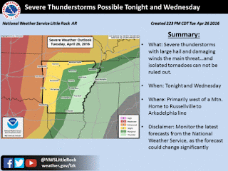
Here's a Map Courtesy of The National Weather Service in North Little Rock for Tonight. Primary area of Concern is West Arkansas, Enhanced Risk for Northwest Arkansas. Enhanced Risk means "Greater Area Of Concern Within a General Area of Concern." This Area of concern being primarily due to the intensity of the Storm System as they come from out of Oklahoma.

Here's are REALLY GOOD breakdown of the Expected Timing of the Incoming Storm System. Now the GREATEST AREAS OF INSTABILITY will be associated with the Squal Line itself. Due SPECIFICALLY TO THE TIMING OF THE DAY, the Instability Measures elsewhere will be low. But as this Squal Line moves out of West Arkansas and into Central Arkansas, it MUST BE WATCHED CLOSELY for Rotation within the "Kinks" of the Line itself. Brief Spinup Tornadoes from Squal Lines can be quite Strong, and pose a GREAT DANGER to the public due to the quickness of them, and the split second development. They can popup out of nowhere and be quite strong.

Another big story to this storm system, or series of Storms Systems is RAINFALL!! These Storms will bring an incredibly heavy amount of rainfall with them, and Flash Flooding will be a concern.
Now everybody I'm sorry if I got long winded on this update, but this is very important information. If you have ANY QUESTIONS after this update, PLZ comment, or message me, or call me, or whatever you need to do, I will answer any questions you may have. I will NOT be out Storm Chasing Unfortunately tomorrow, I have a Meeting in the Morning to Attend. I will be tracking the weather very closely, and I will get updates out promptly when I can, THAT I CAN PROMISE! Because of the fact that I will be in a meeting, I will advise you all to follow KARK Channel 4, and Fox 16 News, as well as me on Social Media for CONSTANT Updates on serious weather situations. FOR ALL THE STORM CHASERS THAT WILL BE OUT, BE SAFE, AND GET SOME FOR ME!!
Follow Me On Social Media
TheArkansas WeatherHawk - Facebook
@OmarrWilson - Twitter
The Arkansas Weather Hawk - Google Plus


Comments
Post a Comment