Mid Week Trouble!!!
GoodEvening everybody I hope everybody's having a well night so far. I just got done checking the evening run of the Weather Models, and it seems that we have some Typical Spring Weather coming by the Middle of the incoming work week. The Threats will be High Damaging Thunderstorm Winds, Large Hail, and Tornadoes are definitely possible! It's starting to become a bit clearer what's likely going to happen when this stuff comes in, let's break it down.
It looks like this will be a TYPICAL spring setup. For the public, that's not a good thing. Here's the deal, Tuesday night there will be a chance for Severe Weather in Far West Arkansas (Just some strong storms). The real threat is Wednesday. For West Arkansas, Wednesday Afternoon.... For Central Arkansas, Wednesday Evening. For East Arkansas, Wednesday Night! That's the expected timeline. Now when it comes to Severe Weather the chance really comes in later in the day as the Heating of the ground reaches it's peak. So Central And East Arkansas, this will come out of West Arkansas as a Squal Line. Anytime you have a Severe Weather Setup that includes a Squal Line, you have to watch storms out ahead of the Main line of storms. So like if the Line is in West Arkansas, and Storms start firing near Hot Springs Village, That's your tornado right there. Storm out ahead of the line off to itself, that's going to produce!! Now the threat for Severe weather will be higher in ANY AREAS OF THE STATE that see a prolonged period of Sun shine during the day on Wednesday. One thing to Note, this will be a fast moving line, and the main area of instability will be up and down the squal line itself. SO If I say there is rotation anywhere in the line, get ready to take cover. Tornadoes can spin up at a moment's notice in any little kink (indentation on the leading edge of the squal line). The line should exit out of East Arkansas close to Midnight on Wednesday Night/ Thursday Morning.
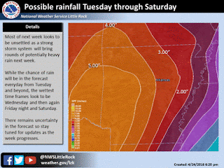
Another threat with all of this will be Flash Flooding. Anywhere from 3-5inches of rainfall could fall in a huge Central region of the state. See below.
It looks like this will be a TYPICAL spring setup. For the public, that's not a good thing. Here's the deal, Tuesday night there will be a chance for Severe Weather in Far West Arkansas (Just some strong storms). The real threat is Wednesday. For West Arkansas, Wednesday Afternoon.... For Central Arkansas, Wednesday Evening. For East Arkansas, Wednesday Night! That's the expected timeline. Now when it comes to Severe Weather the chance really comes in later in the day as the Heating of the ground reaches it's peak. So Central And East Arkansas, this will come out of West Arkansas as a Squal Line. Anytime you have a Severe Weather Setup that includes a Squal Line, you have to watch storms out ahead of the Main line of storms. So like if the Line is in West Arkansas, and Storms start firing near Hot Springs Village, That's your tornado right there. Storm out ahead of the line off to itself, that's going to produce!! Now the threat for Severe weather will be higher in ANY AREAS OF THE STATE that see a prolonged period of Sun shine during the day on Wednesday. One thing to Note, this will be a fast moving line, and the main area of instability will be up and down the squal line itself. SO If I say there is rotation anywhere in the line, get ready to take cover. Tornadoes can spin up at a moment's notice in any little kink (indentation on the leading edge of the squal line). The line should exit out of East Arkansas close to Midnight on Wednesday Night/ Thursday Morning.
Another threat with all of this will be Flash Flooding. Anywhere from 3-5inches of rainfall could fall in a huge Central region of the state. See below.

This is a rainfall map courtesy of The National Weather Service in North Little Rock, I think this is a pretty good prediction. Higher amounts in West/SouthWest Arkansas because of the system materializing, and starting to push off towards the East. Lesser Amounts in East Arkansas due to the Speed of the System by the time it reaches there. Still good totals never the less.
This is One full Work week away, but it's worth Mentioning. There is Yet another Round of Storms Projected by the long range models to come through on Friday Evening, and into Saturday. That system the moisture inflow comes from the southwest instead of the due west, so those storms will be coming out of North Texas, and into Southwest Arkansas, and move up the I-30 Corridor. Those storms do come with instability, so there's another chance for dangerous weather. Now that's one full week away, and we have Wednesday to worry about, so I'll be watching that, but let's get past Wednesday first.
Follow Me On Social Media
TheArkansas WeatherHawk - Facebook
@OmarrWilson - Twitter
The Arkansas Weather Hawk - Google Plus


Comments
Post a Comment