Posts

Showing posts from 2019

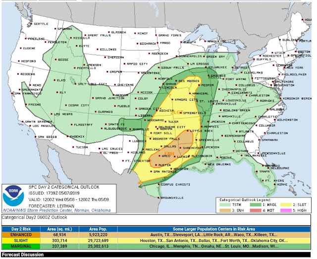
‼SEVERE WEATHER UPDATE 5/17/19: A SEVERE SATURDAY ‼

Image
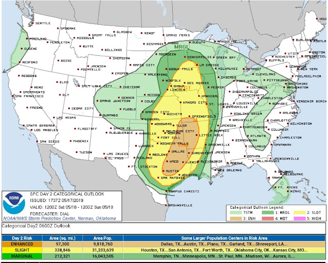
      Hey Everybody, how's it going!? I hope everybody is having a fantastic day so far because tomorrow will be not soo good for those that aren't having a good day today! So get your partying in because the weather will definitely put a damper on your day tomorrow no doubt!       So there is a Chance for a Severe Saturday shaping up for the state tomorrow. The threats for Hail, and High Water, and Winds are greater than the chance for Tornadoes. But however, there is a pretty substantial threat for Tornadoes tomorrow for West, and parts of Central Arkansas.      As far as Timing, the HRRR (High Resolution Rapid Refresh) Model shows everything coming through by tomorrow evening, and night. Tomorrow evening for West Arkansas, that timeframe set's a dangerous situation for West Arkansas, because that's the time of day, around 6pm when the heat of the ground is at it's peak. Tornadoes love that time of day for just that reason. As it get's later in the evening 8

SEVERE WEATHER UPDATE: Wicked Weather Wednesday!!!

Image
        Hey Good Afternoon everybody. I hope everybody is having a fantastic Afternoon today. If you're not, you may not have a good one tomorrow either. All Modes of Severe Weather is expected tomorrow. Below is everything you need to know so far.       The Storms will Initiate in West Arkansas at some point in the Wee/Early Morning hours on Wednesday Morning, and the Severe Weather Threat will gradually slide Northeast, and to the East as the day goes along. Like I said above, all modes of Severe Weather are expected during this setup. If you live in SOUTH, WEST, SOUTHWEST, CENTRAL, EAST, AND SOUTHEAST Arkansas, you need to be weather aware as you're commuting to work or school, or at work or school. I will NOT be able to track this weather because I will be at work. So Follow your Local News, KARK 4, FOX 16, KATV 7, THV 11, Follow their social media pages, as well as the National Weather Service on Twitter. Those are GREAT ways to get information.      The Tornado threat i

SEVERE WEATHER UPDATE: A SEVERE WEATHER SITUATION HERE!!

Image
       Hey everybody, how's it going.!? I hope everybody is having a fantastic morning so far, and I hope everybody is safe in the rain this morning. You know, some people's driving is worse than others.... But anyways, speaking of rain, as you guys know we have us a little Severe Weather Situation going on up in here. There is a Chance for Widespread Severe Weather across SOUTHERN parts of the state, let's dive into it!       Okay so there's a Moderate Risk for Severe Weather in South Arkansas. There's a Low frontal system moving in from the South followed by cold air from the west/northwest, this sets the stage for a fairly strong level of windshear. Now there are Showers and Storms around at this hour (6:43am), in the morning, this will greatly diminish the level of Instability, thereby greatly diminishing the threat for widespread Severe Weather. BUT areas less touched like South Arkansas will still see a threat for Severe Weather. This is the Moderate Risk

SEVERE WEATHER UPDATE: Severe Weather Saturday!!

Image
       Hey everybody, how's it going!? I hope everybody is having a Fantastic day so far. From one storm system to another, this 2019 Storm Season has kicked in, and is in full effect!! This Weather maker coming in today is pretty legit, all Modes of Severe Weather will be possible. So make sure you guys have a way to receive information. This is the Morning Run of the HRRR (High Resolution Rapid Refresh) Weather Model. This particular model shows rain and storms moving in from the South. Scattered Storms in Central Arkansas, more concentrated storms in Southern Arkansas. This Image is Valid around 5pm this evening, with initial development around 3pm this evening. This should be gone and out of the State by midnight. No doubt about it, the highest threat for Hail, Wind, and Tornadoes will be in Southern Arkansas.  This map is Courtesy of the National Weather Service in North Little Rock. As you can see the Storm Prediction Center is thinking the same thing as they has issue

SEVERE WEATHER UPDATE: 4/03/19 Thursday Thunder

Image
     Hey everybody, I hope everybody is having a Fantastic night so far, and I hope everybody is safe. Over the last week, I've been watching a Storm System moving through tomorrow afternoon. The Main threats will be Limited Due to the timing of day, and the level of severity will be limited due to the lack of Instability. See Below.      This is a map courtesy of the National Weather Service in North Little Rock, as you can see here the Primary Threats will be Large Hail, and Damaging Thunderstorm Winds. Tornadoes cannot be ruled out, but are not likely.  This will not be a widespread severe weather outbreak. Mainly because this will come as two waves of moisture. The first wave of showers and storms will move through early in the morning on Thursday, SOME MAY BE STRONG. So for those getting up for work, and school, be aware of this. That first Initial wave will move through and leave lingering rain behind. This will cause cooling, and stabilize the atmosphere to keep Severe

SEVERE WEATHER UPDATE:❗ Mid-Week Trouble !❗❗

Image
         Good Morning everybody, how's it going?! I hope everybody is having a safe, and Fantastic day so far. It is that time of year. Severe Weather Setup, after Severe Weather Setup, they are rolling in like Clockwork now. So following Saturday's Storms, which came as expected; with Isolated tornadoes, and strong to severe wind. No fatalities, no injuries, everybody heeded the warnings very well. There was some misconceptions about the matter of Tornado Sirens, and how they work, I'll make a separate post about that. But as far as today (Wednesday March 13th is Concerned).        There is a system making it's way from the West, it should be here inbetween now, and this afternoon With it comes the Wind Energy that's needed for Severe Weather, combine that with moisture coming up from the South, and we have a mixture of Instability on our hands which means Severe Weather.  So as far as I see right now the primary focus will be on the southern part of the State. Th

Severe Weather Update 3/6/2019: Saturday Storms

Image
      Good Afternoon Everybody, I hope everybody's having a fantastic day so far. I've been watching over the models, and I've noticed that there is a system coming in this weekend. This will pose some sort of Severe Weather this weekend.     The wind field with this particular system will be substantially strong. Anytime you have a strong wind field, with moisture, and some Instability (even a little bit), there lies a threat for Severe Weather. So, with that being said, there is a threat for Severe Weather on Saturday afternoon for South, and Central Arkansas, and Saturday Evening for East, and Southeast Arkansas. The threat for Tornadoes is low at this time, the main concern here is Damaging Straight Lined Wind. Tornadoes will not be ruled out. It's only Wednesday *This May Change in the coming days*.  This is the 6am Wednesday Morning run of the GFS (Global Forecasting System), here it shows CAPE values highest in South Central Arkansas. CAPE stands for "

Feburary 22nd 2K19 Severe Weather Update: Weekend Worries

Image
       Hey everybody, how's it going!? I hope everybody is having a safe, and fantastic morning so far. I was supposed to do this Update last night, but I got busy at work. I'm sortof glad I waited because my feelings have changed about this developing weather situation abit. Check out why.        Okay, so Yesterday I was pouring over the model guidance of the CMC, NAM, and GFS, and I was seeing a bit more of a punch of Instability on Saturday Morning, and Afternoon, seeing that heightened my concern for Severe Weather including Tornadoes for parts of the state. But this morning, looking at the latest run of the models, it looks like the majority of the threat for Severe Weather has shifted to the East of the State. So areas like South Tennessee, and West/Northwest Mississippi has the better chance for Severe Weather, and a possible Tornado Outbreak. So my level of concern have shifted mostly out of Arkansas, on off to the East.       BUT, WITH THAT BEING SAID, I do still exp

February 6th 2019 Severe Weather Update

Image
        Hey everybody, how's it going!? I hope everybody is having a fantastic day so far. Right now Im watching a Developing threat for Severe Weather here in the State. At this current hour 13:15 Wednesday February 6th, 2019 there are Storms in the state up north, and west. Right now they are Below Severe Limits. But based on the Instability measures in the state, they do have the potential to become Severe at any time.         Now, with the aforementioned being said, I do not think we will have a repeat of "Super Tuesday" February 5th 2008, but there is a chance for an isolated tornado if one of those storms get organized. Organization isn't present at this time, but if there is any, a tornado may be possible. The only threats here is High, damaging Thunderstorm Winds. That's the only primary threat I'm concerned about at this point. If any watches, or warnings are issued, they will be immediately broadcasted on my social media. I will post an update later

Winter 2K18/19 Will NOT Be Denied!!!

Image
       Hey GoodMorning/Afternoon everybody, how's it going!? I hope everybody is having a fantastic day so far, and I hope everybody has had a safe and enjoyable New Years!!!! It is my first update of 2019, and I'm making it about what I love! WINTER! Winter in Arkansas has made a return! Just when everybody said "Winter is dead", "Winter is over".... Winter will not be denied here in Arkansas! WINTER IS NOT OVER UNTIL IT'S OVER. So let's dive into what's to come shall we!       Okay so I know everybody know by now that there is a System moving into the mid south, coupled with cold arctic temperatures coming in from the north associated with a front. It's been all over the news, now as far as the dynamics on this system, and how it impacts us here in Arkansas.?At this time, the latest run of the NAM (North American Model) is showing plain Jane rain for everywhere south of North Arkansas. Could we see a Mix LATE Friday evening, into Friday ni