Feburary 22nd 2K19 Severe Weather Update: Weekend Worries
Hey everybody, how's it going!? I hope everybody is having a safe, and fantastic morning so far. I was supposed to do this Update last night, but I got busy at work. I'm sortof glad I waited because my feelings have changed about this developing weather situation abit. Check out why.
Okay, so Yesterday I was pouring over the model guidance of the CMC, NAM, and GFS, and I was seeing a bit more of a punch of Instability on Saturday Morning, and Afternoon, seeing that heightened my concern for Severe Weather including Tornadoes for parts of the state. But this morning, looking at the latest run of the models, it looks like the majority of the threat for Severe Weather has shifted to the East of the State. So areas like South Tennessee, and West/Northwest Mississippi has the better chance for Severe Weather, and a possible Tornado Outbreak. So my level of concern have shifted mostly out of Arkansas, on off to the East.
BUT, WITH THAT BEING SAID, I do still expect Severe Weather and POSSIBLE TORNADOES in East Arkansas. By mid morning on Saturday, I expect Storms to develop in South/South Central Arkansas, and move East/Northeast into East Arkansas. Along with them will come the PRIMARY THREAT, High Damaging Thunderstorm Winds, and maybe an Isolated Tornado or two depending on if storms can get organized. See Pics Below.

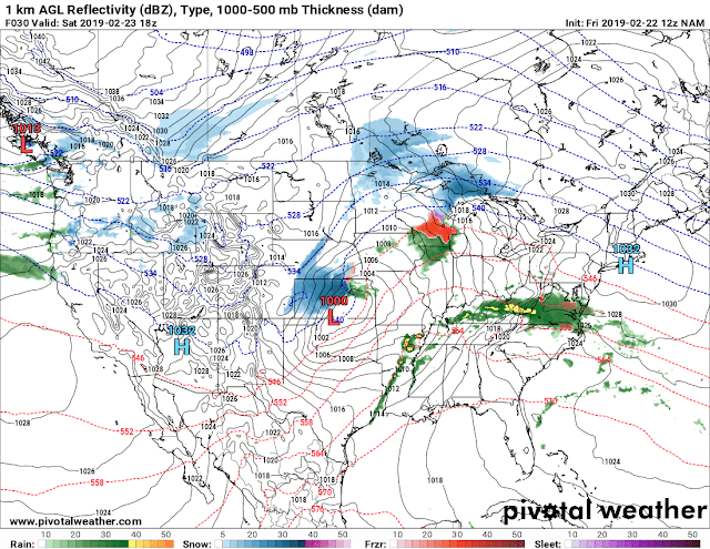
This is the 6am run of the NAM (North American Model), and it shows Thunderstorm development in somewhat of a broken line by Noon on Saturday (tomorrow). With these Storms lies the threat for Hail, Wind, and an Isolated Tornado or two with any storm that can get organized enough. Storm Motion will be Northeast, system motion will be to the East. So they'll develop in the middle of the State, and scoot on out of here pretty quickly.

This is the NAM CAPE Map. "CAPE" is an Acronym, it stands for "Convective Available Potential Energy." CAPE is essentially just the measure of Instability in the Atmosphere. Instability is the key ingredient for Tornadoes, and Severe Weather. As you can see most of the CAPE is over Mississippi, just a little in East Arkansas, that's why this is the area I'm concerned about.

The National Weather Service in North Little Rock, Arkansas has done a great job putting those words into a graph here. All Modes of Severe Weather Possible, but the PRIMARY THREAT here is damaging winds, but with Organization, those Storms within that Line that develop in East Arkansas will be Tornadic, there is an "Enhanced" Risk for Severe Weather issued by Storm Prediction Center in Norman, Oklahoma for East Arkansas where the majority of the CAPE is. Some of these may be Tornado Producers as they move into Mississippi. So, IF YOU LIVE IN EAST ARKANSAS PAY VERY CLOSE ATTENTION TO THIS!!!!
Just a Quick Side note, if you find yourself in the path of these Storms, even if there are no Tornadoes, those strong winds will cause tree damage due to the soft ground and all the rain we've had. So Be Aware of that, and, speaking of rain, if your area is suffering from flooding, and you find yourself in the path of these storms, it will get worse. But these storms will be in and out. IF YOU LIVE IN EAST ARKANSAS SOUTH OF I-40 PLEASE PAY ATTENTION TO THIS!!!!
Follow Me On Social Media
@Omarrian Wilson - Facebook
@OmarrWilson - Twitter
@The Arkansas Weather Hawk - Google Plus
@thearkansas_weatherhawk - Instagram


Comments
Post a Comment