Posts

Showing posts from February, 2022

DEVELOPING: Snow To Storms‼️

Image
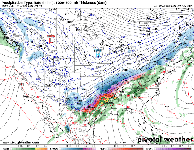
              Hey everybody, how's it going! Last update was about Winter Weather. Now let's talk about a chance for Severe Weather. I have a feeling that pretty soon, we'll be talking about Winter Weather again. Winter, Spring, Winter in the Same Month...... THIS IS HOW YOU ARKANSAS!        Our chance for Severe Weather is Wednesday (Tomorrow), and Thursday. At this point as far as Timing, the weather models are hinting at Overnight Wednesday and into Thursday morning. Thursday morning is looking like the more probable timing for any severe weather we have. There is a possibility for some scattered spinup tornadoes at this point. This is the National Weather Service map for Wednesday Night. The Storm Prediction Center in Norman Oklahoma, has issued a Slight Risk Severe Weather for the West 1/2 of the State. This threat will transition east into Thursday Morning.  This is the Severe Weather Risk into Thursday Morning as the Severe threat transitions into East Arkansas Thurs

DEVELOPING: New Winter Weather Guidance

Image
      GoodMorning Everybody, how's it going! Today is Wednesday February 2nd, 2022. I did a weather update yesterday morning about an incoming High Impact Winter Storm that we have moving into the State of Arkansas. Over the past 24 hours we've gotten new model guidance on this storm and it's possible impacts to the State of Arkansas, and what's expected to setup, and where, and how much. There hasn't been many changes, but there has been a few.       Okay so between yesterday, and today the changes as far as model guidance goes, the European Weather Model has now started to line up with the GFS (Global Forecasting System), and the NAM (North American Model). We're starting to get lot's of model consistency as far as the Models showing the same thing from Run to Run. The NAM is warmer than the GFS, Meaning the NAM is holding off the Below freezing Temperatures until Thursday morning, which if THAT verify, then we wouldn't have as much Freezing Rain as ex

DEVELOPING: 2022 High Impact Winter Storm

Image
      Hey Everybody, how you doing!? Today it is Tuesday, February 1rst, 2022 at 11am in the morning. Since January 28th Weather Forecasters across the country have had their eyes on a Winter storm in the making. Now the Weather Forecast have flip flopped more than the president. But as of Yesterday we're starting to get some model consistency painting a more clear picture of how this stuff will play out, and I must say, it doesn't look good at all.       So of course it was Warm across Arkansas Monday the 31rst, and will be warm through today, and most of tomorrow. With temperatures being that warm, the ground my retain most of that heat, and this will cause the frozen precipitation to not stick on most roadways with the exception of bridges and overpasses. This is my initial thoughts. But this changes after the temperatures drop down to 28° which is what these models are projecting. When the OUTSIDE AIR TEMPERATURES get down that low, everything starts to Ice over, roads, EVE