DEVELOPING: New Winter Weather Guidance
Okay so between yesterday, and today the changes as far as model guidance goes, the European Weather Model has now started to line up with the GFS (Global Forecasting System), and the NAM (North American Model). We're starting to get lot's of model consistency as far as the Models showing the same thing from Run to Run. The NAM is warmer than the GFS, Meaning the NAM is holding off the Below freezing Temperatures until Thursday morning, which if THAT verify, then we wouldn't have as much Freezing Rain as expected by several Tenths maybe. Now the GFS on the other hand has below freezing temperatures setting up way before daybreak on Thursday morning, now if THIS verify then the Ice will start to accumulate way before daybreak on roads, powerlines, and tree which will cause traffic issues, power outages, and tree damage.
Now the Temperatures, with this the temperatures are projected to get as low as 24° on Thursday Afternoon, now if THIS verify then this will cause Serious issues with Freezing Rain and Ice, but the other issue here is power Outages due to the ice. The temperatures will not get any better overnight Thursday and into Friday. As far as Friday goes, I don't see temperatures rebounding much during the day on Friday to allow much melting. Now, on Friday there is a chance for cloud cover which would also prevent melting, so the road conditions will not improve on Friday either. If this happens, we probably won't see much melting until Saturday. Obviously if we can clear the clouds out, and get some sunshine on Friday then the roads will drastically improve.
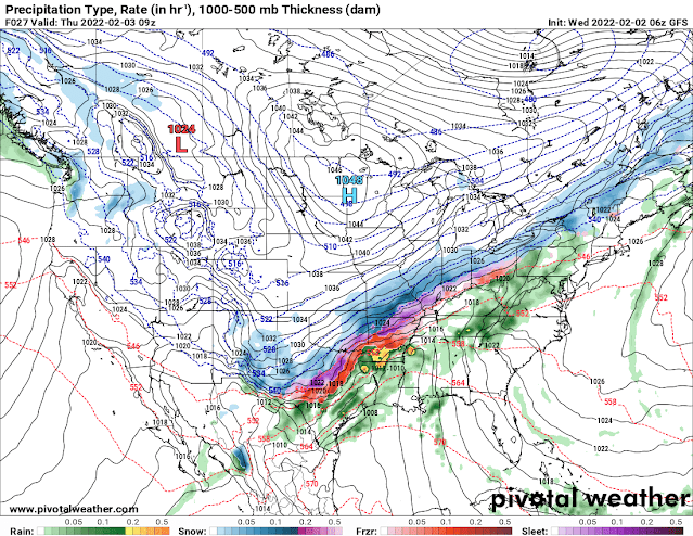
This is the GFS out to the hours of Midnight to 3am Thursday Morning. This shows a large band of Freezing Rain and Sleet drapped across the central 1/2 of Arkansas. I think this will be a mixture of Freezing Rain and Sleet until the temperatures just really nose dive below freezing.

This is the GFS between the Hours of 3am and 6am on Thursday, the GFS really picks up the intensity of the Rain and Sleet Thursday morning. This makes for a VERY messy commute if you must get out.

This is the Temperature map of the GFS out to 6am to 9am Thursday morning. This shows mid 20s in Central Arkansas. The GFS is extremely cold, the NAM isn't this cold, the NAM has 30-31° around this same time frame.
Obviously if the GFS verify, which I really think it might because cold air tends to be a lot more potent then models pick up on. The NAM is undercutting this cold air, I think the GFS has a good handle on it, which isn't particularly a good thing. A Winter Storm Warning has been issued for the Northern 1/2 of Arkansas from Garland County north. I do believe that an Ice Storm Warning will be issued for Arkansas of North Central and Central Arkansas.
Now this Map concerns me, this is via The National Weather Service in North Little Rock, this calls for Areas of Central Arkansas including the Little Rock Metropolitan area to receive a Quarter to a Half inch of Ice. Now remember, anything more than a Quarter of an inch will cause Power Outages, so if I'm in Little Rock, and Points to the North, I'd strongly advise you to take your Winter Weather Precautions, and do whatever you need to do before this stuff moves in.
Thank You for Coming here to The Arkansas Weather Hawk's Blog. Have a GoodMorning, and Stay safe everybody!


Comments
Post a Comment