Posts

Showing posts from March, 2017

**DEVELOPING**SEVERE WEATHER UPDATE: 03/29/2017

Image
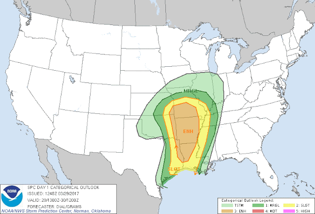
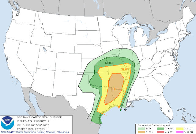
     Hey! How's it going people!!  Look I know everybody is on edge because of our threat for Severe Weather this evening, I get that. Now Let's make something known, NONE of what I do is to create a panic, or scare anybody... This Weather is SCARY!! I know! Nobody Likes Tornadoes, and heavy thunderstorms. But it is LIFE SAVING for you to take these forecast, and weather updates very seriously! Now not much has changed from Last update to this one. Storm Prediction Center updated the risk map a bit, but it looks the same for the most part. This is Courtesy of Storm Prediction Center in Norman, Oklahoma. The Entire State is STILL under a Slight Risk for Severe Weather, and most of the state is Still under an "Enhanced Risk" for Severe Weather. Enhanced Risk means this is the Area, within a general area that I have Heightened concern. COULD A Moderate Risk Be Issued? With the Way the Atmosphere is set up at the moment, I wouldn't be surprised... But IF a Moderat

**SEVERE WEATHER UPDATE: 03/28/2017**

Image
     HEY EVERYBODY!!!! How's it going! Been a minute since my last update, which isn't a good thing to me, because I have a Large "Viewer Base," people rely on me for Weather Information, it's my job to provide it!!!  So I must do better, but Life happens, we don't ask for emergencies. But ANYWAYS, We have a lot to cover, so on to what Matters because THIS, is SERIOUS..........      So there will be TWO rounds of Severe Weather that will strike the State, the First being Tomorrow Afternoon, and Evening, and into the Overnight hours for West, and Central Arkansas. So that's where we'll start. Okay this Map is Courtesy of the Storm Prediction Center In Norman, Oklahoma.... Two different things going on here, first is there's a Slight Risk for Severe Weather for the ENTIRE State of Arkansas. What that means is, there is a Slight Risk for Severe Weather at ANY GIVEN PLACE within this ENTIRE State..... Secondly, there's an "Enhanced Risk&q

SEVERE WEATHER UPDATE: 2017 MARCH WEATHER MADNESS!!

Image
       Hey Everybody! How's it going!! I am Blessed, and busy!!  But I really needed to get this update out there, bc I'm especially concerned about Overnight Storms. Strong storms and Damaging wind is cool during the day and all, bc people can see the storms coming, people are awake, and out&about... But at night, people are at home, relaxing, or SLEEP! And, 90% of people killed in overnight Severe Weather are caught Sleeping, or didn't get the warnings bc they had no NOAA Weather Radio, and their TV's were off.......... I DESPERATELY want to change that by continuing doing what I'm doing. Now with all of that said, lets get on with it!       Now there's a Low Pressure System, with a Frontal boundary associated with it, and due to instability measures, it's looking like there is a threat for Severe Weather present. NOW, with this my MAIN Concern will be that Squall Line (Line of Strong To Severe Thunderstorms associated with a Frontal boundary that mov

*SEVERE&WINTER WEATHER UPDATE* 3/9/2017

Image
      Hey guys how's it going! I hope everybody's having a good night so far. Only in Arkansas do you have a full winter of basically LITTLE to NO Snowfall, then all of a sudden the Storm Season kicks in, get a few Tornadoes, a few Severe Storms, then Winter wants to make a return.... ONLY IN ARKANSAS! Just when we thought Winter was DEAD, Just when we thought it was OVER! Winter will not be denied! More on that later, first thing's first...        Okay, so tonight there is a Slight risk for Severe Weather in the Northeast 1/2 of Arkansas. Then within that Slight Risk, there's an "Enhanced Risk" (More Concentrated Area of Concern.) Now as far as I'm concerned the risk for Tornadoes is VERY LOW! There is Far less Instability in the air then our last two Trouble makers. The MAIN THREATS I'm concerned with at this time is HAIL, and High Damaging Straight Lined Winds. Now there will be a Squall Line that will develop and pose this threat, but instead of m

*+SEVERE WEATHER UPDATE+* Mean Monday Weather

Image
      Hey everybody!  How's it going this morning! Well I said I'd do another Severe Weather Update if I saw in changes in my expectations, or the Weather Maps. And the only changes I really see here regarding our chances for Severe Weather is Timing! All else remains the same. I don't think our chance for Tornadoes is a great as it once appeared to be. They are still Very Possible, but not as likely as it once looked. Let's get into the thick of what the main changes are. Here's a map courtesy of The National Weather Service in North Little Rock, Arkansas. As you can see the Storm Prediction Center definitely shaved back the initial "Enhanced Risk" for severe weather. So it's more focused on West/Northwest Arkansas. Basically what "Enhanced Risk" Means is "A More Focused Area of concern, within a Area of Concern."  As far as Timing Goes, Last Update I said Afternoon, Evening, and night.... Well at this point I'm thinkin

**SEVERE WEATHER UPDATE** #MondayWeatherMadness

Image
     Hey everybody! How's It going! Well our last big weather maker did deliver as advertised, I think we got like 4 tornadoes that day in like two different counties. I must say right now, I GREATLY APPRECIATE EVERYBODY THAT COMES HERE TO THE WEATHER HAWK'S BLOG, And EVERYBODY that follow's me on social Media, and encourages me to keep this stuff going with predicting the weather, and tracking Storms. You guys are AMAZING and I really feel like this work that I do here on the Blog and on Social Media is worth it because people TRUST Me and My Forecast! That's freaking AWESOME! Now with that said, Let's get into Monday March 6th into Tuesday March 7th 2017!       I'm making this update  at 21:51 (9:51pm), Sunday March 5th. There is yet another chance for Severe Weather for Monday (Tomorrow). This System is VERY similar to the system last week. We're looking at a threat for Strong to Severe storms, My Primary concerns will be Hail (LARGE HAIL), Damaging Thun