SEVERE WEATHER UPDATE: 2017 MARCH WEATHER MADNESS!!
Hey Everybody! How's it going!! I am Blessed, and busy!! But I really needed to get this update out there, bc I'm especially concerned about Overnight Storms. Strong storms and Damaging wind is cool during the day and all, bc people can see the storms coming, people are awake, and out&about... But at night, people are at home, relaxing, or SLEEP! And, 90% of people killed in overnight Severe Weather are caught Sleeping, or didn't get the warnings bc they had no NOAA Weather Radio, and their TV's were off.......... I DESPERATELY want to change that by continuing doing what I'm doing. Now with all of that said, lets get on with it!
Now there's a Low Pressure System, with a Frontal boundary associated with it, and due to instability measures, it's looking like there is a threat for Severe Weather present. NOW, with this my MAIN Concern will be that Squall Line (Line of Strong To Severe Thunderstorms associated with a Frontal boundary that moves from West to East.) The main pocket of Instability will be along that Squall Line itself, this is according to the models (GFS, CMC, and NAM) at this current Moment.... This could change a little bit. But with that said, the Tornado threat if any, would be along that Line itself as it moves through the state. Now, if there is a prolonged period of sunshine during the Afternoon daytime, and evening hours on Friday, then any Storms that develop out in advance of that front will have to be closely monitored as well!
As far as Timing is concerned, I'm looking at, the Line developing in East Oklahoma/West Arkansas some time within the hours of 6pm Friday Evening, and 12 Midnight Saturday Morning.... Then Moving across the State from Left to Right throughout the overnight hours.
There is Another chance for Severe Weather LATE Sunday night into Early Monday morning... There is some Instability present, which will lead to the possibility of Severe Storms for at least the Northern 1/2 of Arkansas. Due to the timing of day this is slated to take place, the Tornado Threat is Low.... This is mainly a Wind threat more than anything else, but that is subject to change, we're still several days away at this point. I'll have to watch it develop.

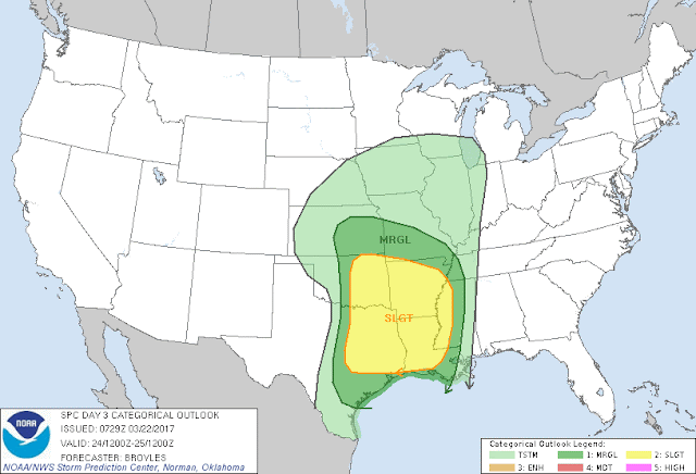
This Map is Courtesy of the Storm Prediction Center in Norman, Oklahoma. In advance of the expected Friday Evening/Saturday Morning Storms, they've issued a Slight risk for Severe Weather. Again, the main threats here is Wind, and Isolated Tornadoes that could Spin up out of that Squall Line. Like I say, any storm that develop out alone, ahead of the front can cause Problems too. We'll just have to watch them. I urge Everybody to Buy a NOAA Weather Radio, they are programmed to your County, and they will sound off if a warning goes out for your County.
If You have Any Questions Feel free to ask me Plz! And, I will do another Update probably tomorrow or Friday as we get closer and things develop more, Thanks for Coming to The Weather Hawk's Blog!
Follow Me On Social Media
@Omarrian Wilson - Facebook
@Omarr Wilson - Twitter
@The Arkansas Weather Hawk - Google Plus


Comments
Post a Comment