**SEVERE WEATHER UPDATE: 03/28/2017**
HEY EVERYBODY!!!! How's it going! Been a minute since my last update, which isn't a good thing to me, because I have a Large "Viewer Base," people rely on me for Weather Information, it's my job to provide it!!! So I must do better, but Life happens, we don't ask for emergencies. But ANYWAYS, We have a lot to cover, so on to what Matters because THIS, is SERIOUS..........
So there will be TWO rounds of Severe Weather that will strike the State, the First being Tomorrow Afternoon, and Evening, and into the Overnight hours for West, and Central Arkansas. So that's where we'll start.

So there will be TWO rounds of Severe Weather that will strike the State, the First being Tomorrow Afternoon, and Evening, and into the Overnight hours for West, and Central Arkansas. So that's where we'll start.

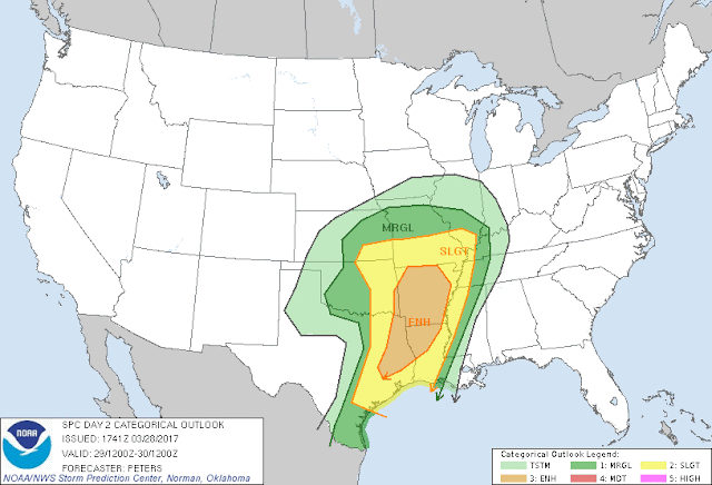
Okay this Map is Courtesy of the Storm Prediction Center In Norman, Oklahoma.... Two different things going on here, first is there's a Slight Risk for Severe Weather for the ENTIRE State of Arkansas. What that means is, there is a Slight Risk for Severe Weather at ANY GIVEN PLACE within this ENTIRE State..... Secondly, there's an "Enhanced Risk" for Severe Weather Within the Slight Risk for a Major area of the State. What that means is, within that Slight Risk area, there's a RAISED Concern for Severe Weather for a Certain area. The Whole State will get good stuff, but the Enhanced Area will ESPECIALLY get it!!

This is the latest run of the GFS, shows instability around South Central Arkansas, in between the Hours of 12noon, and 1500(3pm) ...Any Stroms that can get organized in the areas of Instability MUST be watched for Tornadic Development. The Models disagree on the Intensity of the First Storm System.
This Scenario will likely play out with a Broken Line of Thunderstorms developing in West Oklahoma along a "Dryline," those Storms will intensify as they move into West Arkansas. They will be Severe, and if they can Organized, they WILL pose a Tornado Threat.... That Line will move closer into Central Arkansas as the Eveing turns to Night, threat for Wind, Hail, and Tornadoes STILL PROMINENT. ANY STORMS THAT FORM OUT AHEAD OF THE LINE MUST BE WATCHED FOR TORNADIC DEVELOPMENT. The First Line will Make it's way East throughout the Night!!!
Thursday MORNING, at some point there will be a Redevelopment of another Squall Line that will develop at some point in between Little Rock, and the Mississippi River..... THERE WILL BE A WIND THREAT, HAIL THREAT, AND TORNADO THREAT with that Line as Well!! Kids going to School, and people commuting to Work, or at work, BE WEATHER AWARE! THINGS COULD GET UGLY!!
I FULLY Expect a Tornado Watch at SOME POINT during the day Tomorrow, some people have mentioned different types of Tornado Watches that can go Out... A TORNADO WATCH IS A TORNADO WATCH, THEY ALL MEAN THE SAME!!! BE READY TO RUN AND HIDE! It's simple! It is POSSIBLE, for that Enhanced Risk for Severe Weather to be UPGRADED to Moderate Risk, what that means is there is a SURE CHANCE for Large Deadly Tornadoes, so take UP MOST PRECAUTION!!! You bet your life I'll be on Social Media ALL OVER EVERYTHING that happens! Pull up a Facebook and Twitter tab and Follow my Updates to Stay Safe!!! Thanks for coming to the Blog! Have a Great Night everybody!
Follow Me On Social Media
@Omarrian Wilson - Facebook
@Omarr Wilson - Twitter
@The Arkansas Weather Hawk - Google Plus


Comments
Post a Comment