Posts

Showing posts from February, 2015

The Arkanslushie

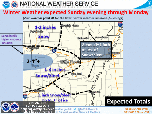
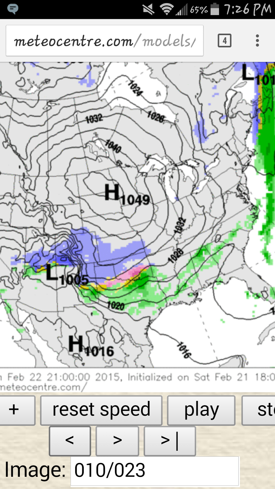
       Guys, after well over a DOZEN School districts close up on Wednesday Morning due to the anticipated Winter Weather moving into the State. The Number 1 Question I'm getting is HOW MUCH, and WHEN? So to answer that question I will say this. This Storm is very entergetic, It has the Moisture, It has the cold air that it wants. So This Storm don't have to ask for much. The only thing that is in question at the moment is WHERE will it go?? This Storm Go even a Mile or two to the North, and Little Rock can score some BIGTIME Snow Totals, This Storm Go a Mile or two to the South, and Little Rock CRASH OUT and Burn on this Storm. This Storm is coming in from South, There is Cold air in place down there, so This is a South Arkansas Storm. But again, if it Jogs to the north a bit, it JUST might increase ur chances for snow. NOW South, and East Arkansas, from Texarkana to Pine Bluff, to West Memphis, These areas and surrounding areas will get the best totals. Hot Springs, Benton, B

Still Some Uncertainty

Image
      Now there's still a certain amount of uncertainty with this next  round of winter weather that is plotted to move in. The uncertainty within the Models and the facts are, What Type of Winter Weather, and where. Timing is pretty much figured out, and amount. So you know me. We will go through this step by step. Okay so what you're looking st here is a map, issued by the National Weather Service. This is what their expecting and how much. Now North Arkansas getting any kind of snow is debatable because this is a Central/South Arkansas Storm. Now There will be a Narrow band of Snow in a Line from Fort Smith, to Little Rock. In that outlined area, I THINK we could see amounts up to 2" of Sleet and Snow, LOCALLY. There could be Isolated Higher amounts in Spots. Areas SOUTH Of Little Rock could see up to an INCH of Ice/Snow Mix.  Now For the Timing, Im thinking LATE This evening maybe around 7-9pm this will start to move in from the west. It Looks like as it's

Early Week SnowMaker

Image
      Okay so This is the Third System that I mentioned in my Last Update. We are now Into the Night on Saturday evening. Now there is Still some uncertainty about this one,  but timing appears to be Late Sunday Evening through Sunday Night. MAYBE into Monday Morning. I have some Weather Models to show you then I'll explain what just Might happen. Okay now this is the NAM Weather Model. It Starts Everything Late in the Night On Sunday. But As we Know, this will Start Earlier in the Evening.  Now According to The NAM it Shows Frozen stuff over spreading the state By Midnight on Monday.  By 3am Monday Morning it shows Freezing rain over Central Arkansas. Now,  In reality that will go south, and that Blue area of Snow will be over Central Arkansas, with Maybe Some areas of Sleet in North Central Arkansas.  Now the NAM shows a Second wave of Moisture moving through with possible Snow LATE Monday Night into Tuesday after the First Wave Sunday Night Into Monday. Will Th

The Arkansas Winter Roller-coaster!

    Okay Jumping right into the swing of things, there is A LOT TO TALK ABOUT. Very DYNAMIC, and bipolar Weather over the next few days. First off we looking at going from Winter Weather, to fall Weather, then from fall Weather to Spring Weather, then Back to Winter Weather.!!!! Put your Seat belt on!!!!       Okay so for Thursday Night into Friday. We are looking at Rain moving later tonight around close to midnight showers will break out.  With Subfreezing temperatures, we talking about freezing rain and sleet. It will be mostly scattered tonight. Tomorrow morning around mid morning is when I'm   expecting it to really pick up. Now to answer everybody's question, YESS This will cause travel issues.  IT WILL STICK. Now During the day Friday temperatures will SLOWLY rise above freezing then that Freezing Rain/Sleet will change over to a plain cold rain.   Now as For Saturday, Im expecting the Temperatures to go into the Mid 60s!!!!!!! Talk about bipolar. Within 24 hours we

Hit and Miss Snow

        Okay, so remember my last post I said their MAY be a few more hit and miss chances this winter for some snow or frozen stuff. Well tomorrow we have one hit and miss chance. Now this will be light and possibly ABSOLUTELY NOTHING. I do NOT think we will get anything for the most part here in Central Arkansas. The ONLY people that might see anything is in Northeast Arkansas around Mt. Home over to Jonesboro or points North of there. They could see a dusting to POSSIBLY a Half an inch, and that's stretching it honestly. This will be NOTHING major. Now don't be Shocked of you see a few flakes flying around the Little Rock area. But this will by NO means be a big deal. It will be VERY cold in the morning. Windchill will be in the Teens around the metro and single digits up north. So DRESS WARMLY.        As Always I appreciate you guys for choosing me to be your go to guy for Weather information. Follow me:  Omarrian Wilson on Facebook @OmarrWilson on Twitter +OmarrWils