Still Some Uncertainty
Now there's still a certain amount of uncertainty with this next round of winter weather that is plotted to move in. The uncertainty within the Models and the facts are, What Type of Winter Weather, and where. Timing is pretty much figured out, and amount. So you know me. We will go through this step by step.
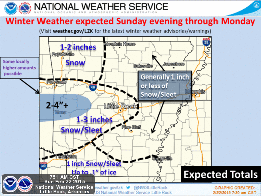
.png)

Okay so what you're looking st here is a map, issued by the National Weather Service. This is what their expecting and how much. Now North Arkansas getting any kind of snow is debatable because this is a Central/South Arkansas Storm. Now There will be a Narrow band of Snow in a Line from Fort Smith, to Little Rock. In that outlined area, I THINK we could see amounts up to 2" of Sleet and Snow, LOCALLY. There could be Isolated Higher amounts in Spots. Areas SOUTH Of Little Rock could see up to an INCH of Ice/Snow Mix.
Now For the Timing, Im thinking LATE This evening maybe around 7-9pm this will start to move in from the west. It Looks like as it's moving it will be mainly SLEET, Then as it gets on in, it will change to Snow. That is for West Arkansas on over to Little Rock, thats how I think this will play out. Now for South and East Arkansas, I think it will come in as Rain/Sleet Mix, maybe some pockets of Freezing RAIN, Then as it get in It will change over to Sleet, and mix with pockets of Snow in some areas. By Midnight-2am Monday Morning This moves into East Arkansas and Gets on out of here. It hits east Arkansas as SLEET.
Area in the Blue is Winter Weather Advisory, areas in the Pink is Winter Storm Warning, Areas in the Purple is Freezing Rain Advisory.
Now Both the NAM (North American Model), and the EURO (European Weather Model), has been hitting on a Second wave of Moisture coming in Sometime on Monday. The NAM has been VERY Consistent with this. The Jury is still out on that one. If It does Verify It will add to our totals.
Now The Ground Temperatures on Monday will be VERY Cold. We will Struggle to get to the MID 20s. So ANYTHING That does Fall tonight and Monday will Be here for a while. This WILL Be enough to Cause issues on the road. Based off of what I see I Do Think Schools in West and Central Arkansas will Close on Monday. Take the day, Go Drifting, Go Mudding, Go Sledding. This will not be a lot, but it will be Enough!!!
As Always I Greatly Appreciate All of You for Coming here to the Weather Hawks Blogg, and choosing me to be your go to guy for Weather information. Y'all be Safe, and Warm!!!
I am The Arkansas Weather Hawk #ARWX


Comments
Post a Comment