Posts

Showing posts from 2020

Christmas 2020 Arkansas Weather Forecast

Image
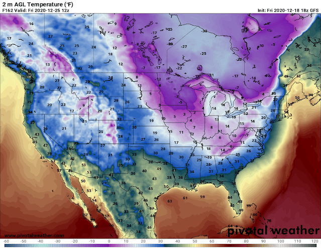
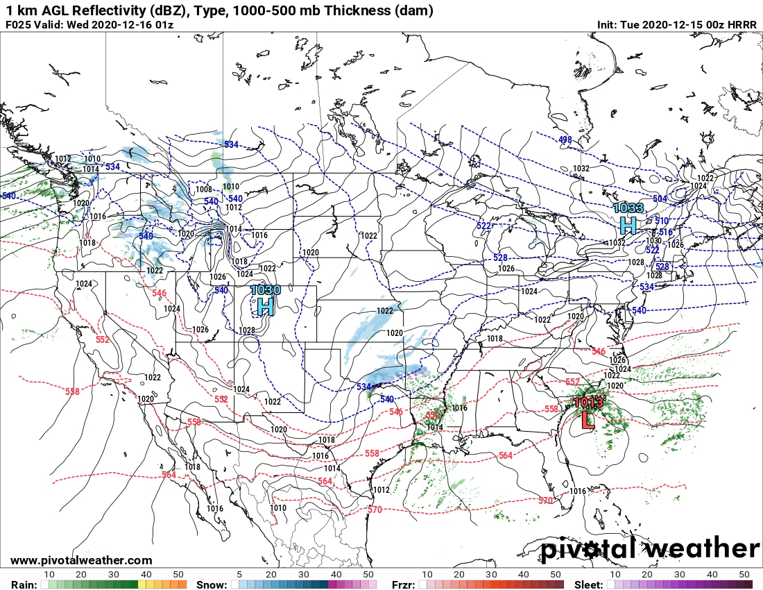
        Hey everybody, I hope Everybody in North, West, North Central, and Northeast Arkansas enjoyed your Snow Days. It's always fun Forecasting Snow Events, because generally everybody loves to see Snow, especially during the Holiday Season, it's cute, and it excites everybody during this time of the year. Even people that don't like Snow have an appreciation for the energy, and Wintertime Vibes it brings during the Holidays. But shifting our focus from Snow, to WHAT?? Christmas Weather!      So on to what is for some, the Best Time of The Year! Christmas 2020 as of right now does look dry, but it looks VERY COLD! Now in the Days before Christmas (Wednesday), there will be a system moving through that will bring some chances for rain with it, so for those people that will be traveling in the days before Christmas, do be aware that there are chances for rain on Wednesday, throughout the day, clearing out of here by Wednesday Night, and Gone by Thursday.  At this time, noth

Developing Winter Weather Update: More Snow!! This Time for Central Arkansas!

Image
        Hey Everybody, How's It Going!? I hope Everybody is safe, and all is going well as we approach Christmas 2020! Like everything else this year, the weather has been on a true roll! I was dead on some updates ago when I released my official Fall Forecast, along with some Winter predictions, because  so far this has been a very busy season for forecasters! From one possibility of Severe Weather, to Several Possibilities for Winter Weather, and so far Two Winter Weather events into the season! Now for the Third? This is the HRRR (High Resolution Rapid Refresh Weather Model), this particular model is a 48 hour model, it tends to be fairly accurate, and dependable in the short range. According to this one Model, the Onset for Winter Precipitation in the state is between the Hours of 3pm and 6pm in the afternoon on Tuesday December 15th. But the Precipitation then starts to drift East into Central Arkansas around 6pm Tuesday Evening.  This is the HRRR Model

Winter Weather Update: Winter Weather Maker Number 2!!!

Image
     Hey Everybody, How's it going!? So Today, and Tonight (December 13th, 2020), we got really good Snow totals out of North, and Northwest Arkansas. I think my last forecast was dead on the money with who was going to get Snow, I didn't want to commit too much to the totals because who, gets how much is a matter of throwing a dart at the wall. But I knew there would be some places in North Arkansas that got accumulating Snowfall to say the least. So far, we have managed to get a mixture of Precipitation here in Central Arkansas with scattered reports of rain/snow mix, but no accumulations will come out of it. So now, WHAT'S NEXT?           Well speaking of the word "Next," there's another chance for some Winter Precipitation in Arkansas on Tuesday Evening, and Night.  Okay so this is the Latest Data Set of the NAM (North American Model), this image is valid between the Hours of 6pm and 9pm Tuesday evening. This model is projecting some Winter Precipitation m

December 2020 Winter Weather Update!!!!

Image
       Hey everybody, how's it going!? I said a couple of Updates back that a shot at some Winter Precipitation before Christmas was possible!!! Here we are today 24 Hours away from a fairly decent chance at some accumulating Winter Weather in the State. Now about 2 weeks ago, we did have a brief mix from Rain-Sleet in Central Arkansas. Certain Higher Elevations in the state switched completely over from rain to snow, but the difference between then, and now is what happened some weeks ago wasn't planned, it was possible but not planned or anticipated, this system is anticipated to bring Wintery Precipitation into Arkansas. So let's not waste any more time, let's get right into this.               So this is the Latest Data Set of the NAM (North American Model), this map is valid between 12Noon and 3pm Sunday Evening, and the model projects a changeover from rain to snow already in Northwest Arkansas. Due to the Onset being so Early in the day, there will be

Developing Winter Weather Update: Polar Vortex is Coming!!

Image
              Hey Everybody! I hope everything is going well with everyone, and I hope everybody had a safe Thanksgiving and Black Friday Holiday! The weather was pleasant on Thanksgiving, was a bit on the cool side Thanksgiving night, I saw some sprinkles in spots around Central Arkansas, but nothing else remarkable, which was good. The Weather Models have flopped a little bit regarding this upcoming Winter Weather situation that I cover in my previous Weather Update.               Now 2 days ago, I made an update sharing my predictions based on the GFS Weather Model. In that update, the GFS noted Freezing Temperatures in Central Arkansas Monday-Thursday of next week. Over the last few Model runs, the GFS and EURO have both warmed up on Wednesday, and both models are consistent on Mid - Low 30s Monday, Tuesday, and Thursday Mornings of next week. At first there were some talks about the Possibility of Some scattered Wintry Precipitation on Monday Morning, but that chance is highly unl

1rst Official Winter Weather Update: ArkanFreeze 2020!!

Image
        Hey everybody, and Happy Thanksgiving! I hope everything is well with everybody, and all is safe! Enjoy your Holidays, and Black Friday shopping. It's officially time for our first Official Winter Weather Update of 2020! I'm sure this year this is Winter Weather Update #1 out of Many this season, and I'm sure most of them will be Temperature related, I don't think we'll have much in the way of Consistent precipitation, but we'll definitely be freezing! Speaking of Freezing Temperatures, that's what this Update is about. Some Weather Models were hitting at a chance for some wintery mix in certain sections of the state in the wee hours Monday Morning, I do not think it's impossible, but I don't think it's likely either.              So about the upcoming chance for freezing temperatures. The temps have already dropped fairly low in certain areas of the state already thus far this season. But here in Central Arkansas, we have yet to reach th

November Arkansas Severe Weather Update: Secondary Severe Weather Season

Image
          How's it Going everybody!? I hope all is well, and everybody is staying safe out there! Here in Arkansas as some of you know, we have Two primary Severe Weather Seasons. We tend to see Severe Weather mors commonly in the transition months when the atmosphere transitions from Cold to Hot, Hot to Cold. The Transition of the atmosphere tends to create a lot of instability with frontal systems that move through, unstable climate conditions create lot's of "Wind Shear" (Turning of the Wind with Height,) thus giving incoming storm systems the leverage to rotate, or produce lot's of Severe Thunderstorm force winds. It's not uncommon here in Arkansas for us to see Tornadoes on Thanksgiving, and Christmas. Halloween is usually cold, and damp, but Thanksgiving and Christmas isn't uncommon to have Tornado Sirens and Lightning around here. So that being said, we are only just a couple of weeks away from Thanksgiving, and here we have today, November 14th, 20

Fall Arkansas Weather Outlook: Like Everything Else in 2020, INCONSISTENT !!!

Image
        GoodMorning, Evening, and Night friends, family, and followers! Thanks' for coming here to the Arkansas Weather Hawk's Blog today! I appreciate everybody's continuing support! In this post I'm going to breakdown my expectations of this Fall leading into this Winter! As if the Year 2020 couldn't get crazy enough with everything else going on in the world, the Weather decided to join the Purge too! Arkansas weather like everything else in 2020, has been on strike, and protesting! We have had 44 Tornadoes so far as of October 2020, our yearly average is 33.... So there's that! We started off the Fall Season with Severe Weather, and will likely finish off the Fall Season with Unusually Dry Weather! Let's break this down!             So about Halloween 2020, I expect this cooler trend in the temperatures to continue. I was looking over previous runs of the GFS (Global Forecasting System), I've been seeing a warming trend in daytime highs during the

DEVELOPING SIGNIFICANT WEATHER UPDATE: Hurricane Gustav 2.0?????

Image
        Hey everybody! How's it Going!? I'm Omarr Wilson, better known as "The Arkansas Weather Hawk" for all the new people tuning in that don't know! I have thousands of New Followers, and I cannot begin to describe to you guys how much the support mean to me! But enough of that, on to this Lady named Laura!! Laura is a brand new Hurricane in the The Gulf Of Mexico that is going NUTS!!!! Typical Woman right 😂😂😂 Laura is taking Dead aim at Arkansas in the next couple of days. ! Laura is bringing some SERIOUS SMOKE to Arkansas, so let's dive into the expectations, and possibilities! No, we're literally about to "DIVE In", in every aspect of the phrase!          Okay, so about Hurricane Laura. What are the Threats? And, where? The Current threats are the whole 9 yards; Wind, Flooding, Severe Weather, Tornadoes, ALL OF THAT! ALL MODES of Severe Weather are 100% Possible with Hurricane Laura, as she makes her way across Arkansas! She's litera

Weather Update 08/06/20: Anymore Rain??? Or No?

      Hey Everybody, I hope all is well, and Everybody is remaining safe, and alive, and well amidst this very irritating time in everybody's lives. I been Getting a Lot of Questions recently about future chances for rain, or anymore relief from the Daytime Arkansauna that we've been having... Well, there's good news, then there's bad news!       Now for the Good News about any type of relief from the "Arkansauna" as I like to call it. At night, over the weekend, the Nighttime lows will be in the Low 70s. I know Low 70s isn't necessarily "Relief" when it's been nearly 100° all day, but anything is better than 100° temperatures right!? And, More Good News for certain areas of the state, there will be scattered hit or miss rain showers in areas of West, South, and North Arkansas. I don't expect much widespread rain or thunderstorm coverage.       Now for the Bad News! Over the Weekend, and next week the Actual Air Temperatures will creep VE

Weather Update 07/29/20: Arkansauna Relief

Image
        Hey Everybody, how's everything going!? I hope well so far! This has been a smoking hot summer, so far I've seen 100° temperatures on Two Separate days in West Little Rock this summer! Not too bad for an Arkansas Summer, but it's been fairly dry this summer except for some brief break in the heat from the Tropics earlier in the Summer. But, now in what seemed like a never ending stretch of baking hot days in July, at the end we get some relief!      Due to a Stalled out Frontal that will hang up over the Arkansas/Missouri Border, we will get scattered Showers, and Storms that will bring us a much needed break in the heat! Between now and August 1rst the National Weather Service expects the Northern 1/2 of the state to receive anywhere between 1-3inches of Rain, some spots more, some less. It's not much, but I'd take some over none! South Arkansas will get something, so don't feel left out if you Live down South. But Central, and the North Half of th

SEVERE WEATHER UPDATE 04/28/2020: 50 Million In Danger‼️

Image
       Hey Everybody, GoodMorning! I hope everybody is continuing to stay safe, and somewhat stress free under the circumstances going on in the country. This Storm season has been VERY active needless to say. Here in Arkansas, today we have yet another significant chance for a major Outbreak of Severe Weather. We've had consistent Severe Weather events every week for the last couple of weeks. This week there is now a Moderate Risk for Severe Weather in parts of Arkansas for today (Tuesday, April 28th, 2020), this evening, and tonight. Let's get into the details.        At First there was a Slight risk for Severe Weather over mostly the West, and Central 1/2 of Arkansas Tuesday evening, and night. The concerns were mainly just hail, and damamging straight lined winds. But the confidence for Torndaoes has increased due to a couple of factors; one being the shear amount of wind energy associated with this system, there's a low pressure system in the Midwest moving due East,

SEVERE WEATHER UPDATE: Easter Issues!!!

Image
       Hey Everybody, I hope everybody is having a happy Saturday afternoon so far! I hope everybody is staying safe in this very inconvenient time in our lives. This weekend will not make things any easier to deal with because today, Saturday April 11th 2K20 we have a chance for Scattered Strong Storms late this evening and tonight. And tomorrow, Easter Sunday April 12th, 2K20, we have a chance for a Widespread Severe Weather Outbreak including Tornadoes. So let's dive off into dynamics, and timing so everybody will understand how serious this situation is.       I'm not so worried about today, I don't expect much in the way of actual widespread Severe Weather today there will be scattered showers, and thunderstorms later today, and there is a chance some of it can be strong to severe, but there's not much confidence of any widespread severe weather. The time-line for today is around 4pm for Southwest, and Central Arkansas to see rain, and thunderstorm development.  

SEVERE WEATHER UPDATE: *MODERATE RISK*

Image
     Hey GoodMorning everybody! I hope You all are enjoying this peaceful Friday morning because Saturday morning will be LOUD, DANGEROUS, AND HECTIC for Meteorologist, and Viewers alike. This is a serious spring setup type system moving into the state today, and tomorrow morning. It's VERY fortunate in some ways that this storm system is moving in when it is, because if this was expected to move through in the evening hours instead of in the middle of the night, we would be talking Tornado Outbreak here. I mean it's bad that this will be an overnight event because this will be when everybody is asleep, and you wont't be able to see what's coming at you which is particular dangerous for motorist. Let Jump into it, in the order of WHAT? WHERE? AND WHEN?       WHAT? ALL MODES Of Severe Weather is Expected Today with these Storms. MAINLY Damaging Straight Lined Winds, Hail, and definitely a chance for Isolated Strong Tornadoes. This Is from the Storm Prediction Center

SEVERE WEATHER UPDATE: Friday Bag of Mixed Weather!

Image
     Hey GoodNight Everybody! I know everybody's been hearing about the developing severe weather situation approaching for Friday night into Saturday morning. Earlier in the week I did a weather update about it, this is just a refresh on the situation, and what I know about it so far from the models. There's a lot to this storm system, from heavy rain chances, to severe weather, to winter weather. This storm system will bring a mixed bag to the state Friday night, and Saturday morning.     First, the heavy rain chances! This Storm System is approaching from the West, but it's drawing in this warm Gulf moisture from the Gulf Of Mexico from a Southwesterly stream. So with this abundance of moisture, heavy rain will be in no short supply! So Flash Flooding will be a definite threat with this storm system over 2 days for the entire state of Arkansas. Marginally this is not a huge Flooding rain event, but that is a lot of rain at one time. So that will create lot's of Flas

Bipolar Arkansas Weather: Watching The GFS

Image
      Happy New Years Everybody!!! The Weather Blog had been on a very long hiatus, but we are   back in the full swing of things! So I've been watching the GFS over the past few days, and the GFS is adamant about wrap around moisture on the back side of this next front coming in changing over as this exists the state. I haven't been buying it too much because the GFS is one of the most inconsistent models outside of that 24 hour window on anything frozen. Now one thing both the GFS and EURO agree on is the possibility for SEVERE WEATHER! Now Severe Weather this early in the year is not unheard of, and it's not uncommon. So there's that.      As far as timing, the rain itself will show up as early as Thursday Morning. Scattered Showers will persist throughout the day Thursday and into Friday. More Scattered Showers Thursday Night. A Second Band of Moisture will setup late Friday Morning into Friday afternoon, the Severe Weather comes into play Friday Evening into Satur