Christmas 2020 Arkansas Weather Forecast
Hey everybody, I hope Everybody in North, West, North Central, and Northeast Arkansas enjoyed your Snow Days. It's always fun Forecasting Snow Events, because generally everybody loves to see Snow, especially during the Holiday Season, it's cute, and it excites everybody during this time of the year. Even people that don't like Snow have an appreciation for the energy, and Wintertime Vibes it brings during the Holidays. But shifting our focus from Snow, to WHAT?? Christmas Weather!
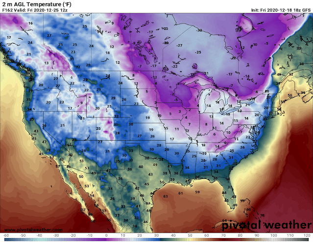
So on to what is for some, the Best Time of The Year! Christmas 2020 as of right now does look dry, but it looks VERY COLD! Now in the Days before Christmas (Wednesday), there will be a system moving through that will bring some chances for rain with it, so for those people that will be traveling in the days before Christmas, do be aware that there are chances for rain on Wednesday, throughout the day, clearing out of here by Wednesday Night, and Gone by Thursday. At this time, nothing prior to Christmas looks to be frozen in nature here in Arkansas. But behind that system moving through the day before Christmas Eve, there will be some very chilly December air setting in. Like bone chilling cold for Christmas! Arkansas Weather might not LOOK like Christmas, but it will definitely FEEL like Christmas with temps in the Low 30s in the Overnight hours on Christmas Morning. On Christmas Day it does look like temps in some scattered areas of Arkansas will not get out of the 30s, then for Christmas Night, the temps will tank back down into the Low 30s! So it'll be cold for sure on Christmas. Below I'll have some pictures of the GFS On Christmas.
This is the Latest Dataset of the GFS (Global Forecasting System) Model. This Image is valid between the hours of Midnight, and 6am Christmas Morning, this model has temps in the Low 30s for Most of Arkansas.
This is the GFS Valid Between the Hours of 6am and 12noon Christmas Day. Now, Weather Models tend to be horrible at forecasting the exact intensity, or movement of cooler air masses, so I would not at all be surprised if the temps do not make it out of the 30s in some areas of the state.
This is the GFS Valid between the hours of 12Noon and 6pm Christmas Evening, and as you can see, the temps are already on the downslope across the state.
Now Keep in Mind that Christmas is still 160 Hours, which is 7 full days away still. So a lot can change with these temperature maps in 7 days. Now there are Two Chances for rain between Today (12/18/2020), and Christmas Day. There's One Chance on Saturday 12/19/2020, and Wednesday 12/23/2020. I don't see a chance for Winter Weather, or Severe Weather on Either Day. If there's any substantial changes in anything I will bring everybody up to date!
Follow Me for Updates on Facebook
@Omarrian Wilson
@Arkansas Storm Spotters
@Arkansas Weather Community
@Arkansas Storm Report Group
Subscribe To The Blog for Email Updates!


Comments
Post a Comment