SEVERE WEATHER UPDATE: *MODERATE RISK*
Hey GoodMorning everybody! I hope You all are enjoying this peaceful Friday morning because Saturday morning will be LOUD, DANGEROUS, AND HECTIC for Meteorologist, and Viewers alike. This is a serious spring setup type system moving into the state today, and tomorrow morning. It's VERY fortunate in some ways that this storm system is moving in when it is, because if this was expected to move through in the evening hours instead of in the middle of the night, we would be talking Tornado Outbreak here. I mean it's bad that this will be an overnight event because this will be when everybody is asleep, and you wont't be able to see what's coming at you which is particular dangerous for motorist. Let Jump into it, in the order of WHAT? WHERE? AND WHEN?
WHAT? ALL MODES Of Severe Weather is Expected Today with these Storms. MAINLY Damaging Straight Lined Winds, Hail, and definitely a chance for Isolated Strong Tornadoes.


WHAT? ALL MODES Of Severe Weather is Expected Today with these Storms. MAINLY Damaging Straight Lined Winds, Hail, and definitely a chance for Isolated Strong Tornadoes.

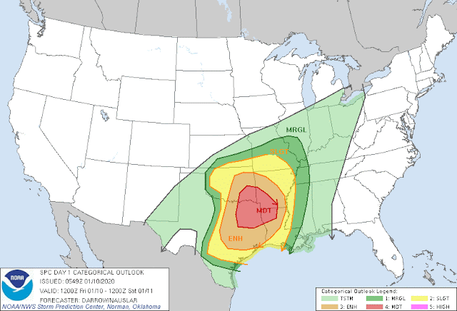
This Is from the Storm Prediction Center in Norman Oklahoma. There is a Slight Risk for the Entire State pointing out that there is a risk for some type of Severe Weather everywhere. There is an "Enhanced Risk" for Severe Weather in the South&West 1/2 of Arkansas, which means that this is an area of heightened concern that this area could see worse weather than anywhere else. There is now a "Moderate Risk" for Severe Weather in Southwest Arkansas. This is their way of saying "There Will Be Severe Weather, and Tornadoes in This Area, and Some of them Will Be Strong!" FLOODING, WIND, HAIL, TORNADOES Is All Possible Everywhere, but especially in the Emphasized Areas.
WHERE? Well If it isn't clear enough by this point what's expected, and where, let me break it down! In the West and South 1/2 of Arkansas is where the most CAPE (Measure Of Instability within the Atmosphere) is setup according to the Weather Models.The Entire State has risk, sure! But Southwest, and Western Arkansas need to be on high alert because this system will move in as a Squall Line of Thunderstorms, and the measures of Lift, Windshear, and Instability aloft will be particularly High in those areas, so people in those areas need to pay extra close attention to what's around them, because this will be at night when you can't see what's coming.

This the NAM (North American Model) showing building Instability from the Southwest between the Hours of 9pm and Midnight Tonight! This is why that Moderate Risk for Southwest Arkansas is in place.

This is the HRRR (High Resolution Rapid Refresh) Model out to 7pm Tonight showing Building Storms out ahead of the Squall Line in Southwest Arkansas. These Storms will be developing in an Unstable Area, and I'm VERY positive that there Will be Tornado Watches all Over this area, and maybe a few warnings.

This is The Significant Tornado Parameter of The NAM. This map shows where the chance for Significant Tornadoes (EF-3 Or Higher) is. You See THIS is what Concerns me, its from Southwest All the Way into Central Arkansas, Up the Interstate 30 Corridor between the hours of 9pm and 12am Midnight tonight. This is the area of the Moderate Risk, and there will DEFINITELY be a Tornado Watch of Some type in this area.
WHEN? As for timing. There will be scattered Showers throughout the day today. But Storm initiation looks to be late evening into overnight. Scattered Strong to Severe Storms will develop in Southwest Arkansas in between 6pm and 9pm Tonight. The Squall line will start to move through West Arkansas in between 9pm and Midnight Tonight. Central Arkansas In between Midnight and 3am in the Morning, and East Arkansas in between 3am and 6am Tomorrow Morning. It could be worse because this is moving in overnight and not in the early evening. If this was moving in around 3-5pm this evening, it would easily be an Outbreak. OVERNIGHT STORMS ARE THE DEADLIEST IN ARKANSAS. You Cannot See them if you're driving, and people are usually asleep. KEEP A NOAA WEATHER RADIO NEAR BY!!!! Keep Phones On, and Charged, And crank that Volume up on the News Channels to get alerts!


Comments
Post a Comment