SEVERE WEATHER UPDATE: Friday Bag of Mixed Weather!
Hey GoodNight Everybody! I know everybody's been hearing about the developing severe weather situation approaching for Friday night into Saturday morning. Earlier in the week I did a weather update about it, this is just a refresh on the situation, and what I know about it so far from the models. There's a lot to this storm system, from heavy rain chances, to severe weather, to winter weather. This storm system will bring a mixed bag to the state Friday night, and Saturday morning.
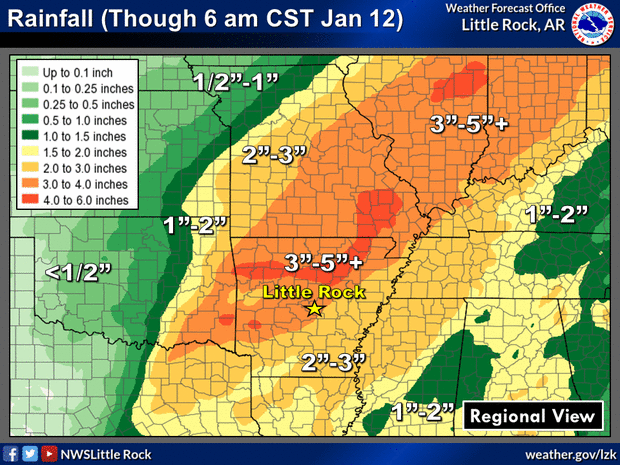
First, the heavy rain chances! This Storm System is approaching from the West, but it's drawing in this warm Gulf moisture from the Gulf Of Mexico from a Southwesterly stream. So with this abundance of moisture, heavy rain will be in no short supply! So Flash Flooding will be a definite threat with this storm system over 2 days for the entire state of Arkansas. Marginally this is not a huge Flooding rain event, but that is a lot of rain at one time. So that will create lot's of Flash flooding.

First, the heavy rain chances! This Storm System is approaching from the West, but it's drawing in this warm Gulf moisture from the Gulf Of Mexico from a Southwesterly stream. So with this abundance of moisture, heavy rain will be in no short supply! So Flash Flooding will be a definite threat with this storm system over 2 days for the entire state of Arkansas. Marginally this is not a huge Flooding rain event, but that is a lot of rain at one time. So that will create lot's of Flash flooding.

This is from The National Weather Service in North Little Rock. In certain areas of the state as much as 5" of rain is expected across a vast area of North Central, and North Arkansas. 1 - 3" expected elsewhere. Generally compared to our totals for the year, and over the past month, that's not an awful lot. But 5" of rain at one time is definitely a Flash Flooding Concern.
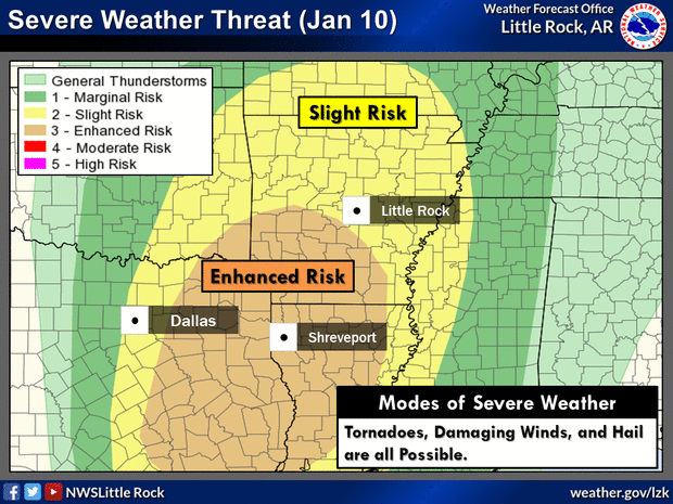
Now on to the Severe Weather. This storm system will produce a lot of of very strong wind energy, so that being said Damaging Straight Lined Thunderstorm Winds are at the upmost concern with this. Lot's of times Thunderstorm Winds are worse than Tornadoes themselves! These storms will be in the form of a Line of thunderstorms (Squall Line), and will move from Left to Right across the state. Timing with this is Friday Evening up to Midnight Saturday Morning for West Arkansas, and between 12am Midnight at 3am Saturday morning for Central Arkansas, then between 3am and 6am Saturday morning for East Arkansas. Now Wind, Hail, and Tornadoes will be a threat for all sections of the state at this point.

This is from The National Weather Service in North Little Rock. Slight Risk for Severe Weather for the entire state, Enhanced Risk for Severe Weather in the Southwest section of the state just because that's the area where instability is highest at this point. "Enhanced Risk" means an area of higher concern than anywhere else basically. ALL MODES of Severe Weather are possible Everywhere In the State. IF THERE IS ANY TORNADOES IT WILL BE ALONG THE SQUALL LINE ITSELF! With this setup, there isn't any widespread Instability available for tornadoes, so if there are any, they will be SPIN UP Tornadoes within the Kinks of the Squall Line itself. So that Line will be heavily watched as it moves through the state. Tornado Watches will be issued as needed along and ahead of the Line.
There is a Chance for Winter Weather on the backside of the Storm System for West and Northwest Arkansas. ALL ACCUMULATIONS WILL BE LIGHT! I do Not expect widespread Snowfall in the state, and I don't expect it to be especially heavy!. If there are any bands of snow to setup, they will be narrow, and it will be very light. However, certain areas of North, and West Arkansas may see a dusting depending on the thickness of the Snow bands that setup.

This is the GFS Forecast Model, out to Noon on Saturday Afternoon, it's showing the presence of wrap around moisture around the backside of the storm system as it moves out. I'm not exactly sold on this if I'm being honest here, but this model has been very consistent with this over the past several days, so it's definitely in the realm of possibilities. Like I say, accumulations will be light, and isolated.
On Friday Evening, Night, and Saturday Morning, KEEP THOSE WEATHER RADIO'S HANDY! Spin Up Tornadoes form quickly and randomly, if one spin up over your town or house you will not have much time to get to cover. So Keep those Weather Radio's Charged, On, and Handy, they will wake you up out of your sleep. In you are sleep in the night, you will not hear Tornado Sirens, or a phone, Keep those radio's on. If You don't have one, keep that phone ringer on, and that TV volume up! Nighttime Tornadoes are the Deadliest ones here in Arkansas!


Comments
Post a Comment