SEVERE WEATHER UPDATE:❗ Mid-Week Trouble !❗❗
Good Morning everybody, how's it going?! I hope everybody is having a safe, and Fantastic day so far. It is that time of year. Severe Weather Setup, after Severe Weather Setup, they are rolling in like Clockwork now. So following Saturday's Storms, which came as expected; with Isolated tornadoes, and strong to severe wind. No fatalities, no injuries, everybody heeded the warnings very well. There was some misconceptions about the matter of Tornado Sirens, and how they work, I'll make a separate post about that. But as far as today (Wednesday March 13th is Concerned).
There is a system making it's way from the West, it should be here inbetween now, and this afternoon With it comes the Wind Energy that's needed for Severe Weather, combine that with moisture coming up from the South, and we have a mixture of Instability on our hands which means Severe Weather. So as far as I see right now the primary focus will be on the southern part of the State. The main threat with this is wind, but the chance for Isolated tornadoes is ALWAYS there with storms that get out ahead of the main line of Storms, off to themselves, they can get organized and pose a threat. The greatest threat here is for East Arkansas, there is a Slight Risk for Central Arkansas, but an elevated (Enhanced) risk for East Arkansas.


There is a system making it's way from the West, it should be here inbetween now, and this afternoon With it comes the Wind Energy that's needed for Severe Weather, combine that with moisture coming up from the South, and we have a mixture of Instability on our hands which means Severe Weather. So as far as I see right now the primary focus will be on the southern part of the State. The main threat with this is wind, but the chance for Isolated tornadoes is ALWAYS there with storms that get out ahead of the main line of Storms, off to themselves, they can get organized and pose a threat. The greatest threat here is for East Arkansas, there is a Slight Risk for Central Arkansas, but an elevated (Enhanced) risk for East Arkansas.

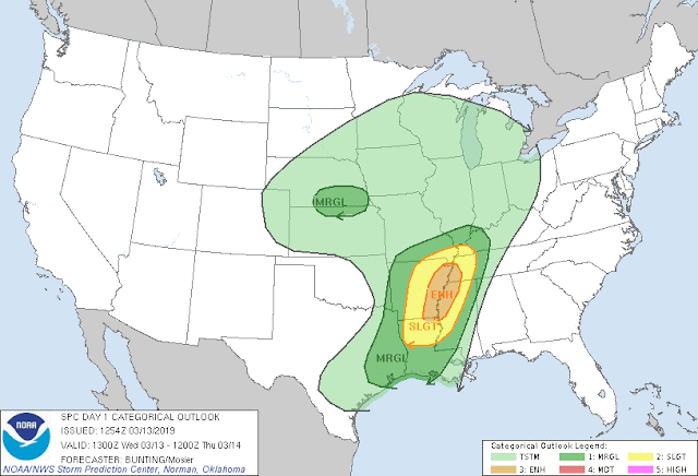
This is the Risk Map Courtesy of the Storm Prediction Center in Norman Oklahoma. As you can see, elevated Enhanced Risk over East Arkansas, slight risk for everywhere else.

This is the 6am Run of the NAM (North American Model), it shows around 3pm this eveneve a line of Thunderstorms moving from West to the East Across the State. If there are any Tornado Warnings with the line itself, it would be within the Embedded "Kinks" within that line. Otherwise this will pose a threat for Damaging Straight Lined Wind.

This is the NAM out to 6pm or inbetween the hours of 3 - 6pm that line of Storms will be in East Arkansas by that time. This is the area of the State that will have the highest concern for Tornadoes, so once these storms get out there they will have to be monitored very closely.

This is the 6am run of the HRRR (High Resolution Rapid Refresh) Model. This is the "CAPE" (Convective Available Potential Energy) map, it's essentially the measure of Instability in the Atmosphere, which is the key ingredient for Tornadoes. The Instability is highest over East Arkansas, from Little Rock on East. This is why there's an Enhanced Risk over that area, and this is why our greatest concern is that area.
A Tornado Watch will be issued at Some Point for East Arkansas. From Little Rock on East most likely. Tune to my Social Media for further Updates. Thanks for coming to the Weather Hawk's Blog.
Follow Me On Social Media
@Omarrian Wilson - Facebook
@OmarrWilson - Twitter
@thearkansas_weatherhawk - Instagram


Comments
Post a Comment