‼SEVERE WEATHER UPDATE 5/17/19: A SEVERE SATURDAY ‼
Hey Everybody, how's it going!? I hope everybody is having a fantastic day so far because tomorrow will be not soo good for those that aren't having a good day today! So get your partying in because the weather will definitely put a damper on your day tomorrow no doubt!
So there is a Chance for a Severe Saturday shaping up for the state tomorrow. The threats for Hail, and High Water, and Winds are greater than the chance for Tornadoes. But however, there is a pretty substantial threat for Tornadoes tomorrow for West, and parts of Central Arkansas.
As far as Timing, the HRRR (High Resolution Rapid Refresh) Model shows everything coming through by tomorrow evening, and night. Tomorrow evening for West Arkansas, that timeframe set's a dangerous situation for West Arkansas, because that's the time of day, around 6pm when the heat of the ground is at it's peak. Tornadoes love that time of day for just that reason. As it get's later in the evening 8-10pm, Central Arkansas will be under the gun of this Squall Line. 3-7pm CDT for West, 7-10pm for Central, the further East this will weaken, and the threat for dangerous weather will be lessened.

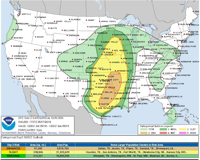
This is a Risk Map, Courtesy of the Storm Prediction Center in Norman Oklahoma. They have issued an Enhanced Risk for Severe Weather for West Arkansas, which means that there is an increased cause for concern for that particular area of the State. Everywhere could see Severe Weather, but ESPECIALLY that Enhanced Risk area.

This map is Courtesy of the National Weather Service in North Little Rock, Arkansas. This map is really good at detailing what the specific threats are, and how much certainty there is for those threats. There is a Chance for tornadoes, and tornadoes are expected. But there isn't as much of a Chance for Tornadoes then there is Wind, and Hail.
If anything threatens the Central Arkansas area, I will activate, and pursue the Storm, or Possible Tornado. But I will be Tracking ALL of this as it moves through until it clears the viewing area. This will setup as a Sqaull Line, but in Line Situations, there is a chance for Spinups along the Line itself. There's also Tornado Threats with Storms out ahead of the Main Line and Off to themselves. I will be Monitoring EVERYTHING, So follow me on Social Media.
Follow Me On Social Media
@Omarrian Wilson - Facebook
@OmarrWilson - Twitter
@thearkansas_weatherhawk - Instagram


Comments
Post a Comment