Fairly Active, And Cold Weather Pattern To Come
Hey everybody, How's it going! I just want to say I hit a huge spike in viewers here on the Weather Hawk's Blog on my Weather Update from Yesterday. I SERIOUSLY Appreciate everybody for coming here to the Weather Hawk's blog for Weather Information. Now Let's get into our active Weather Pattern Shall we!?
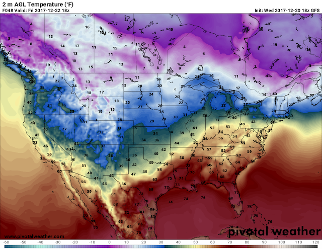
First thing's first, I've been Looking at the GFS (Global Forecasting System) weather model, and it's very cold on Wednesday Night, and into Thursday of This week. Possibly Freezing-Subfreezing Temperatures in West, and even into parts of Central Arkansas. The NAM (North American Model) is ALSO showing the EXACT same thing! Now the Timing on the air according to the Models is Late Evening on Wednesday.... Here's my deal with that, WEATHER MODELS ARE NOT GOOD WITH COLD AIR! Cold Air is Heavier and more dense, so it falls towards the equator quicker than our Computer Models can calculate! I'd bet my Bottom Dollar that IF THIS VERIFY, it would be Very Cold Wednesday Night. THE TIME HAS COME, We're Making the Transition!!!! Unfortunately, NO MOISTURE WILL BE IN THE AIR ANYWHERE, No chance of Frozen stuff!
Now that brings me to Our next chance for Rain.... Our next chance for rain isn't until Saturday, Into Sunday. There's another chance for rain Next Tuesday, followed by another chance for rain next Thursday.... Even Saturday is a long way out, but from this far out all 3 chances for rain look to be. substantial.
As always I really appreciate everybody for coming to the Arkansas Weather Hawk's Blog, enjoy the rest of your night, STAY SAFE!
Follow Me On Social Media
Omarrian Wilson -Facebook
@OmarrWilson -Twitter
The Arkansas Weather Hawk -GooglePlus


Comments
Post a Comment