WET WEATHER WEEK AHEAD!!
GoodMorning Everybody, I hope everybody had a safe night! I was planning on doing a weather update last night, but work wouldn't give me the time of day. I'm finally off! Anyways, on to the weather, there is A LOT to cover!
Okay First thing's first, this weekend will be awesome! Today, and tomorrow will be great. Get out, wash the car, wax it, go for a little cruise in your nice clean ride. Get out enjoy the weather, IT WON'T LAST LONG......
*Next Week, Okay so You know I study 3 Weather Models, NAM (North American Model), GFS ( Global Forecasting System), CMC (Canadian Weather Model). Now I look at and observe other weather maps, but my big 3 is those 3. Now all of the models agree on the Onset of this next BIG TIME weather maker.......TUESDAY. The Rain will start sometime during the morning hours on Tuesday. Overnight Tuesday, and into Wednesday there will be a frontal boundary setup and it will stall, and just sit over Arkansas. Wednesday morning a line of storms will develop and move right to left across the state. NOW, with that line comes a chance for Severe Weather!!!
* Severe Weather, with that first initial Line on Wednesday Morning comes our greatest threat for Severe Weather. And, even then, I'm only saying gusty winds, heavy Rain, maybe some hail. LIGHTNING as well. No Tornadoes, I don't expect any tornadoes mainly due to the time of day. Morning time, no instability, no ground heating, no tornadoes. Just Wind, Rain, and hail. Don't forget the Lightning.
*THE MAIN STORY, FLOODING!!!! Now here's the main headline with this weather maker. When this front moves in on Wednesday morning, it will stall. What that will do is allow MULTIPLE waves of moisture to "train" through Arkansas (Back to Back, One after Another). Onset being Tuesday in West Arkansas, Line moves through overnight Tuesday and into Wednesday. After that, I'm talking about NOTHING but Band after Band of moderate to heavy rainfall moving through the entire state as those disturbances move through the state. Wave after wave of moderate to light to heavy and back to moderate rainfall.
How Long will this Last, Well with the Onset to everything being Tuesday, the Weather Models don't show the rain coming to an end until Saturday as that last disturbance pass by. That's 4 STRAIGHT CONSECUTIVE DAYS of Moderate to Heavy Rainfall!!!! As far as Rainfall totals! AW MAN, We're looking at 5-8inches AT BEST of Rainfall, Maybe Isolated Higher Amounts! HEAVY FLOODS AGAIN!!! See Pictures Below!

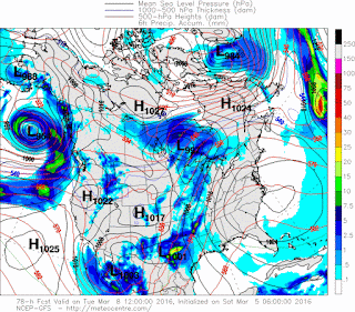
This first Picture here is the GFS Weather Model, as you can see it shows the onset of the moisture that's being pulled up from the Golf Of Mexico by that first disturbance which is Located in Texas. This is by 12noon Tuesday. Onset is Across the Western portions of the state.

This map here is Courtesy of the National Weather Service in North Little Rock. The brightest highlighted area is where the heaviest rainfall is expected, thus that area stands the GREATEST Flooding area of concern. Large area of the state. Don't take this literally, this map could be "Fine Tuned" over the days to come.

This is the GFS for Wednesday morning, if there is a threat for any severe weather, it will be from this little line of storms here that will likely be a broken line. Now the greatest threats with this will be heavy rain of course, gusty winds, and MAYBE some embedded Hail... Thats it.

This is the GFS Thursday evening, Two bands of moderate to heavy rain setup to move through after a full Wednesday, and Thursday of rain.... This is a chance for some Heavy rain man. Good Flooding chances.

This is the CMC Canadian Model, I think it shows the end of this more realistically. The Canadian is overnight Saturday getting this rain done with Arkansas. The GFS is Monday getting it out. I do not think it will even take as long as Saturday Night to be honest. But this map here is valid overnight Saturday, and into Sunday.

This is another map courtesy of The National Weather Service showing basically why all the rain, and giving some preliminary rainfall accumulations. PRELIMINARY! But they are basically right in line with what I expect, 5-8inches of rainfall across a huge portion of Arkansas with Locally higher amounts.
I want to Thank You for Visiting The Arkansas Weather Hawk's Blog, if you made it down this far. I know It's Long, I'm sorry, but you all need to know this stuff. LIKE, SHARE, COMMENT! I LOVE FEEDBACK! Hit me with any Questions you may have.
Follow Me On Social Media
TheArkansas WeatherHawk - Facebook
@OmarrWilson - Twitter
The Arkansas Weather Hawk - Google Plus


Comments
Post a Comment