*Monday Severe Weather Update*
GoodMorning everybody, how's it going! Just figured I'd do another update to keep you guys informed, the only thing that has changed is the risk area by the Storm Prediction Center in Norman Oklahoma. The way this will play out according to the Model data, storms will start to fire in West Arkansas, then into South Central Arkansas. Should Storms start to fire and get organized in this risk area, there will be Tornado Warnings with some, if not a lot of these storms. Now we have some rain about to move through, Im looking at the possibility of what we call "Evaporative Cooling" which in this process, the rain cooled air stabilizes the atmosphere limiting the formation, and organization of thunderstorms. That's something I'm looking at. But right now it's precips around, I'm looking for this stuff to blow off, and this evening for that system to move closer to Arkansas, and storms still start to fire out west. In sequential order they'll start to fire out here in Central Arkansas late in the evening. When these storms initially start to fire, then is when the chance for Tornados will be. Now the more these storms fire tonight the chance will change from a tornado threat to more of a wind threat as they jell into a line and move into East Arkansas. See pictures below.
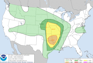


Here's the actual risk area as issued by the Storm Prediction Center in Norman Oklahoma. "Enhanced Risk" for Southwest, West, and Central Arkansas. Slight Risk everywhere else. "Enhanced" Risk means a raised area of concern within a general area of concern. So there's a Slight risk for the state, that orange Enhanced Area is a greater area of concern within that slight risk. As to say, the state itself has a threat for bad weather, but THIS area ESPECIALLY have a threat. That's the Breakdown of "Enhanced Risk".

Here's a better breakdown of the risk areas by The National Weather Service in North Little Rock. You see that Enhanced Area is for West, Southwest, and Central Arkansas. The Main threats with this will be Wind and Hail, but Tornadoes are a threat If anything can get Organized!
As I said, I'll say again, the MAIN THREATS ARE WIND, AND HAIL, but TORNADOES are a possibility IF storms can get ORGANIZED! If a storm get's organized, it will LIKELY go Tornado Warning, so BEWARE!!! Anybody in West, Southwest, or Central Arkansas within that orange shaded area has a chance to see all 3 forms of Severe Weather! I FULLY expect a Tornado WATCH at Some point this afternoon for West, and areas of Central Arkansas! Just a little disclaimer, these storms will be in a moist environment with a lot of hail, so Lightning will be a reality... I'll be here tracking this weather ALL DAY! Let me know if you have any Questions.
Follow Me On Social Media
Omarrian R Wilson - Facebook
@OmarrWilson - Twitter
The Arkansas Weather Hawk - Google Plus


Comments
Post a Comment