Tropical Arkansas!?!?!?!
GoodMorning Everybody! I know you're probably wondering what's up with my Title Lol. Well, I have something to share with you guys. Okay, so you remember last Post, I touched on the subject of the Atlantic Basin Hurricane Season activity picking up right.? Well turns out that I was actually right! It was more of a "Hunch" Comment if you will, that I made. I didn't want to say it because I was unsure about that feeling regarding the Hurricane Season because it's been soo long since we've had to discuss Hurricanes here in Arkansas. But there is a System developing in the Atlantics that is catching my attention...... ⇩↓▼
The last memorable Hurricane that even had a memorable impact on Arkansas was Hurricane Gustav in August of 2008. That was the last Major Tropical System that had a significant impact on Life here in Arkansas. NOW, WITH THAT SAID! I DO NOT THINK, this System will even be remotely close to that dramatic, especially for these parts. But depending on the track of it, it could effect our weather here in The Natural State. That's a BIG IF might I add.
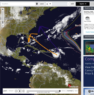
There are 3 basic trajectories that I could come up with from all the different tracks of the Weather Models of where this thing could go, See Below!
The Blue Path is the Least Likely, Followed by the Gray Path, with the Orange Path being the most Likely or Similar to it. Now what does this mean for us? Well, what I see here is if the Gray path was to verify (Saying that the dogon thing even holds together or intensify from it's current state), if it was to take that particular track, then it could give us (Depending on the Exact Trajectory) a chance for either Severe Weather (Including Tornadoes), or a Chance for a Multi-Day Constant Rain event. That all depends on it's exact Trajectory along that particular track. If the Orange path verify, (and the Storm Intensify to Tropical Storm, or God Forbid, HURRICANE Status) then that spells Bad News for Florida, Georgia, and the other Eastern States. It just means, a change in our weather pattern in some type of random way.
I'm in NO WAY telling you guys that I directly believe this will effect us, I just figured I'd share my preliminary thoughts on what the Possibilities are with this System. It's been a long time since we've had to deal with Hurricanes, and Tropical Storms n such over in these parts. Mainly due to Windshear, and the Lack of Atmospheric support for Hurricanes to develop. Hurricanes and tropical systems are very touchy, and dynamic systems, everything has to be PERFECT for one to get going, let alone grow. Those opportunities are a dime a dozen these days. I'll keep you guys posted!
Thanx for Coming here to the Weather Hawk's Blog, I enjoy doing this, and your support means the world! Have a Great Wednesday Everybody!
Follow Me On Social Media
@Omarrian Wilson - Facebook
@OmarrWilson - Twitter
@The Arkansas Weather Hawk - Google Plus


Comments
Post a Comment