**SEVERE WEATHER UPDATE** Severe Weather Saturday
Hey GoodMorning Everybody! I hope everybody had a safe day yesterday, there was well over two dozen accident reports across Central Arkansas. I hope everybody that follows my weather, and visits the blog took my advice and drove safely. Yesterday did exactly what I said it would do by just adding on to our rain totals making them way worse in areas that do NOT need anymore rain. Today (Saturday, February 24th) will be no different, only exception with today is the fact that we will have Severe Weather, and Tornadoes to deal with!
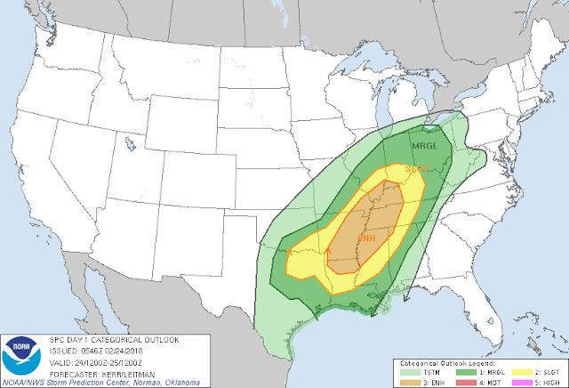
Now how bad is it going to get? And where?..... Well just like I stated yesterday, we will have a front that will move through today and put an end to the deluge of rain we've been getting. But with that front will come the chance for Severe Weather due to the increase in warm moist air that will meet with this front over Arkansas. The warm air will be most abundant and unstable on the EAST side of the I30 Corridor, so from Little Rock to points on South and East will have the highest concern for tornadoes to develop. Now with that said, the Storm Prediction Center in Norman Oklahoma has issued an "Enhanced Risk" for Severe Weather in Central and Southeast Arkansas, see pic below:

Now how bad is it going to get? And where?..... Well just like I stated yesterday, we will have a front that will move through today and put an end to the deluge of rain we've been getting. But with that front will come the chance for Severe Weather due to the increase in warm moist air that will meet with this front over Arkansas. The warm air will be most abundant and unstable on the EAST side of the I30 Corridor, so from Little Rock to points on South and East will have the highest concern for tornadoes to develop. Now with that said, the Storm Prediction Center in Norman Oklahoma has issued an "Enhanced Risk" for Severe Weather in Central and Southeast Arkansas, see pic below:

This is Courtesy of the Storm Prediction Center in Norman Oklahoma, they have issued an "Enhanced Risk" for Severe Weather. Enhanced Risk means there is a greater more elevated risk of Severe Weather within a specific area. The entire state is under a risk for bad weather, but ESPECIALLY the area outlined in the Enhanced Risk.

As far as what to expect, as I said in yesterday's update, the main threats expected is high damaging thunderstorm winds, and isolated Tornadoes with any storms that are able to get organized.
What time is all of this supposed to start? Well according to the latest runs of the HRRR (High Resolution Rapid Refresh), and NAM (North American Model) weather models, there will be scattered showers around in the morning, they will move off to the north. The front will start to move into West Arkansas from out of Oklahoma, and a Squall Line (Line of Strong To Severe Thunderstorms along along the leading edge of frontal boundaries), will start to develop along the front as it moves into Arkansas. By about 1pm the Line will start to work it's way out of West Arkansas into parts of West Central and Central Arkansas at that point there will LIKELY be numerous Severe Thunderstorm Warnings and possible Tornado Warnings associated with "Kinks"(Areas of "Spin up" rotation that develop along the leading edges of Squall Lines), that may develop. I expect this line of Severe storms to make it into Central Arkansas or close at around 3-4pm this afternoon. It's into East Arkansas by 5-6pm and out of here by 9pm tonight So as you can see this system will be fairly quick moving. I DO FULLY EXPECT A TORNADO WATCH TO BE ISSUED THIS AFTERNOON FOR CENTRAL AND SOUTHEAST PARTS OF THE STATE!!
If a Tornado Watch gets issued, I will start to continuously scan the radar for any storms that try to get organized, if any Tornado Warnings get issued I will do Minute by Minute Weather Updates on Social Media, so be sure to FOLLOW ME ON SOCIAL MEDIA ! Thanks for coming to the Weather Hawk's Blog, have a Great Morning Everybody!
Follow Me On Social Media
@Omarrian Wilson - Facebook
@OmarrWilson - Twitter
@TheArkansasWeatherHawk - Google Plus
@thearkansas_weatherhawk - Instagram


Comments
Post a Comment