Weather Update: Severe Weather Update 11/4/2015
Hey Everybody, how's it going. This is a very important weather update, I need you guys to read over this very carefully.. There is a chance for Severe weather on Thursday November 5th. Now the risk are possible large hail, high damaging thunderstorm winds, and isolated tornadoes are all possibilities. I'll cover what this means and where.
As far as where, the area with the best chance for severe weather is going to be Southwest, West, and into Central Arkansas. In a Corridor from Fort Smith to Texarkana to Hot Springs Village, and up the I30 corridor from Texarkana to Little Rock, up 67/167 to Cabot, down I40 to Carlisle to Brinkley. I'm VERY sure tomorrow some point during the day, the Storm Prediction Center in Norman Oklahoma will issue a watch of Some type for that outlined area. In terms of what to expect, we are looking at an Isolated chance for tornadoes. The way this will come in is in the form of a Squall Line, the problem with Squall Lines is when they move into a highly, or partially unstable area whether it's due to the heat of the sun, or the Atmospheric setup, or both, they tend to develop kinks in the line, tornadoes tend to spin up out of those kinks. ALSO, if the atmosphere is unstable enough, storms that develop out ahead and along the front (Line itself) they can start to rotate and become tornadic. Tornadoes that spin up within squall lines can be quite dangerous for various reasons.
Timing, right now we are looking at Thursday Evening, and into the Overnight hours for the greatest chance for severe weather. That's not necessarily a good thing because, when you have severe weather in the evening to move through a highly populated area during rush hour, that posses various hazards. When Severe weather moves in overnight while people are going to bed, or unaware, that posses even greater dangers. More that half the people killed by tornadoes are killed at night during overnight severe weather.

Here's a forecast issued by the National Weather Service in North Little Rock, they included a Slight Risk for Severe weather that is outlined in Yellow. As you can see it's a corridor from Southwest, and West Arkansas on over to Northeast Arkansas. However I think the bulk of the Severe Weather will be centered in West, Southwest, and possibly into Central Arkansas.

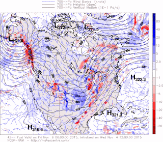
Now here is the Vertical Motion Index, this is a map that measures the amount and location of the most expected lift in the Atmosphere. As you can see, this model has the bulk of the Instability centered around West Arkansas. This map is valid through the Overnight hours on Thursday.

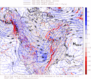
Now here's the same map, different weather model, this is the GFS (Global Forecasting System), the model up above is the NAM (North American Model). The name is around the same timeframe, but it showes the majority of the instability centered around the Squall Line itself, but not much instability that will be widespread (Scattered). Now should this verify, this will be a pretty potent little squall line. Damaging Straight Line Winds would be primary concern in this case, but brief Spinup tonadoes along the kinks on the line itself is not out of the question.
Now, realistically at this point I'm leaning more torwards the predictions of the GFS model, it seems more realistic and sensible to me rather than the NAM breaking everything up and having stuff scattered. I encourage everybody to stay tuned to my social media as well as your local weather service, and new station outlet. Turn on your NOAA Weather Radios, those things will sound off and wake you up if bad stuff comes your way.
Follow me On Social Media
TheArkansas WeatherHawk - Facebook
@OmarrWilson - Twitter
The Arkansas Weather Hawk - Google Plus


Comments
Post a Comment