Preliminary Christmas Outlook
Hey Good Evening Everybody, How's it Going! The big story weatherwise has been the unseasonably mild temperatures that we've been experiencing. Now in my last update I explained how I mainly think this is due to an extension of our Fall Season Overlapping into our Winter Season because it's come LATE this year just like everything else. Now although I know that kind of sounds a little bit "Off" compared to what other Forecasters are saying, and it doesn't necessarily fall in line with everybody else, but ARKANSAS WEATHER is out there! LOL! However, no matter how far fetched things may sound, all I can do is interpret the weather data, and the weather itself, and give you guys my interpretation of what I see. Nothing more or less. A lot of times I tend to be right, not all the time, but a lot of times. I just credit that to my natural ability to understand mother nature! But anyways, I digress, on to this Christmas!
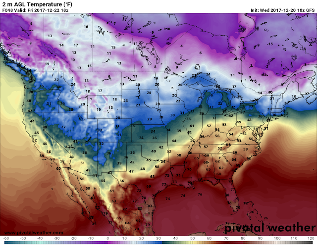
Now it sees to me that there are Two systems in between us and Christmas. One system this Wednesday, and the next system next Wednesday. This system looks to bring just scattered showers, with chilly air behind it and chilly temperatures to close out the week. But by end of Weekend, we'll be back warm again. Next week this next system is only visible on the GFS (Global Forecasting System) Weather Model, and the GEM ( Canadian Weather Model). The GFS shows the next system next Wednesday or Thursday'ish, and show's it with more moisture, RAIN. The GEM show's a more dramatic version of the GFS. So at this time I do see a Chance for rain around the Christmas eve timeframe, and a Mild-Cool Christmas following that front. I KNOW this will change over the next few runs, so stay tuned!!!
Now it sees to me that there are Two systems in between us and Christmas. One system this Wednesday, and the next system next Wednesday. This system looks to bring just scattered showers, with chilly air behind it and chilly temperatures to close out the week. But by end of Weekend, we'll be back warm again. Next week this next system is only visible on the GFS (Global Forecasting System) Weather Model, and the GEM ( Canadian Weather Model). The GFS shows the next system next Wednesday or Thursday'ish, and show's it with more moisture, RAIN. The GEM show's a more dramatic version of the GFS. So at this time I do see a Chance for rain around the Christmas eve timeframe, and a Mild-Cool Christmas following that front. I KNOW this will change over the next few runs, so stay tuned!!!
As Always I want to thank you all for your support, and coming here to the Weather Hawk's Blog!
Follow Me On Social Media
TheArkansas WeatherHawk - Facebook
@OmarrWilson - Twitter
The Arkansas Weather Hawk - Google Plus


Comments
Post a Comment