Deadly New Year Weather: WINTER WEATHER UPDATE
Hey everybody, how's it going. Well I hope y'all are SAFE AND WARM tonight while reading this. Y'all are probably here for answers as to what the weather will be like, and I know that my title to this doesn't really grant much confidence. But the title is accurate to what we can expect, I'll explain.
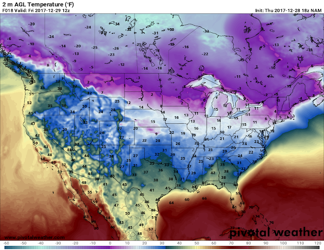
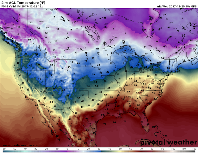
Temperatures - Okay, well it's COLD....... Plain and simple, tonight wind chills will be in the teens, actual air temperatures will be in the teens as well in certain areas. Tomorrow (Friday) the temperatures will be a little warmer than it was today, tomorrow the temperatures can possibly get to the 40s (Still Cold), but it's warmer than 32. Now Friday night into Saturday Morning a cold front will move through, once that front moves through that will open the flood gates into the cold air, and this is expected to take place come Sunday (New Years Eve). From Saturday all the way through Tuesday the temperatures will be BELOW freezing (32 Degrees). That's what's referred to as "Pipe Busting Weather", we call it that because multiple days of subfreezing air will cause you water pipes underground to burst and backup, thus causing your water to be out for an undetermined amount of time. So, with that being said, drip your faucets everyday after Saturday up until Wednesday. See Pictures Below:
Temperatures - Okay, well it's COLD....... Plain and simple, tonight wind chills will be in the teens, actual air temperatures will be in the teens as well in certain areas. Tomorrow (Friday) the temperatures will be a little warmer than it was today, tomorrow the temperatures can possibly get to the 40s (Still Cold), but it's warmer than 32. Now Friday night into Saturday Morning a cold front will move through, once that front moves through that will open the flood gates into the cold air, and this is expected to take place come Sunday (New Years Eve). From Saturday all the way through Tuesday the temperatures will be BELOW freezing (32 Degrees). That's what's referred to as "Pipe Busting Weather", we call it that because multiple days of subfreezing air will cause you water pipes underground to burst and backup, thus causing your water to be out for an undetermined amount of time. So, with that being said, drip your faucets everyday after Saturday up until Wednesday. See Pictures Below:
This is the 18z run of the NAM (North American Model), it's showing 25 degree temperatures tomorrow morning. So if you're going to be out working, or going to work in the morning, PLZ DRESS IN BUNDLES.
This is the NAM valid Friday evening, it shows highs in the bottom 40s. Then it will cool down and we'll be in the 20s Saturday morning. Saturday evening we may get up to 33 degrees, then Sunday (My Birthday) we'll be below freezing from there on out.
This is the Monday morning projections, Low 20s majority of the state. Check on Your neighbors, pre-warm your car before driving off, and TAKE YOUR PETS AND VALUABLE PLANTS IN DOORS. Some spots will get into the teens....
This is the latest 00z (Midnight run) of the GFS (Global Forecasting System) showing teens as air temperatures. People that is seriously cold temperatures. It's 18 degree's if you do not have GLOVES on your hands will develop Frost Bite (FREEZE) in minuets. Hypothermia set's in in 20 minuets tops, I mean it wen I tell you to BUNDLE UP...
Now as far as moisture, will there be snow? Ice? What is it going to do? Well, there is a SLIGHT CHANCE on Sunday that there will be SCATTERED moisture in far South Arkansas, the cold air will make it that far south, so if it does rain anywhere, it will freeze. I DO NOT think enough will fall for any accumulations, I do not think we will have many scattered flurries. Sure wherever scattered light showers set up you may see a flurry or two flying in the air, but nothing heavy enough to accumulate or even cause any problems. But however, if it does rain somewhere, not saying it will, but IF it does, it will freeze instantly on contact, so that will be something to watch if you're traveling. If you're traveling CHECK THE FORECAST. Now this is expected during the day on Sunday. See Pictures below:
Now this is the 00z run of the NAM and it show's nothing at all on Sunday. This is only 1 Model, and this is only 1 run out of many more between now and then, so this can change!
Now this is the 00z run of the GFS and this is valid same time as that map above, Sunday morning, and it show's VERY LIGHT scattered showers out in South Arkansas and in West Arkansas as well. Even if this verify, this will only be flurries, or just very light freezing rain. Once again, I do not think any precipitation accumulations will come out of this.
This is my official New Years Eve, and New Years forecast. COLD, and dry, maybe flurries at best at some point. But the main story here is the bitter cold, if you plan on being outside at any point over the next 5 days, dress accordingly. From Sunday night to Wednesday drip your faucets, and bring pets and plants in doors. If you have any questions or concerns, please feel free to ask. Thank You all for waiting on this update, and coming here to the Weather Hawk's Blog! Have a SAFE, AND WARM NEW YEARS EVERYBODY!
Follow Me On Social Media:
@Omarrian Wilson - Facebook
@OmarrWilson - Twitter
+The Arkansas Weather Hawk - Google Plus
@thearkansas_weatherhawk - Instagram


Comments
Post a Comment