PRELIMINARY Christmas Weather Forecast 2017
Hey everybody how's it going tonight! I hope all has been well for the past few weeks. For everybody that follow me on social media, I know that you guys have been looking forward to this forecast because there has been talk floating around of a pretty active weather pattern ahead. So, with that said let's dive into it shall we.? Now, just before I get into this, I want to say THANK YOU to everybody on my social media for all of your support for what I do with this weather forecasting, I love you guys, and you all are freaking awesome!
Now, before I get to Christmas we have business to discuss for this weekend. As you all know we have not had substantial rain in WEEKS. Right now we are in an extreme drought conditions due to rain and the lack thereof. There is no doubt that right now we need rain, but if you remember correctly on my "Official Winter Forecast" that I made last month, I mentioned that the beginning of Winter would be a "Late El Nino" setup. I mean right now we have a weak La Nina breaking down into an El Nino Setup, which is giving us exactly what I said we would get, shots of COLD and DRY air.! That's what we've been getting, I mean average highs over the past month have been in the Mid 50s - Low 60s. There have been days where we've gotten into the Mid 60's, but for the most part it's been average temps, only on certain occasions we'll get shots of bone chilling air, that's exactly what I predicted. Now for this weekend, we have a chance for rain on LATE Saturday Night and into Sunday Morning (early). See Pictures Below.


@thearkansas_weatherhawk - Instagram
Now, before I get to Christmas we have business to discuss for this weekend. As you all know we have not had substantial rain in WEEKS. Right now we are in an extreme drought conditions due to rain and the lack thereof. There is no doubt that right now we need rain, but if you remember correctly on my "Official Winter Forecast" that I made last month, I mentioned that the beginning of Winter would be a "Late El Nino" setup. I mean right now we have a weak La Nina breaking down into an El Nino Setup, which is giving us exactly what I said we would get, shots of COLD and DRY air.! That's what we've been getting, I mean average highs over the past month have been in the Mid 50s - Low 60s. There have been days where we've gotten into the Mid 60's, but for the most part it's been average temps, only on certain occasions we'll get shots of bone chilling air, that's exactly what I predicted. Now for this weekend, we have a chance for rain on LATE Saturday Night and into Sunday Morning (early). See Pictures Below.

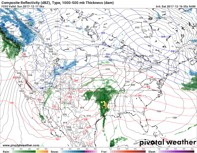
This Map here is the 00Z (12AM Midnight) run of the NAM (North American Model) this is valid between the hours of 3am and 6am Sunday Morning. As you can see here a front will start to move into West Arkansas bringing a huge shield of rain along with it.

This is the same 00Z run of the NAM, valid from 6am - 9am Sunday Morning, and as you can see here a clear frontal boundary of MUCH NEEDED rain will move through the state Sunday Morning.
Now that's short term pretty much the only thing expected, no storms, maybe an embedded rumble of thunder and locally heavy rainfall, but otherwise, I don't expect anything in the way of severe weather with this. Now that very front that will bring us the rain Sunday morning will stall to our south and provide northern Louisiana with good chances for rain from Monday - Wednesday of this upcoming work week. But the front will rise back to the North into Southern Arkansas on Wednesday giving Southern Arkansas a chance for more rain on Wednesday. Other than that, we remain dry for majority of the state until next Weekend.
Now getting to next weekend..... This is the part of the Forecast that everybody has been waiting for, it's Christmas Weekend, and it's a chance for frozen stuff. So let's get into it! OKAY, So a Cold Front will Move into the State on the Morning of Friday December 22nd, with it will come the chance for LIGHT Freezing Rain/Sleet for NORTH Arkansas, it may not even hit the ground to be honest, but the main story with that is AIR!!! That Front will bring us the COLD AIR that we need in order to give us our chances that we have! Now almost simultaneously as that front is moving into North Arkansas, a disturbance will be organizing in Texas, this will supply us with the moisture that we need.

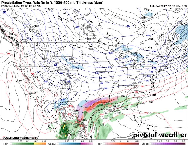
This is the 00z run of the GFS (Global Forecasting System) this is valid morning of Friday December 22nd, you can see clear as day the cold front start to make it's way into North Arkansas, Meanwhile you see that disturbance in Texas. The front gives us air, the disturbance gives us moisture.

Now you can see here the moisture coming in with the front is minimal, but it does show light precips in North Arkansas, not important, who cares.! The important factor here is air, which it clearly brings shown in the form of those blue lines there, they're draped across the state.

Now we got the air, here comes the moisture. This is the GFS Saturday Decemer 23rd in the Afternoon - Evening Hours. As you can see, the moisture is COMING!! Cold Air is here, it's settled in, moisture is on the way.

Now this is the GFS Valid Morning of December 24th (Christmas Eve) it shows SNOW on the move North, followed by Sleet, followed by what could possibly be freezing rain.... NOW, when you look at this, you get excited, because for some time now these models have been VERY consistent with snow, and frozen precips. Granted the times and days have switched up a bit, but the models have been VERY consistent with this Outcome. So Our chances for a "White Christmas" at THIS early point in the game really is a true possibility!
NOW, THIS IS A PRELIMINARY (EARLY) FORECAST, we are still 8-9 days out. This is still VERY EARLY, so these details can and WILL change over the next few days as the models tend to "Fine Tune" themselves as we get closer to weather anomalies. So I say that to say this, NONE OF THIS IS FOR CERTAIN. Right now it is entirely to early to every throw some accumulation numbers out there. What I can tell you is that Cold Air ALWAYS move faster than Weather Models suggest, so I do believe the chance is there to get good stuff. On WEDNESDAY DECEMBER 20TH I will do an Official Christmas 2017 Winter Weather Forecast which will have Newer, more certain details about what's expected to take place. This here is just an early prediction if you will, of what the possibilities are. THANK YOU ALL FOR COMING HERE TO THE WEATHER HAWK'S BLOG!!!!!
Follow Me On Social Media
@Omarrian Wilson - Facebook
@OmarrWilson - Twitter
+The Arkansas Weather Hawk - Google Plus


Comments
Post a Comment