Christmas and Beyond: *WINTER WEATHER UPDATE*
Hey Everybody, Merry Christmas Eve!!!!! And, Merry Christmas to all.! I PRAY for all that's on the road or in the air traveling on this Christmas holiday! I pray that you guys have safe travels, and make it to your destinations with no issues. Now the purpose of me doing this update is to kind of cover some new model guidance that has come in, especially in regards to tomorrow (Christmas). So I don't want this to be a huge 15 paragraph update, let's cut straight to it!
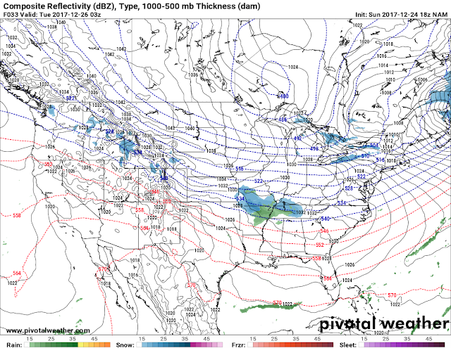
The NAM (North American Model) is picking up on a disturbance moving through the state on Christmas Night into Tuesday morning. Now I've been getting questions about the likelihood of this verifying, and to be honest I don't think it will. BUT, with that being said since we're so close in time, you never know, maybe the NAM VERIFY, if it does then we appear to have a chance for some flurries or even some light snow showers for North Central Arkansas, it would be rain showers all elsewhere probably. Now once again, I DOUBT THIS VERIFY, I honestly think there will be light showers IF ANYTHING okay. But it is Arkansas, so I could be wrong. See Pictures Below:


@thearkansas_weatherhawk - Instagram
The NAM (North American Model) is picking up on a disturbance moving through the state on Christmas Night into Tuesday morning. Now I've been getting questions about the likelihood of this verifying, and to be honest I don't think it will. BUT, with that being said since we're so close in time, you never know, maybe the NAM VERIFY, if it does then we appear to have a chance for some flurries or even some light snow showers for North Central Arkansas, it would be rain showers all elsewhere probably. Now once again, I DOUBT THIS VERIFY, I honestly think there will be light showers IF ANYTHING okay. But it is Arkansas, so I could be wrong. See Pictures Below:

This is the 18z Run of the NAM (North American Model) now quick side note, the 00z run of the NAM is coming in right now as I type so maybe this chance could be gone after I put this out. If it changes then I'll edit this out, if you guys actually see this part then the NAM is consistent, so we'll see. BUT, as you can see here the NAM is hitting on a wave of moisture swinging through LATE tomorrow night and into Tuesday morning. If this verify then we will see light to moderate snow showers over North Arkansas. Rain possible further south. This Image is valid between Midnight and 3am Tuesday Morning.
Now all the latest runs of the GFS (Global Forecasting System) weather model does NOT show anything on tomorrow, Tuesday, or even Wednesday. The GFS doesn't get interesting again until New Years in my opinion. YES, the GFS is picking up on a disturbance on Thursday night into Friday morning, but I don't personally think in my head that it will mount up to anything, maybe flurries at best but again it's currently SUNDAY, Thursday is still 4 days away, this can change! See pictures below:

This is the Sunday 18z run of the GFS this Image is valid Thursday evening and it shows a wave of moisture associated with a disturbance that brings in the possibility of a mixture across North, and Central Arkansas.

This is the 18z Run of the GFS 2m Temperature Map, this is valid same time as the map above Thursday evening, and it shows a pocket of cold air into central Arkansas. So granted the moisture get's as far south as Central Arkansas, then ACCORDING TO THIS, Yes a mixture of sleet is possible. But I say again, we're 4 days out, and there's SEVERAL model runs to be seen in 4 days, on any 1 run all of this could look different. So let's take this day by day. I wouldn't take this literally right now at all to be honest, but the card's on the table.

This is the GFS valid next Sunday December 31rst (My Birthday), and it show's a shot at snow...... NOW, when you look at this, DO NOT get excited and say "it's supposed to snow next weekend" because next weekend is a FULL WEEK away, and it's meteorologically, and scientifically impossible to be certain about what's going to happen a full 7 days away. This could be here this run, and gone the next. But, the GFS shows at least the possibility of stuff next weekend. Whether this verify or not, we'll see! But this would make a cool birthday present though LOL, I LOVE SNOW!!!

Now this is the latest 00z (Midnight) run of the NAM (North American Model), this image is valid between the hours of 10pm Monday night and Midnight Tuesday morning. This model show's a chance for rain to the south into North Central Arkansas, and POSSIBLY some embedded snow flakes to the north. This one run is as little bit different from the last run (the first picture in this post), now you guys see how much these models can change details from run to run, that makes forecasting hard....
At this point in the game, these are some of the latest weather developments. Of course if anything significant changes in the model guidance I will most definitely do another weather update, and give you guys all the latest weather info. Meanwhile, You guys have a Merry Christmas Eve, and a Merry Christmas, and safe travels everybody. !!!!
Follow Me on Social Media:
@Omarrian Wilson - Facebook
@OmarrWilson - Twitter
+The Arkansas Weather Hawk - Google Plus


Comments
Post a Comment