Hurricane Weather Update/ Weekly Forecast 8/25/17
Hey Everybody! How's It going! I'm doing this update briefly because we have to discuss a few things. We have to discuss this hurricane, and how it will effect our weather, that's the major story here. So let's jump straight to it.
I been watching the Tropical System since last week, since it became a Tropical Depression. I personally didn't expect it to be what it is due mainly to the fact that I expected it to speed up, and not have a chance to develop properly because it would move over the warm ocean water too fast to grow. BOY WAS I WRONG! The Exact opposite of what I thought was going to happen is what happened. This thing slowed down, took in that good ole warm ocean water, and has turned into a MONSTER. It grew to a Category 4 Storm in very little time, the thing has simply exploded. I'm serious, a few more hours (6-12) over open ocean and we'd be dealing with a Category 5 Storm (The first one in the South US in way over 10 years). So, that's just how serious this storm is. I do not think many people has had the opportunity to evacuate due to the very rapid intensification of this Storm. I truly hope everybody that is hunkered down in Texas is safe from Wind, Rain, and Water. My Prayers will be with you all!
Now, how does this Storm Effect our weather here in Arkansas.? For Now, It doesn't! That storm will stay confined to the south due to the lack of forward momentum. So for awhile it will be tropically quiet here. We have a Storm System from the north moving in by Monday evening, and overnight. It will bring with it chances for rain, and some scattered thundershowers, nothing too major though.

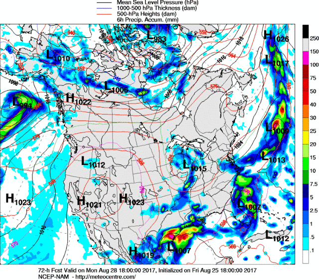
This is the NAM (North American Model) it show's the storm system from the north moving into Central Arkansas by 6pm Monday evening, or sometime before. Nothing too Severe.
But see when you get out towards Wednesday night all the way through next Monday According to the GFS (Global Forecasting System), a storm system will come in behind the Tropical System Harvey and give it a little push to the North. Now, that being said this is expected to happen Wednesday Night, so from right now Friday August 25th, to Wednesday August 30th this system will sit over south Texas and dump torrential rainfall, that's crazy! But, eventually this system will move, and it will push Tropical Rain up to Arkansas. NO Strong winds is expected, I mean maybe gusty winds at the most, but I doubt the winds be that bad. The big story here is rain. This is Very far out in advance, so some details may change, but the GFS is saying Wednesday Night all the way through Monday September 4th NOTHING BUT RAIN..... Maybe this will teak a little bit, maybe this will change a lot. But as of now, that's what I'm gathering from the GFS.
No Rain Total estimates for Arkansas yet, too far out in advance! But I will get them out ASAP when we get closer in time. If you guys have ANY QUESTIONS OR CONCERNS, ANY AT ALL! Plz Feel free to ask me! Thank You guys for coming here to the Arkansas Weather Hawk's Blog, Have a Good Night everybody!
Follow Me On Social Media
@Omarrian Wilson - Facebook
@OmarrWilson - Twitter
@The Arkansas Weather Hawk - Google Plus


Comments
Post a Comment