The Arkansas Weather Hawk - Official 2017 - 2018 Winter Weather Forecast
Hey everybody, how's it going! The time has finally come for the Official Winter 2017 Weather Forecast! I know a lot of people has been expecting this, so lets get into things shall we! There is A LOT to cover so lets get into it!
First thing's first, when it comes to predicting winter weather the START of all of it, being warm, cold, wet, dry, snowy, icy, etc. It all starts with the climate setup. There's something called the Arctic Oscillation (AO for short). The AO is basically the state of the rotation of air around the North Pole. There are two phases of AO, when the AO is in it's Positive Phase, that means there's a state of Low Pressure around the north pole that keeps the cold arctic air confined to the north pole, and it leaves the rest of the lower 48 dry, and warm for the winter season. Now to the opposing side, when the AO is in it's Negative Phase, this means that there is a state of high pressure around the north pole, which pushes the cold air south into the lower 48 which is known to produce a fairly productive winter as far as snowstorms, and winter weather is concerned. Check Diagrams below.


First thing's first, when it comes to predicting winter weather the START of all of it, being warm, cold, wet, dry, snowy, icy, etc. It all starts with the climate setup. There's something called the Arctic Oscillation (AO for short). The AO is basically the state of the rotation of air around the North Pole. There are two phases of AO, when the AO is in it's Positive Phase, that means there's a state of Low Pressure around the north pole that keeps the cold arctic air confined to the north pole, and it leaves the rest of the lower 48 dry, and warm for the winter season. Now to the opposing side, when the AO is in it's Negative Phase, this means that there is a state of high pressure around the north pole, which pushes the cold air south into the lower 48 which is known to produce a fairly productive winter as far as snowstorms, and winter weather is concerned. Check Diagrams below.

This is a diagram of a Positive AO, as you can see, as I previously stated, there is a state of Low Pressure around the North Pole which keeps the good stuff in the north, meaning, boring winter for us Americans. Again, this is a Positive Phase AO.

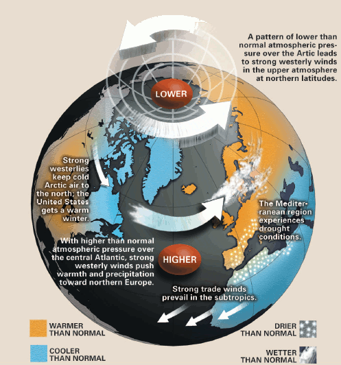
Now as you can see, this is the complete opposite of positive, this is the negative phase AO, in this phase there is a state of High Pressure, which due to weak crosswinds moving around the planet, the cold air is allowed to dive further south into the lower 48 which dries out the Arctic and sets us up for a productive winter, winter weather wise.
Now, with this in mind..... What is the Forecasted AO for Winter 2017? This Winter I'm expecting the AO to be fairly Neutral, meaning neither excessively Positive, or Negative. But there will be short periods of both Positive and Negative. Which will give us periodic shots of Cold Air, and periodic periods of average temperatures. But that's for the first half of winter, as the winter progresses, the AO Phase is expected to trend negative, which will give us the cold air that we need.
So that, AO is out of the way, next is the Sea Temperature anomalies(Events) called El Nino/La Nina. El Nino is a part of a regular fluctuation of the Tropical Pacific Ocean Waters near the equator. When the ocean temperatures in the Pacific Ocean near the equator warm up by a few degrees it creates warm westerlies that blows towards the east into the Central America area, and the North side of South America. The Jet Stream will force those winds north into the Gulf Of Mexico towards the US. When these crosswinds blow through, it prevents hurricanes from forming due to the "Windshear" ...... This is a LATE El Nino Year. The Pacific Ocean is warmer than average, but those crosswinds from that warm water is expected to be LATE this year, which is why we've seen the strong tropical storms we've seen this year. Now for La Nina, La Nina is the exact Opposite of El Nino. La Nino is when the Pacific Ocean is cooler than average. But as crazy as it is, El Nino/La Nina has adverse affects on the US...... El Nino Sets us up for wetter more moist air. La Nina set us up for drier cooler air. See below

See this is the effect that a La Nina have on the United States. Drier air over the southern US more Moist air over the north. El Nino is the exact opposite of that. Now NOAA states that there is a 50-60% chance for a La Nina this year. So our shot at Moist or Dry air is a 50/50 shot.

See La Nina forces the Warm dry air into the southern US. Which throws us into a boring winter.......
But check this, when you have a NEGATIVE AO (Cold air Tanking south), and La Nina Temperatures at the Surface, that puts warm over cold....... Which means ICE. Rain falling from the clouds, freezing into the cold surface temperatures, that means freezing rain and sleet. Depending on how shallow that cold air is, you could have snow. But in this particular scenario, ice is more of a reality.
Now what do I expect, El Ninio or La Nina? I'm expecting an El Ninio this year, which would set us up for a good opportunity for snow due to the supply of moisture.
Okay, now with ALL OF THIS BEING SAID...... What is my prediction of Winter 2017? I'm expecting this winter to be a game of cat and mouse with dry air.... The Cold Air will be in no short supply. It will take a minute to really just sink into this cold air, we will see periodic warming in the midst of the cold. Which will send our temperatures on a roller coster ride, which will give us hit and miss chances for cold air. Now once that Cold artic air really sinks in, we will be cold! As far as moisture goes, there is a significant chance for drier air, whether it's cold or not, dry air gives us nothing. But there will be no shortage in shots of moisture which will give us something! I'm thinking more of a chance for Ice than anything else! Cold Thanksgiving, Cold Christmas, Windy New Years, Good opportunities for Snow January-March.
There it is, my Official Forecast for the Winter of 2017! Thank You everybody for coming here to the ARKANSAS WEATHER HAWK'S BLOG! If you read all of that! You're the truth! And I Love You! If you have ANY QUESTIONS, ABOUT ANYTHING AT ALL! PLZ ASK!!!!!
Follow Me On Social Media
@Omarrian Wilson - Facebook
@OmarrWilson - Twitter
@The Arkansas Weather Hawk - Google+
@thearkansas_weatherhawk - Instagram


Comments
Post a Comment