WINTER WEATHER UPDATE: 12/8/18 Saturday Snow
Hey Everybody, how's it going!? I hope everybody is having a fantastic night so far, and I hope all has been well. Of course we have a developing Winter Weather situation coming together here in the state, and everybody except Santa Claus has made an update about it, everybody has thrown their spin, and two cents in about whats going to happen tomorrow. Now for mine!
As fas as the What? Im expecting an initial changeover to Freezing Rain/Sleet from a cold rain, then changing over to Snow. For some areas I'm expecting sleet/freezing rain changing over to snow LATE Saturday. For certain areas I'm expecting mostly a cold rain, POSSIBLY changing over to Sleet LATE SATURDAY. As Far as how Much, well the Models are projecting 4-6" up north of Searcy, and 2-4" around Searcy - Clinton. A dusting to a trace for Central Arkansas if that.

As fas as the What? Im expecting an initial changeover to Freezing Rain/Sleet from a cold rain, then changing over to Snow. For some areas I'm expecting sleet/freezing rain changing over to snow LATE Saturday. For certain areas I'm expecting mostly a cold rain, POSSIBLY changing over to Sleet LATE SATURDAY. As Far as how Much, well the Models are projecting 4-6" up north of Searcy, and 2-4" around Searcy - Clinton. A dusting to a trace for Central Arkansas if that.

This is the Latest run of the NAM it shows the Initial changeover to sleet by 6am tomorrow morning in north central Arkansas.

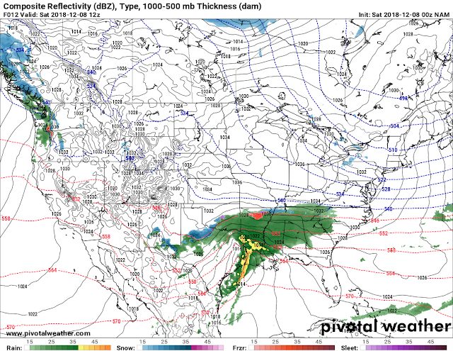
This is by 3pm Saturday Afternoon there are 3 different types of prescriptions in the state. Sleet - Snow up North, and Rain - Sleet further south into Central Arkansas. How far south that snow gets is ANYBODY'S GUESS TO HAVE.
As far as When? The timing on this is early Saturday morning with the initial changeover, Saturday afternoon with Freezing Rain/Sleet mix, and Saturday evening with Sleet/Snow mix, and Saturday night changing over to all Snow. This stuff is GONE by midnight Sunday morning.
As far as Where? Well I'm saying along a Line from Fort Smith, to Russellville, to Clinton, to Searcy, to Agusta, to Jonesboro. That North/2 of the State along that line through those Cities, and Everywhere in between on NORTHWARD is where I expect the highest Accumulations..... Let Your Imaginations run wild on that one. Now there have been SEVERAL disagreements, and discussions regarding where everything sets up, and when. Every Meteorologist, and every Forecaster interpret Weather Models differently, so everybody will have their own spin on what's expected with something like this. Now I'm thinking exactly what I said, IF CENTRAL ARKANSAS GET ANYTHING, it will be Late in the Afternoon Saturday, rain will Changeover to SLEET. Sleet MIGHT Changeover to Snow at the tail end of it here in Central Arkansas, but we'll have to play it by ear. As far as everybody else South of Little Rock it's a Cold Rain, as far as everybody NORTH of Little Rock (North of I-40) there will be changeovers, from rain to sleet to Freezing rain, then eventually to snow. Thanks for Coming here to the Weather Hawks Blog everybody, have a SAFE night, and STAY SAFE On the Roads, and watch BRIDGES AND OVERPASSES.
Follow Me On Social Media
@Omarrian Wilson - Facebook
@OmarrWilson - Twitter
@The Arkansas Weather Hawk - Google Plus
@thearkansas_weatherhawk - Instagram


Comments
Post a Comment