PRELIMINARY Arkansas Fall Outlook 2K18
Hey everybody! Welcome back to the Arkansas Weather Hawk's Blog!!! Today I'm releasing my Preliminary Fall Weather Outlook for Arkansas! This is only a PRELIMINARY Forecast, meaning this is a premature, early look at just my early thoughts about this coming fall! This is not an Official Forecast, that will come later. But first, I will cover the Short Term.
Lot's of questions I've been getting is when will we have more rain? Another question, is what will the temperatures be like heading into October? Here I will answer those questions. Now, as far as rain, I've checked all 4 weather models that I study, and from what I've seen, our next substantial chance for rain will be this weekend, either Saturday, or Sunday. That chance for rain will come in the form of showers and storms associated with a disturbance that will be moving this way out of the Rockies. The NAM ( North American Model) shows a "Squall Line" (Line of Severe Thunderstorms, and strong winds) trying to develop out in the Central Plains. The line of storms will move this way on the way East. So that will be our next opportunity for rain, after that will be next week, around Wednesday, or Thursday. The NAM doesn't go out that far into the long range, for that I went to the GFS (Global Forecasting System), the CMC (Canadian Model), and the EURO (European Weather Model). All three Weather Models show this possibility along with my next point, TEMPERATURES!!!!!
Main question I've been getting is, When will it start to feel more like Fall? Well funny thing you guys ask! Well, the GFS and the EURO Weather Models pick up on our next "Polar Vortex." You guys remember sometime ago I made a huge Weather Update about some unseasonable temperatures for Arkansas Summer. In that update, I explained what a "Polar Vortex" is, and why it happens, if you need to know what that means, or what it is, refer back to that post, I went in detail about what it is, and why that happens. But long story short, we have a Polar Vortex coming, and that dip in the Jet Stream will let those temperatures dip down. These are VERY EARLY predictions, but the GFS has been consistent with 60s, and even 50s here next week! A temperature swing is coming! Check out the Pictures below!
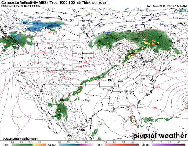

This is the 12pm run of the NAM, as I said it shows this next system as a Line moving out of the Rockies, I can't really say for sure whether there will be much Severe Weather with this system as it moves through. Based of the GFS, and EURO I don't see much of a chance for Widespread Severe Weather, but I do think there will be a threat for Straight Lined Winds with this Line as it moves through if it develops, and hold together. GFS has this pegged at Saturday into Sunday.

This is the Latest run of the GFS, you can see nearing the end of Next week, you can see the "Polar Vortex" is coming. You can clearly see where the front is, so this is the swing I was talking about. The main punch of the cold air will be in the northern states, but we will get a chill down as well. From Wednesday Night, into Thursday all the way through Monday of week after next, (the first week of October) the temperatures will be nice and chilly.

Next Friday, the temperatures are just beginning to dip into the 60s. This is Friday September 28th, 12am Midnight.

Let's jump ahead to Monday October 1rst, Midnight. Mid 50s here in Central Arkansas! EVERYBODY Has been asking, When will the more Fall Like Temperatures arrive!!!! Well Here's our first Official TASTE OF FALL!!! **DO NOT take these temperatures verbatim, the numbers might change because as of now it is September 17th, so this is very far out in the Long range, so those numbers will change over the coming days. But for all that's wanting cooler air, You're Welcome!
NOW, That's my 14 day Forecast! Let's move on to my early expectations for Fall of 2018!
This fall I'm expecting a Late "El Nino" Weather Pattern! But, there will be a "Negative AO" (Arctic Oscillation) this winter. Now with a "Positive AO," the Cold Arctic Air is confined to the Arctic Circle, and Northern Canada. But with the Negative Phase AO, that means that there is High Pressure in the Arctics, and there will be dips in the jet stream that will allow that colder arctic air to dive south through the lower 48, and that gives us shots of cold air, which in turn gives us chances for Winter Weather. What "El Nino" does is opens up a feed of Moist air from the Pacific, and Gulf Of Mexico. But that air is always warm.... So El Nino warms up the South 1/2 of the country, because the El Nino temperatures are the strongest along the equator in the Pacific Ocean. But this El Nino setup is expected to be weak. So with El Nino around, that means warm and mild for the Southern 1/2 of the USA. But,with a Negative Phase AO, and periodic dips in the jet stream, that will mean at, or Below Average temperatures for the Mid South. Without the Negative AO we'd have a Warm Fall. But our AO is Phase Negative, so the door that keeps all the cold air up there in the arctic is wide open, so that cold air will sink south and give us shots of cold! So I think this Fall will be mild, with shots of cold/chilly air. Those are my early preliminary thoughts about Fall 2018. See Pictures below.

All El Nino's tend to have their own different characteristics, but this is generally what a typical El Nino Weather Pattern setup is like for the US. Now this year's El Nino is different in certain ways. This year we have a weak El Nino heading into Fall 2018, so what that means is, the warmer air won't be as dominant, which is partially because we have a Negative Phase AO in the Arctics. Now, as for Arkansas, this will work to our advantage, because we have El Nino supplying the moisture, and we have our Polar Vortex to the North supplying the air. Just those two dynamics put together could open the possibilities for different things moving into November and December.
This is a stroll in the park idea of what I've been looking at heading into the fall months. None of this is set in stone, we have a few more weeks of atmospheric developments before I can say in confidence what I fully expect for the fall. But I hope this early forecast helps shed some light as to what I expect, and what I've been thinking about as far as this fall is concerned.! If You guys have any Questions about anything I went over here, or questions about the weather in general, please feel free to ask! Until Next time, THANKS FOR VISITING THE ARKANSAS WEATHER HAWK'S BLOG!!
Follow Me On Social Media
@Omarrian Wilson - Facebook
@OmarrWilson - Twitter
@The Arkansas Weather Hawk - Google Plus
@thearkansas_weatherhawk - Instagram


Comments
Post a Comment