Official Fall 2018 Arkansas Weather Forecast
Hey everybody, how's it going!? I hope everybody is having a fantastic evening. The time is finally here for me to give my official educated pitch at what this weather pattern will be like as we move through the fall months. I can make this Forecast today, and the complete opposite can happen It should be noted that with Long range Forecasting (any forecast extending further than 7 days), everything is always in the air as it relates to accuracy. But when it comes down to it, I base my forecast off of education, instinct, and weather analysis. So, that being said, let's get to this Fall!
Now TEMPERATURE WISE; Today October 10th, 2018 is probably the warmest day we will have for at least the next 7 days. Now the front that brought brief spinups, high winds, and power outages to the state also delivered us the cooler temperatures that everybody has been BEGGING for! Today we got to the 80s here in West Little Rock. But at this time it is 65° here in West Little Rock, that is the way it will feel during the day for the next several days. Now on Monday October 15th, the GFS is projecting Highs in the Mid 40s! If this is to verify, then that's HEATER IN THE CAR WEATHER, that's heated seats type weather right there! Now the GFS is cool by next Wednesday Morning (October 17th), the GFS is looking like mid 40s! The GFS is just 1 model, this is just 1 run, so it's subject to change.! LONG RANGE; Around Halloween, look forward to Cooler temperatures than normal! Moving past Halloween, I'm very confident at this point that this Fall will be cooler than normal with periods of warmer weather. It'll be in the 60s and 70s throughout the remainder up until December, with splashes of 80° temperatures scattered throughout! Temperature wise, I'm expecting JACKET WEATHER! Wear a Jacket on Halloween, wear a Jacket if you're attending the State Fair, because it will get cooler in the night!
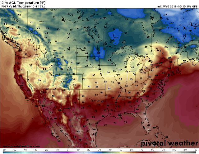

Now TEMPERATURE WISE; Today October 10th, 2018 is probably the warmest day we will have for at least the next 7 days. Now the front that brought brief spinups, high winds, and power outages to the state also delivered us the cooler temperatures that everybody has been BEGGING for! Today we got to the 80s here in West Little Rock. But at this time it is 65° here in West Little Rock, that is the way it will feel during the day for the next several days. Now on Monday October 15th, the GFS is projecting Highs in the Mid 40s! If this is to verify, then that's HEATER IN THE CAR WEATHER, that's heated seats type weather right there! Now the GFS is cool by next Wednesday Morning (October 17th), the GFS is looking like mid 40s! The GFS is just 1 model, this is just 1 run, so it's subject to change.! LONG RANGE; Around Halloween, look forward to Cooler temperatures than normal! Moving past Halloween, I'm very confident at this point that this Fall will be cooler than normal with periods of warmer weather. It'll be in the 60s and 70s throughout the remainder up until December, with splashes of 80° temperatures scattered throughout! Temperature wise, I'm expecting JACKET WEATHER! Wear a Jacket on Halloween, wear a Jacket if you're attending the State Fair, because it will get cooler in the night!

This is the Noon run of the GFS (Global Forecasting System). This is the High temperature for tomorrow. As you can see it's slated to top out in the upper 60s. I'd say that's about accurate! This will continue with Lows going into the 50s at night between tomorrow, and Monday the 15th.

This is the 18z GFS it's valid Midnight Tuesday October 16th. These are the coolest temperatures I've found within the next 15 days, MID 40s !!! Ask, and You Shall Receive! Now the Highs on Wednesday will be in the Mid 60s, while it's not expected to get out of the 50s on Monday! 60s Wednesday, and Thursday, and Friday of next week, lows in the 40s and 50s all next week! IT WILL BE CHILLY!!!
Okay, now as far as Precipitation goes, over the next 14 days I'm looking at very MINIMAL chances for rain. The only substantial chance for rain that I see is for Sunday October 14th, into Monday the 15th. The front that will bring those chilly 40° temperatures next week will move through during the day Sunday, and possibly linger into Monday. I'm not expecting any widespread Severe Weather with this, but I do expect fairly decent rainfall totals in certain areas, maybe possible flash flooding, but I don't expect a monsoon of rain. Now That is according to the GFS. The NAM (North American Model) picks up on a disturbance passing by to the North of Arkansas on Friday, that might possibly bring scattered showers. The NAM brings this weekend's front in on Saturday evening, and packs the rain in throughout Sunday. So the NAM brings more chances in for rain over the next 5 days. So we'll see which one verify. AS FAR AS LONG RANGE; I expect this Fall to be about on point as far as precipitation to where it normally is, now we are in our "Secondary Severe Weather Season" which brings in Fall Severe Weather Setups that are similar to the Spring months. So if we have above Normal Precipitation chances/totals from this fall, it'll be due to an active season.
As far as my "LAYMAN'S Terms" opinion about this fall........ I think this fall given the model data, and comparing this Weak - Strong El Nino Pattern to past years, have the potential to be WET, AND CHILLY!!! Im not even going to touch on winter! Thanks for Coming here to the Arkansas Weather Hawk's Blog and checking out my content! Share! And if there's any questions, feel free!
Follow Me On Social Media
@Omarrian Wilson - Facebook
@OmarrWilson - Twitter
@thearkansas_weatherhawk - Instagram
@The Arkansas Weather Hawk - Google Plus


Comments
Post a Comment