Polar Vortex Split!! Temperature CHANGE COMING!!!!
Hey everybody, welcome back to the good ole Arkansas Weather Hawk's blog, where you get the inside scope on what's going on with the bipolar weather in Arkansas! I don't know if some of you have heard of it or not, but we had what's called a Polar Vortex Split. What a Polar Vortex Split is; Is when the Low Pressure Cold air in the North Pole split into two sections of Cold air, when this happens the Jet Stream, which keeps the air trapped up in the Arctic North Pole, starts to wave, and dip down into the southern regions of North America which in turn brings us colder temperatures! Usually this has a tendency to happen during the Winter, but when this happens during the summer, it seems a bit weird, and it will bring us unseasonal temperatures. THIS SUMMER, WE NEED THAT!
This is what a "Polar Split" looks like. Notice how the blue eventually floats over the United States? That happens when the Jet Stream weakens, and allow high pressure to develop, that high pressure breaks up, and dips in the jet stream allows that cold air to dive deeper into the Lower 48. The deeper the dip in the Jet Stream, the further south the cold air gets, and the more powerful the cold air is!
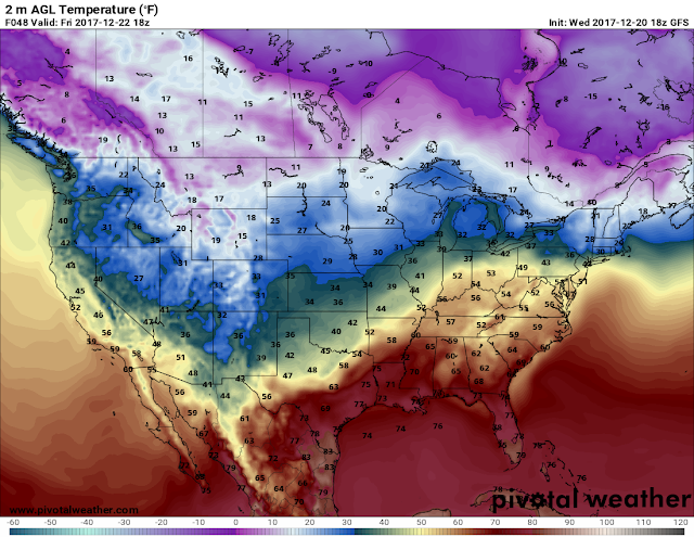
Now that we know what a "Polar Split" is, and what a "Vortex" is, When is this going to happen? Well based off of the model guidance, I'm looking at the end of the month! Starting next Monday! I still see low - mid 90s in the Forecast throughout the rest of the week, and weekend. But come Monday July 30th, you will notice a difference in the air! Yes, 90-94 is I guess considered a break when you've been seeing 102-104 consistently for the past few weeks, sure! But a true COOL DOWN is coming! When I say "Cool Down" I mean 80s during the day, 60s at night!!!! FALL LIKE TEMPERATURES! Get Ready for a Slice of October, In August!
This is the Sunday Noon run of the GFS (Global Forecasting System.) This frame is valid for Next Monday July 30th between the hours of Midnight and 6am, and as you can see it shows 70s!!! IN AUGUST!
This is by Noon Monday July 30th..... MID 80s!!! By 6pm Monday it will only be 85 degrees! That's insane!
This between the hours of Midnight and 6am Wednesday Morning! 60s!!!!! IN AUGUST! I Love it!!!
This is the crazy part!!!! In between the hours of 12 Noon Wednesday, and Midnight Thursday Morning MID 60s!!!!!! IN AUGUST!!!!! Friday looks the same!
**Do NOT** Take these Numbers verbatim. This is more than 10 days into the future, these numbers have changed by at least 10 degrees within the past couple runs. It's not EXACT this far out, but this gives you a ballpark Idea of how AGRESSIVE this cool down will be! DO NOT get spoiled by this, it will be AUGUST IN ARKANSAS, this will only last a few DAYS. But savor the moment, and enjoy it before the armpits of you know what returns! Thanks for coming here to the Weather Hawk's Blog, Stay Safe everybody!!!
Follow Me On Social Media
@Omarrian Wilson - Facebook
@OmarrWilson - Twitter
@The Arkansas Weather Hawk - Google Plus
@thearkansas_weatherhawk - Instagram


Comments
Post a Comment