November 30th 2018** SEVERE WEATHER UPDATE **
Hey everybody, how's it going!? I hope everybody is having a fantastic day so far, I just wanted to bring everybody up to date on this developing Severe Weather Situation here in Arkansas this evening. I've been meaning to post this update, but I'm just now finding the time to, so let's get to it, because this is serious business.
Now, as far as what is expected today? Well as it sits, ALL MODES Of Severe Weather is Possible this evening, and tonight! There is Definitely a Chance for Damaging Thunderstorms, Hail, and there is a threat for Tornadoes. Obviously the main concerns are wind, and hail, and lightning. BUT, Tornadoes are a Legit possibility tonight! Night time storms are particularly deadly because you cannot physically see the weather coming. So HAVE YOUR NOAA WEATHER RADIOS ON! And, Keep the News on Standby, as well as Pay attention to all Social Media News sources for weather information.
Now, as far as what is expected today? Well as it sits, ALL MODES Of Severe Weather is Possible this evening, and tonight! There is Definitely a Chance for Damaging Thunderstorms, Hail, and there is a threat for Tornadoes. Obviously the main concerns are wind, and hail, and lightning. BUT, Tornadoes are a Legit possibility tonight! Night time storms are particularly deadly because you cannot physically see the weather coming. So HAVE YOUR NOAA WEATHER RADIOS ON! And, Keep the News on Standby, as well as Pay attention to all Social Media News sources for weather information.
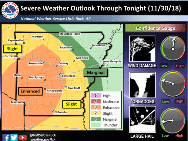
This is an Outlook Map Courtesy of the National Weather Service in North Little Rock Arkansas, as always they have done a fantastic job at outlining the risk, and where. High Threat for Damaging Winds, there's a Medium Threat for Tornadoes. I have Great Confidence that THERE WILL BE TORNADOES SOMEWHERE IN THE STATE TODAY!
This is the Storm Prediction Center's Outlook map, Slight Risk for Severe Weather for Most of the State, but there is an "Enhanced Risk" for Southwest, into parts of Central Arkansas. An "Enhanced Risk" means that there is a Heightened Concern for Severe Weather and Tornadoes for a Particular area.
As for Timing, the Latest Run of the Models Suggests Storm Development around 5-6pm this evening in Southwest Arkansas along I-30... From there the Storms will Rapidly intensify to Severe levels producing a threat for Tornadoes. Storm Movement will be to the North/Northeast. This should be Out by Midnight. A Tornado Watch for Parts of SOUTH, and CENTRAL Arkansas is expected sometime this evening. PLEASE FOLLOW SOCIAL MEDIA FOR UP TO DATE INFORMATION!!!!
Follow Me On Social Media
@Omarrian Wilson - Facebook
@OmarrWilson - Twitter
@The Arkansas Weather Hawk - Google Plus
@thearkansas_weatherhawk - Instagram


Comments
Post a Comment